Latest Topics in News


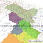
National parks in Kerala
| S.No. | Name of Protected Area | Area (Sq. Km.) |
|---|---|---|
| 1 | Periyar National Park | 350.0 |
| 2 | Eravikulam National Park | 97.0 |
| 3 | Silent Valley National Park | 89.5 |
| 4 | Mathikettan Shola National Park | 12.8 |
| 5 | Anamudi Shola National Park | 7.5 |
| 6 | Pampadum Shola National Park | 1.3 |
The “God’s Own Country” Kerala is highly rich in biodiversity. It have six National Park in it Anamudi Shola National Park, Periyar National Park, Silent Valley National Park, Mathikettan Shola National Park, Eravikulam National Park, Pambadum Shola National Park. The article below contains detail about each one of them!
1. Periyar National Park | Periyar Tiger Reserve
- Periyar holds two protected area designation, Periyar National Park and Periyar Tiger Reserve
- Periyar National park is located in the Idukki District of the Kerala State.
- The Periyar National park ( Periyar Tiger Reserve ) is the largest protected area in Kerala.
- The Periyar lake inside the Periyar National park was created in 1895 by building a dam across the Mullaperiyar river. The lake has an area of 26 sq. km.
- The forest surrounding the Periyar lake was declared as a reserved forest in 1899 and later in 1933, it was declared a sanctuary, the Nellikkampetty Game Sanctuary.
- The sanctuary was brought under Project Tiger in 1977 and it became Periyar Tiger reserve.
- A major part of the Periyar Tiger Reserve lies in the Anamalai-High Ranges.
- Anamalai is one of the centres in the Western Ghats with a high percentage of endemism.
Topography
- Periyar Tiger Reserve consists of a much-undulated terrain ranging in altitude from 100 meters (Pamba valley) to 2016 meter (Vellimala) above sea level.
- Some of the conspicuous peaks in the Periyar Tiger reserve are
- Pachayarmala,
- Vellimala,
- Kottamala,
- Sunderamala,
- Chokkampetti mala
- Karimala.
- The Periyar River originating from Chokkampettimala flows towards the North through the Periyar Tiger Reserve ( Periyar National Park). The name of the reserve is derived from the name of the Periyar river.
- Periyar river major tributaries are Mullayar and Churakkottayar.
- The Western part of the Periyar Tiger Reserve is drained by the Pamba and Azhutha rivers which form the boundary of the Periyar Tiger Reserve.
Geology
- The underlying rock formations in Periyar consist mainly of granites and gneisses.
- Laterite occurs at the lower reaches of the Periyar Tiger Reserve.
- The soil in Periyar Tiger Reserve is mainly fine loamy as it is derived from disintegrated laterite and gneisses.
- In higher altitudes of Periyar, the soil is coarse with a large amount of quartz gravel formed from crystalline rock.
- The soil is acidic in Periyar National Park.
Climate
- The Periyar National Park receives both the South-West and the North-East monsoons with maximum rainfall in July and minimum in January.
- The average rainfall is 2500 mm per year.
Flora
- The vegetation of the Periyar Tiger Reserve can be classified into the following types
- 1. West coast tropical evergreen forests (evergreen)
- 2. West coast semi-evergreen forests (semi-evergreen)
- 3. Southern moist mixed deciduous forests (moist deciduous)
- 4. Southern hill-top tropical evergreen forests (hill-top evergreen)
- 5. Southern montane wet temperate forests (shola)
- 6. South Indian sub-tropical hill savannahs (savannah)
- 7. Southern wet montane grasslands (grassland)
- Majorly we can say the Vegetation in the Periyar Tiger reserve consists of Evergreen, Semi-Evergreen, Moist Deciduous, Shola forests and savannah grasslands.
- species found in the park include:
- Jackfruit,
- Teak
- Kokam [Garcinia indica ] trees that produce a dark purple, plum-like fruit.
- Bamboos
- Rosewoods
- Sandalwoods etc.
- Most of the grassland in Periyar is now planted with eucalyptus.
- The Periyar National Park surrounding area consists of agricultural regions, especially plantations of tea, cardamom, and coffee.
Fauna
- The sanctuary is noted for herds of Asian elephants (All Elephant Reserves in India with Map)
- In addition, the species found in the preserve are:
- Tigers
- Leopards,
- Barking deer,
- Bonnet monkeys,
- Nilgai (Indian antelope),
- Langurs,
- Porcupines,
- Sloth bears,
- Grey jungle fowl,
- Kingfishers,
- Great Indian hornbills,
- Southern grackles
2. Eravikulam National Park
- Eravikulam National Park is situated in the Idukki District of Kerala.
- Eravikulam National Park is located 2100 meters above sea level, it is breathtaking in the size and diversity of flora and fauna.
- Eravikulam National Park was a hunting ground for the British planters, the Park today exemplifies wildlife at its best.
- Eravikulam was declared a wildlife Sanctuary in 1975 for the protection of the indigenous population of Nilgiri Tahr which is a highly endangered mountain goat.
- In 1978, Eravikulam was declared a National Park considering its biodiversity.
- Eravikulam National Park is also the land of “Neelakurinji”, A flower that blooms once every twelve years.
- The highest peak of South India the Anamudi is located in Eravikulam National Park.
- The Eravikulam National Park enclose an area of 97 sq. km. of rolling grasslands and high-level sholas.
Topography
- The Eravikulam terrain is undulating with grassland, hills and shola forests.
- The Eravikulam National Park is on a high rolling plateau i.e. A plateau at different elevation or with varying heights, with a base elevation of about 2000 meters from mean sea level.
Flora
- The major part of the Eravikulam National Park is covered with rolling grasslands, but several patches of shola forests are also found in the upper part of the valley.
- Following forest, types are recognized inside the Eravikulam National Park
- Shola Forests (Southern Montane Wet Temperate Forest)
- Grasslands (Southern Montane Wet Temperate Grassland)
- Transition Forests (Southern Sub Tropical Broad Leaved Hill Forest)
- Evergreen Forests (Southern West Coast Evergreen Forest)
- Shrub Lands
- Deciduous Forests (Southern Tropical Moist Deciduous Forests)
- Vegetation distribution in Eravikulam National Park is:
- 60% of the park is covered by Grasslands,
- 25% by Shola Forests,
- 8.45% by Southern Sub Tropical Hill Forest
- 7.5% constitute the Shrubs
- Shola Forests
- The Shola Forests in the upper plateau of the park are dense and floristically rich and endowed with many endemic and rare species.
- The trees in the Sholas forests form a continuous canopy which usually doesn’t exceed 10-15m. There is no marked differentiation into canopy layers.
- The Sholas forests tree’s bark is covered with orchids, mosses climbers and lichens.
- The crowns are generally rounded and dense.
- Some of the Important floral species found here are
- Neela Kurinj
- Actinodaphne bourdilloni etc.
Fauna
- Some of the most notable species found in Eravikulam National Park are:
- The Nilgiri Tahr, Half the world population of the endangered Nilgiri Tahr lives in Eravikulam.
- Tiger
- Leopard
- Panthers of the Park are spotted in open grasslands while Civet cats and Jungle cats live in the Sholas of the upper plateau.
- Gaur
- Sloth Bear
- Nilgiri Langur
- Giant Squirrel
- wild dog are common
- The Atlas moth, which is the largest of its kind in the world is seen in Eravikulam National Park.
3. Silent Valley National Park
History
- The forest of the Silent Valley area was notified as a reserved forest in 1914.
- In 1984 the Silent Valley forests were declared as a National Park.
- In 1986 the Silent Valley National Park was included in the core area of Nilgiri Biosphere Reserve.

Learn About all the protected areas in Nilgiri Biosphere Reserve Map
Geography
- Silent Valley falls within the districts of Palakkad and Malappuram in Kerala.
- Silent Valley National Park represents the core area of the Nilgiri Biosphere Reserve.
- Silent Valley National Park is enclosed on all sides with high, continuous and steep ridges and escarpments, which result in the protection of the valley from the extremes of climate as well as anthropogenic interventions and so, Silent Valley remains an ecological island and have a special microclimate.
- The perennial river Kunthipuzha is passing through the western side of the Silent Valley National Park, it flows in a north to south direction in the park and finally merging into Bharathapuzha.
- The main tributaries of the Kunthipuzha river are
- Kunthancholapuzha
- Karingathodu,
- Madrimaranthode,
- Valiaparathodu
- Kummathanthode.
- All major tributaries of Kunthipuzha originate on the upper slopes of the eastern side of the silent valley.
- The streams from the western slopes of the Silent Valley are dry in summer.
- The Bhavani river originates in Nilgiris and drains the southern slopes of it. Bhavani is a tributary of the Cauvery river one of the largest rivers in India.
- After flowing for a few kilometres southward Bhavani river enters Kerala through a deep gorge and continues south for another 20 km, between two high, forested ridges till Mukkali.
- At Mukkali Bhavani makes an abrupt 120° turn towards the northeast and flows for 25 km through Attappady plateau and for 7 km. along the inter-State border.
Topography
- The terrain of Silent valley is generally undulating with steep escarpments and many hillocks.
- The elevation ranges from 900 meters to 2,300 meters above mean sea level with the highest peak at 2,383 meters the Anginda peak.
Climate
- The climate of Silent valley national park is tropical with summer rains constituting the bulk of the precipitation.
- The annual average rainfall in the park is 2717 to 4543 mm.
Flora
- Silent Valley National Park can be classified under four forest types
- In height range from 600meters to 1100 meter -West-coast tropical evergreen forest.
- In height range from 1300 meters to 1800 m meter -Southern subtropical broad-leaved hill forest.
- Above 1900 meters -Southern montane wet temperate forest
- Grassland.
- Valley includes rare, endemic and highly endangered orchids as well. Ipsea malabarica, Bulbophyllum silenvalliensis, Eria tiagii are some of the rare orchids in the valley.
- Cullenia exarillata,Mesua ferrea,Palaquim ellipticum etc. are the major tree species seen here.
Fauna
- The Silent Valley National Park has a fair representation of all peninsular mammals. They are
- Lion-tailed Macaque,
- Nilgiri Langur,
- Bonnet Macaque,
- Tiger,
- Leopard (Panther),
- Leopard Cat,
- Jungle Cat,
- Fishing Cat,
- Common Palm Civet,
- Small Indian Civet,
- Brown Palm Civet,
- Ruddy Mongoose,
- Stripe necked Mongoose,
- Wild Dog,
- Sloth Bear,
- Otter,
- Flying Squirrel,
- Malabar Giant Squirrel,
- Indian Pangolin (Scaly anteater),
- Porcupine,
- Wild Boar,
- Sambar,
- Spotted Deer,
- Barking Deer,
- Mouse Deer,
- Gaur and
- Elephant.
4. Mathikettan Shola National Park
- The Park falls in the Idukki district in Kerala
- The Mathikettan Shola National Park lies on the Kerala-Tamil Nadu interstate border.
- Mathikettan Shola National Park is situated in the High ranges of South-Western Ghats of Kerala.
- Mathikettan area is part of the Cardamom Hill Reserve, It is the last remnant of the original forests of the Cardamom Hill Reserve
- Mathikettan Shola National Park provides a perennial water supply for meeting the agricultural and drinking water needs of the majority of people of Shanthanpara and Pooppara.
- The Mathikettan Shola National Park is a unique montane evergreen forest ecosystem.
- Three streams Uchilikuthipuzha, Mathikettan puzha and Njandar, which are the tributaries to the Panniyar river originate from these hill ranges.
- The soil of Mathikettan Shola National Park is rich in silica, which decreases the water holding capacity, and the impenetrable montane forests formation of Cardamom Hills make it a true watershed for the rivers draining this area.
- Mathikettan Shola National Park provides vital connectivity between adjacent protected areas for animal movements especially elephants
Topography
- The underlying rock formation of Mathikettan Shola National Park made principally of gneiss of a granites nature, very often foliated and comprises of quartz, feldspar and biotitic.
- The soil of the park is deep in general and shallow in ridges and hilltops.
- Mathikettan Shola National Park soil in lower slopes and valleys are considerably deeper and finer.
Terrain
- The terrain of the Mathikettan Shola National Park is undulating and made up of hillocks of varying heights.
- The altitude ranges between 1200-1984 meters in the park. The elevation of the Park increases from west to east and the highest point Madigatta (1982 meters) is located on the eastern border of the Park adjoining Tamil Nadu.
- The forest is seen as a continuous patch from 1200m up to 1500m, above which it is seen as small patches dispersed among the grasslands. The area is drained by the Panniyar river.
Hydrology
- The Mathikettan Shola National Park experiences rains from both southwest and northeast monsoons.
- Many streams originate from this shola forest and most of them flow eastwards and finally joins in the Panniyar River.
- streams on the northern side of the Park mostly dries up in the summer seasons and others are more or less perennial.
Flora
- The type of vegetation found in the park can be grouped into:
- West coast tropical evergreen forests
- West coast semi-evergreen forests
- South Indian moist deciduous forests
- Grasslands: The high altitude natural grasslands are located along the northern and
- eastern boundaries of MSNP
- Most of the area under vegetation in park is planted with Cardamom and Coffee.
- The regenerative capacity of Shola forest is very high as they regenerate even in regions where massive afforestation activities had been carried out.
- The dominant trees found in Mathikettan Park are Bhesa indica, Litsea wightina, Calophyllum austro-indicum, Syzygium gardneri etc
Fauna
- The ground of the Mathikettan Shola National Park is mostly covered with leaf litter, which maintains a high level of soil moisture. This results into good regeneration capacity of tree seedlings and herbaceous flora which on growth produces a microclimatic conditions supporting a rich fauna.
- The Mathikettan Shola National Park provides an excellent habitat for a wide variety of mammals, reptiles, butterflies and birds.
- The important Species found in the Park are:
- Leopard
- Sambar
- Gaur
- Asian elephant
- wild boar,
- wild dog,
- civets
- jungle cat.
- Nilgiri langur
- Asiatic wild dog
- White cheeked Barbet,
- Malabar parakeet,
- Black Eagle,
- Crested Serpent Eagle,
- Scarlet Minivet ,
- Malabar Whistling Thrush
- Malabar giant squirrel and grey jungle fowl is now absent in most of the areas of the park.
- The Mathikettan Shola National Park is an important migratory path of elephants moving from the north to Thevaram in the south.
- Mathikettan Shola National Park is rich in various kinds of butterflies.
5. Anamudi Shola National Park
- The Anamudi Shola National Park is located in the Western Ghats in Idukki District Kerala.
- The Anamudi Shola National Park consists of three Shola Reserve Forests which together occupies an area of 42.68 sq. Km they are:
- Mannavan shola,
- PuDaradi shola
- Idivara shola
- It lies just east of Anamudi Shola National Park where precipitation is very high.
- The terrain of Anamudi Shola National Park is undulating with hillocks of various heights.
- The altitude of the park ranges between 1600-2400 meters.
- The forest is seen as a continuous patch from 1600 m up to 2000 m, above which it is seen as small patches dispersed among the grasslands.
- The area is drained by small streams and they finally join the Pambar river, which flows east and joins Amaravathi reservoir.
- There are 4 to 5 dry months period in Anamudi Shola National Park, spanning between December and March.
Flora
- The vegetation comprises mostly of Sub-tropical Hill Forests, which gradually transform to the Montane Wet Temperate Forests towards the top.
- At the lower altitude of about 1600 meters, the average height of the forest trees is 20-25 meters, with the species of Elaeocarpus tuberculatus. Gordonia obtusa. Persea macrantha etc.
- Trees of maximum height 28-31 meters is observed at 1800-1900 meters altitude contributed by the species of Syzygium Elaeocarpus glanduloses, etc.
- At sholas, the vegetation comprises stunted patchy shola forests with an average height of fewer than 15 meters. Patches of Ptendium aquilinum, Gaultheria fragrantissima, etc. are found.
- In the grasslands, species such as Rhododendron arboreum, Vaccinium laschnaultii, Eurya nitida, Microtropis ramiflora, Pittosporum tetraspermum, Symplocos cochinchinensis, Robus sp etc. are found.
- Scrubland regions, which are dominated by Strobilanthes kunthianus, Hypericum mysorense, Osbeckia spp., etc., are also noticed.
Fauna
- The important species found in the Anamudi Shola National Park are
- elephant,
- leopard,
- tiger,
- gaur,
- wild boar,
- sambar.
- common langur,
- wild dog
- jungle cat.
6. Pambadum Shola National Park
- It is the smallest national park in Kerala.
- The Pambadum Shola National Park is situated in the Southern Western Ghats of Kerala on the eastern side, near the Munnar town.
Climate
- Pambadum has a misty and cloudy climate throughout the year.
- Due to the location of Pambadum shola close to the Tamil Nadu State, Pampadum Shola Forests receive heavy rain during the North-East monsoon also.
Topography
- Similar to other national parks in Kerala the terrain of Pambadum Shola National Park is also undulating with hillocks of varying heights.
- The altitudes of hills range between 1600-2400 meters.
- The forest in Park is continuous from 1600 m up to 2000 meters, above which grasslands prevail with small forest patches interspersed among them.
Flora
- Majorly it has the following type of vegetation:
- Shola forests
- Grassland
- Scrubland
Fauna
- The important animals found in the Park are
- Elephant,
- Gaur,
- Leopard,
- Wild boar,
- Sambar
- Common langur.
- The species Parantica nilgiriensis (Nymphalidae) which is restricted to some hills of South India and listed as threatened by IUCN was recorded to be highly abundant in the area.
This was all about the six national parks in Kerala . Read more at Kerala forest department