Latest Topics in News


Kerala map with districts

Kerala map with districts

Kerala map

kerala map outline


Kerala National Park Map

Download Kerala map, kerala map with districts, kerala map outline, kerala map district with rivers, high resolution kerala map
India is one of the most popular worldwide tourism destinations. In India, tourism is a tremendously promising business. India is a nation with several tourist attractions and appealing qualities. India is renowned for its culture, history, legacy, and natural riches. There are a substantial number of domestic and international tourism destinations in every state and territory of the union.
Kerala’s distinctive physical characteristics have made it one of the most popular tourist destinations in Asia. It is bordered by the Arabian Sea to the west, the towering Western Ghats to the east, and is crisscrossed by 44 interconnecting rivers. A lengthy coastline with quiet beaches, tranquil stretches of green backwaters, verdant hill stations, and unusual fauna await you after you cross over to the opposite side.
Kerala Profile
Kerala takes pleasure in being an example of a culture that not only respects its history but also advances with development and progress. The citizens of the state are very proud of several achievements, including 100 per cent literacy, world-class health care systems, India’s lowest infant mortality rate and the greatest life expectancy rate.
Kerala is a state in southwest India centred on the Malabar Coast. The state’s size is 38,863 square kilometres, and its population is 31,838,618. Kerala has borders with the states of Karnataka and Tamil Nadu. Kerala’s state capital is Thiruvananthapuram.
Malayalam is the state’s most commonly spoken and official language. Other languages spoken here include Tamil and English. With a strong physical infrastructure and a literacy rate of 90.9%, the state boasts the highest quality of life in the nation.
Kerala Geography
Kerala is separated into three physical regions: the Western Ghats-dominated Highlands, the undulating hills and valleys of the Midlands, and an uninterrupted 580 km coastline with several attractive backwaters, canals, and rivers. Various locations have tea and coffee plantations as well as other sorts of production. The majority of the state is covered in lush vegetation, resulting in a consistently relaxing environment.
Kerala Physiography
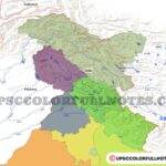
Kerala has a forest area of 11,125 square kilometres, which accounts for over 29 per cent of the state’s total land area. Kerala’s forest region is distributed over the Western Ghats, one of the world’s most biodiverse regions. It has an abundance of uncommon and endangered plant and animal species. kerala map with districts
Types of forests found in Kerala
The overall forest area in Kerala constitutes 28.90% of the state’s total land area. The forests of Kerala are essentially divided into five categories: Kerala’s wildlife and vegetation, National Parks in Kerala, Wildlife Sanctuaries in Kerala, and Wildlife Reserves in Kerala. kerala map with districts
The forests of Kerala are divided into five major categories. The following are:
- Tropical Wet Evergreen Forest
- Tropical Moist Deciduous Forests
- Tropical Dry Deciduous Forests
- Mountain Sub Tropical Forests
- Plantations
A significant portion of Kerala’s forest cover is distributed over the Western Ghats. The Western Ghats is one of the world’s 18 bio-diversity hotspots and a storehouse of unique, uncommon, and endangered plant and animal species. There are 28 types of vegetation in the state, but the existence of the majority is questionable. The southern districts account for 51 per cent of the total forest cover, while the central and northern regions account for 49 per cent. Idukki and Pathanamthitta are the districts with the most forest cover. Alappuzha is the only district that is completely devoid of forest cover.
Currently, Kerala is home to five national parks: Silent Valley National Park, Eravikulam National Park, Paampadum Shola National Park, Aanamudi Shola National Park, and Mathikettaan Shola National Park. In addition, the state has eleven wildlife sanctuaries, two bird sanctuaries, and the Periyar Tiger Reserve. Beginning in the 19th century, 75 per cent of Kerala was covered by forest; at the beginning of the 20th century, this percentage had decreased to 50 per cent. To prevent future degeneration, the majority of the forest was designated as Reserve Forest.
Kerala Climate
Kerala is situated closer to the equator than other Indian states. However, Kerala has a nice and consistent climate throughout the year. Kerala is a tropical area with a nice and consistent temperature throughout the year where one may rest and feel at peace. The monsoons (June-September and October-November) and summer (February-May) are the most prominent seasons here, but the average Winter temperature is between 28 and 32 degrees Celsius. (kerala map with districts )The typically mild atmosphere that prevails here is what our visitors appreciate the most. The rainy season is the greatest time to visit Kerala.
A temperate temperature and abundant precipitation contribute to the preservation of forest vegetation. This is the sole reason why Kerala has so many wildlife preserves. These woodlands are the perfect heaven for nature enthusiasts and other animal enthusiasts.
Kerala History
The history of Kerala is intricately intertwined with its business, which until recent times centred on the spice trade. Ancient Kerala, known as the Spice Coast of India, welcomed visitors and merchants from all over the globe, including the Greeks, Romans, Arabs, Chinese, Portuguese, Dutch, French, and British. Almost every one of them has left some kind of mark on this area. (kerala map with districts )
This has helped us shape and build our own unique method of connecting with the outside world.
The name Kerala is often interpreted to mean “the country of coconuts” since it is derived from the Malayalam word “Kera,” which means coconut. (kerala map with districts ) On 1st November 1956, the present state of Kerala was formed by the political merger of three previously distinct regions: the North Malabar region, including Tellicherry, Cannanore, and Kasargode, but excluding a small pocket of French possession; Mahe, the princely State of Cochin, forming the middle section; and Travancore, another princely State, covering the southern area.
Kerala is known for what?
Kerala is known as the Land of God in India. Kerala is renowned for its beautiful green woods, swaying coconut trees, palm-fringed beaches, captivating backwaters, and Ayurveda treatment centres, all of which are exclusive to the state.
Kerala Transportation (kerala map with districts )
Kerala has a diverse landscape throughout its length and width and is well linked to the rest of India by road, train, and air.
Kerala Airways (kerala map with districts )
Thiruvananthapuram, Kochi, and Kozhikode are the three airports in Kerala, the first two of which are international. Helicopters and air taxis are also available between Kochi and Trivandrum. However, they are more costly.
Kerala Railways (kerala map with districts )
The Indian Railways Southern Railway line connects the majority of the state’s main cities. Three divisions of Southern Railway oversee the state’s rail network: Trivandrum Railway Division, Palakkad Railway Division, and Madurai Railway Division. Kannur, Kozhikode, Shornur Junction, Palakkad Junction, Thrissur, Ernakulam Junction, Alappuzha, Kottayam, Chengannur, Kayamkulam Junction, Kollam Junction, and Thiruvananthapuram Central are the most important railway stations in Kerala.
Kerala Roadways (kerala map with districts )
The length of Kerala’s road network is about 150,851 kilometres. Local bus service is provided at regular intervals by Kerala Transport Corporation and other bus companies. These buses have been divided into four distinct categories: Standard, Fast Passenger, Super Fast, and Deluxe Express.
Kerala No. Of Districts (kerala map with districts )
All states in India share the same time zone, known as the Indian standard. Time +5:30 The Indian rupee serves as the country’s official currency. The Reserve Bank of India regulates the issue of the currency (RBI). The new sign for the Indian rupee, INR, derives from the Devanagari script. On 8th July 2011, the first set of coins with this redesigned rupee symbol was released.
The contemporary rupee is split into 100 paise; however, this division is no longer practical; as of 30th June 2011, coins with values of less than 50 paise are no longer legal tender. There are banknotes with nominal values of 5, 10, 20, 50, 100, 500, and more. The rupee is available in 1, 2, 5, and 10 coins. The nominal value of rupee paise coins is fifty, and lesser denominations have been formally discontinued. (kerala map with districts )
Kerala is split into fourteen revenue districts. They are, Alappuzha, Ernakulam, Idukki, Kannur, Kasargod, Kollam, Kottayam, Kozhikode, Malappuram, Palakkad, Pathanamthitta, Thiruvananthapuram, Thrissur, Wayanad.(kerala map with districts )
Historical Monuments/ Architecturally Significant Building/ Mansions (kerala map with districts )
Ernakulam, Idukki, and Kozhikode are among Kerala’s most important historical sites. Ernakulam is the commercial hub of Kerala and is home to several significant historical sites.
- Bastion Bungalow was constructed in the Indo-European style in the year 1667 A.D. The building has a tiled roof and a traditional wooden porch on the first floor, which runs down the front of the house.
- Chennamangalam has a synagogue for Jews. The eight-line Hebrew stone inscription indicates that the synagogue was constructed in 1615 and that one of the Jewish leaders, David Gastiline, paid for its construction. (kerala map with districts )
Idukki is yet another fascinating location in Kerala. Marayoor’s Ezhuthupara is renowned for its collection of prehistoric cave paintings. In this megalithic art collection, images are rendered in two distinct media: reddish brown soil containing multicoloured iron minerals and white clay soil.
Kozhikode is notable for Vasco de Gama. On 27th May 1498, the Vasco de Gama arrived in Kappad, a few miles north of Kozhikode. It was an event intended to etch Kerala’s name into the annals of global history. (kerala map with districts )
Kerala Hill Stations (kerala map with districts )
Munnar, PonMudi, Devikulam, and Peerumedu are some of Kerala’s most well-known hill stations.
Munnar is distinguished by the confluence of the Mudrapuzha, Nallathanni, and Kundala rivers. The region is also home to the once-every-12-years-blooming Neelakurunji plant, which is clean and pure.
Ponmudi is a picturesque and tranquil hill station located 61 kilometres from Thiruvananthapuram. It is a portion of the mountain range that runs parallel to the Arabian Sea, the Western Ghats.
Devikulam is a tiny hill station located around 16 kilometres away from Munnar in the Idukki District of the southern Indian state of Kerala. One thousand eight hundred metres above sea level.
Peerumedu is endowed with a rich past. Peerumedu is situated around 85 kilometres east of Kottayam, and its climate is pleasantly mild and humid.
Zoo/ Parks/Gardens/Jungles (kerala map with districts )
Two major zoos are located in Kerala, one in Thiruvananthapuram and the other in Thrissur. On the grounds of both zoos are museums, botanical and zoological gardens.
In 1857, the Travancore King created the Thiruvananthapuram Zoo, which occupies an area of 55 acres. The zoo was originally constructed for recreational purposes, but it was subsequently decided to preserve it. The zoo’s grounds are embellished with a variety of flora and trees. (kerala map with districts )
The Thrissur zoo was founded in 1885 at Chembukavu, Thrissur district. It has a total land area of 13 acres. This zoo’s primary objective is animal conservation, and it has implemented breeding programmes.
Kerala Wildlife Sanctuary and National Parks
Elephants, tigers, panthers, Indian bison, and Nilgiri tahr inhabit the woods of Kerala, along with other rare and wonderful species. The rare Lion-Tailed Macaque resides inside Silent Valley National Park. In addition, Kerala is home to Gaur, Spotted Deer, Sambar, the endangered Giant Grizzled Squirrel, Hanuman Langur, Sloth Bear, Flying Squirrels, jungle cat, wild boar, a variety of monkey species, Leopards, Wolves, Wild Dogs, Civet Cats, etc. The jungles of Kerala are also home to a variety of reptiles, including King Cobras, Vipers, Pythons, Rat Snakes, Cobras, several species of lizards, Turtles, and crocodiles, among others. (kerala map with districts )
Kerala is also home to several bird species, including the great and grey hornbill, darters, cormorants, mynahs, peacocks, oriels, racket-tailed and other drongoes, bulbuls, kingfishers, woodpeckers, Ceylon frogmouth, jungle fowl, parakeets, ducks, etc. In addition, several migratory birds visit Kerala annually.
Kerala has 6 National Parks and thirteen Wildlife Sanctuaries. Important national parks and sanctuaries are among them.
The Chinnar Wildlife sanctuary is situated around 60 kilometres from Munnar, on each side of the Marayoor – Udumalped road.
Eravikulam National Park is a plateau located around 30 kilometres from Munnar at an average elevation of 2100 metres. This park was initially created to safeguard the Nilgiri Tahr, which is now listed as endangered on the IUCN Red List of Threatened Species. (kerala map with districts )
The Periyar tiger reserve is one of the world’s most intriguing natural wildlife sanctuaries and one of the most prominent places in the Western Ghats.
The forestland between the Cheruthoni and Periyar rivers is occupied by the Idukki Wildlife sanctuary. Everyone is drawn to the deciduous forest by its scenic lake, towering arch dam spanning two hills, and roving elephant and gaur herds.
Kerala Palace/ Fort/Museums/Art Gallery (kerala map with districts )
Bloghatty, Alwaye, Bekal Fort, Krishnapuram Palace, Hill Palace Museum, and Kannur Fort are some of the most renowned museums, forts, and palaces in Kerala.
The Bolghatty Palace is in close proximity to Ernakulam. It was transformed into a KTDC hotel. The hotel is situated on the same-named island and is a two-story building with historical pictures gracing the walls.
On the banks of the river, Periyar stands the Alwaye palace, which has been turned into a guesthouse.
The alleged age of the Bekal Fort is 300 years. The fort was constructed mainly as a defensive building and consequently had no palace. It is believed that the Mysore army erected the ancient mosque that is located near the fort.
The Krishnapuram Palace is located 47 kilometres from Alappuzha. Today, the palace functions as an archaeological museum exhibiting Kerala’s greatest mural panels.
The Hill Palace Museum was constructed in 1865. This was the royal family’s official house in Kochi. The palace is now a Heritage Museum that shows a variety of royal artefacts, including royal furniture.
The Kannur Fort, also known as St. Angelo’s Fort, was built by a Portuguese named Don Francisco De Almeida in 1505.
Kerala Tourist Spot (kerala map with districts )
In the majority of hill stations, hiking is available, which makes seeing the Hot Spot from the hill highly intriguing.
Canoeing entails gliding through tranquil streams in a rural boat while appreciating the fresh wind and the charming sounds of various bird species. (kerala map with districts )
Kollam is located next to the renowned Ashtamudi Lake and is one of the most picturesque locations. The backwaters of Kollam are the entrance to the magnificent backwaters of Kerala, where boating is enjoyed by many.
Kerala Temples
In Kerala, the most significant temples, mosques, and churches include the Sabarimala Temple, Guruvayoor Temple, Pazhayyangadi Mosque, Mamburam Mosque, Jain Temples, and St. Mary’s Church.
- The Sabarimala Temple is situated on a Western Ghats hill. The structure is dedicated to Lord Ayyappa. Sabarimala is thought to be named after Shabari. (kerala map with districts )
- Sri Krishna Temple is at Guruvayoor. The local tradition is that the temple was built by Guru, God’s teacher, and Vayu, the God of the winds.
- The Pazhayyangadi Mosque in Kondotti, Malappuram District, is renowned for its 500-year-old Valia Nercha festival, celebrated throughout the months of February/March. Another notable mosque is the Mamburam, which is a prominent pilgrimage site and contains the tombs of renowned Thangals.
- Wayanad has Jain temples, one of which was utilised by Tippu Sultan, the king of Mysore, to keep his battery of weaponry, therefore lending the name Sultan Battery to this location in Wayanad. There are Jain temples in Kozhikode and Kasargode.
- The location of St. Mary’s Church is Kozhikode. It was established in 1860 for the collectorate. A gravestone in the neighbouring cemetery bears the date 17/17. (kerala map with districts )
- The Chottanikkara Temple, Sri Padmanabhaswamy Temple, and the Vadukkumnathan Temple are three further notable temples.
Kerala Handicraft (kerala map with districts )
Kerala has excellent handicrafts and clothing materials that may be purchased in bulk. Kerala is involved in cotton textile materials, textiles, home furnishings, upholstery fabrics, shorting, ladies’ dress materials, makeups, table linen, bed linen, fashion garments, shirts, trousers, and children’s clothing. Kerala’s handicrafts, such as Ganesh Sitting, Elephant with Decoration, and Jumping Horse, are crafted from a variety of woods, including rosewood, sandalwood, teak wood, and white wood.
Kerala Festivals (kerala map with districts )
- Kerala’s traditional arts span back thousands of years. Kathakali, Chakyarkoothu, Koodiyattam, Mohiniyattam, Krishnanattam, Patakam, and Thullal are some of Kerala’s ancient arts.
- Kathakali is Kerala’s most popular art genre. Literally, Kathakali means the narrative drama. This amazing classical dance play is based on the Natya Sastra rules.
- The genesis of the Krishnanattam dance was as a sacrifice to Sree Krishna. This dance is done in groups and is based on the Sanskrit poem Krishna Geetha.
- Mohiniyattam is yet another ancient Keralan dance. This enchantress dance mixes the beauty and elegance of Bharatanatyam with the vitality and energy of Kathakali to create a sringara-dominated atmosphere. (kerala map with districts )
- Chakyarkoothu, commonly known as Koothu, is one of Kerala’s earliest forms of classical theatre. The solo dance is often performed with the mizhavu and elathalam at the Koothambalam of temples.
- Patakam translates literally to the dissertation. Patakam and Koothu have identical technical substance, gestures, and motions.
- Koodiyattam, which literally translates to “dancing together,” is one of India’s earliest dance plays. This temple-related dance drama was chosen by UNESCO as one of the ‘Masterpieces of the Oral and Intangible Heritage of Humanity’ very recently.
- Thullal is a variant of Koothu that is distinguished by its simplicity of presentation, wit, and humour. This dance genre was created by Kunjan Nambiar, one of the foremost Malayalam poets.
- Keralan Kalaripayattu is considered the oldest and most scientific martial art in the world. Combat training is provided at the Kalari.
Kerala Biodiversity (kerala map with districts )
Western Ghats’ biodiversity is the primary component of Kerala’s biodiversity. The whole state is endowed with perpetual vegetation. Evergreen woods are its most important biological repository. Climate and soil conditions, as well as other relevant physical elements, are responsible for biological diversity. The average level of humidity in Kerala is 70 per cent. Kerala has a variety of geophysical regions, including forests, marshes, mangroves, ponds, seashores, and deltas.
The Western Ghats, which form the mountain ranges of south-western India, has been deemed a ‘Hot spot’ due to their wide range of endemic forms of biodiversity of genera, species, and races, which includes nearly 2,000 species of higher plants, 84 species of fishes, 87 species of amphibians, 89 species of reptiles, 15 species of birds, and 12 species of mammals, all of which are endemic to the Western Ghats.
Kerala Flora (kerala map with districts )
Kerala is comprised of a diversity of vegetations and forest types, despite the state’s tiny size and relatively minimal forest cover. Kerala’s forest types include Tropical Wet Evergreen Forests, Tropical Moist Deciduous Forests, Tropical Dry Deciduous Forests, Mountain Subtropical, Rolling Grasslands, Shola Forest, Thorny Scrub Forest, and high Sholas, among others. This diversity of forest types allows for the development of a vast array of vegetation. White Pine, Kuntherekka Pine, Punnappa, Bhadraksham, Palai, Vediplavu, Maravuri, Vayana, etc., are some of the trees found in the Tropical Dense Evergreen Forests. (kerala map with districts )
The Moist Deciduous Forest consists of trees like Teak, Maruthi, Karimaruthi, Rosewood, Venteak, Vengal, Chadachi, Mazhukanjiram, and Bamboo, among others. Only coniferpodocarpus wallichianus grows in the area around the Periyar Reserve. In addition to trees, hundreds of species of blooming and non-flowering plants, orchids, and medicinal plants thrive in the state’s woods.
Kerala Festivals (kerala map with districts )
In January, a 10-day yearly celebration is held at the Sreekandeswaram Temple in Thiruvananthapuram.
The week-long Nishagandhi dance event occurs in February.
- Thrissur hosts the Pooram festival in April and May. It is a flavorful food festival on the grounds of Kanakakunnu Palace.
- The annual harvest celebration starts in August and is known as Onam week Celebrations. It lasts for ten days.
- Pongala Utsavam is a yearly celebration when only ladies are permitted into the Attukal Bhagavathy Temple in Thiruvananthapuram.
- The Therayattam festival is organised to appease the gods and demons acknowledged by the Malayalis’ pantheon.
Kerala Educational Hubs
The State Cabinet has approved the establishment of a “World-Class University” in Puthur and a “Science City” between Kainur and Thrissur, making Thrissur Set a major educational centre. It is renowned as Kerala’s cultural capital. (kerala map with districts )
Kerala Hotels (kerala map with districts )
There are upscale hotels, budget hotels, and boutique hotels in Kerala. The rooms are very well-appointed with all contemporary amenities. The hotel has a business centre, recreational amenities, a doctor on call, a currency exchange, a travel desk, a swimming pool, and many bars.
These five-star hotels are present in the area:
- Taj Residency Club Mahindra Lakeview
- The Hotel Avenue Regent
- The Hotel Marari Beach Prince
Kerala Tourist Dept. Office
Numerous tourism department offices and information centres are located around the state. The full information centre gives details on the official guide facility and transportation facility. (kerala map with districts )
These are some of the key information centres:
- Thiruvananthapuram Tourist Facilitation Centre
- Kollam DTPC Tourist Information Centre
- Dept. of Tourism located at North Kumarakom.
Kerala Shopping Center
Kochi and Thiruvananthapuram are the most popular shopping destinations for all tourists. The most popular mall presets in this state are,
- Oberon Mall
- Gold Souk Grande Kochi
- Abad Nucleus Mall
- The Carmel Towers.
- Bay Pride Mall
Kerala Cinema Halls (kerala map with districts )
The Cinema of Kerala or Malayalam cinema is a subgenre of Indian cinema in which Malayalam-language films are produced in the Indian state of Kerala.
- The finest movie theatres in the area include,
- Sreekumar is an excellent cinema theatre in Trivandrum.
- Sree Padmanabha is a cinema in Trivandrum’s East Fort.
- Kairali Theater is one of the well-known theatres in Thambanoor Ajantha, a well-known hall in the Trivandrum East Fort neighbourhood.
- Trivandrum’s Ramya Theater is located near the Ayurveda College Junction.
- The Kalpana Theater may be found in Pattom. This movie theatre offers a variety of daily shows. It displays both the most recent blockbuster films and regional films.
Kerala Food Habits
These are the most popular foods in the state:
- Thorans are fried meals of finely chopped, parboiled vegetables, pork, or shellfish that lack gravy. They are marinated in mixes of coconut, chillies, mild spices, onions, and mustard seeds that have been burst.
- Avial is a thick dish of mixed vegetables. A variety of chopped and parboiled veggies are then cooked in coconut milk.
- Olen is a curry made with gourd, dry beans, and coconut milk (a favourite ingredient of Malayalee cuisine).
- Kaalan is a thick stew prepared from semi-ripe bananas from Kerala cooked in thick yoghurt and seasoned with turmeric, chilli, cumin seeds, and curry leaves.
- Pachadi is prepared by cooking vegetables in curds. It has a characteristic sour flavour. (kerala map with districts )
Safety and precautions
There are several essential aspects of a trip. It is not a choice but rather a necessary precaution that must be taken while travelling anyplace. General precautions and safety measures are,
- First aid equipment is the most crucial item that every traveller must have.
- Nighttime travel is risky.
- Keep a copy of your passport and other essential papers in a secure location.
- Never share a cab with a stranger.
- Notate the hotel’s emergency exits, stairwells, fire escapes, and emergency plans.
- Always keep the numbers for the local police and ambulance available for emergency calls.
- There are several such tourist destinations in Kerala. Each site speaks volumes about its individuality. Each tourism attraction is a source of national pride for India.