Latest Topics in News


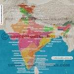
Indus river system
The Indus River system is one of the longest and most important rivers in South Asia. It originates near Mount Kailash mountains and flows eastward for 2900 kilometers before emptying into the Arabian Sea. Along its course, the river passes through some of the most rugged terrain in India and Pakistan. The river has a significant impact on regional climate, agriculture, and water resources.
Historically significant Indus valley civilisation once thrived on the banks of the Indus river. The Indus valley civilisation is one of the oldest and most significant civilisations in history. The civilisation is historically significant because it was one of the first major civilisations to develop in South Asia. The Indus valley civilisation flourished as a centre for trade and commerce between the ancient world and beyond, and its inhabitants were some of the earliest known urban dwellers. Their sophisticated drainage systems were key to their success. Today, the ruins of many of their cities remain standing testimony to their remarkable achievements.

- The Indus River rises from the Bokhar Chu (glacier) on Mt. Kailash’s northern slopes (6714m). It drains the most significant glaciers and mountain slopes, mainly in Karakoram, Ladakh, Zanskar, and the Himalayan Ranges.
- It originates on Kailash Mountain and flows in a narrow valley north-westward through Tibet, where it is known as Singi Khamban, or Lion’s Mouth. It follows a long, nearly straight course between the Ladakh and Zaskar ranges in Ladakh.
- It flows for the first 480 kilometres along the northern flank of the Zaskar range through the flat country at elevations of more than 3200 metres, where it meets the River Zaskar below Leh.
- The Shyok-Nubra tributaries join the Indus as it flows northwest. The Siachin Glacier feeds these tributaries (Karakoram Range).
- The Shigar River meets the Indus River at Skardu, a short distance below the Shyok. Gilgit is another significant tributary that joins the Indus from the west.
- Downstream, the Indus River cuts through the central Himalayan range via a massive synclinal gorge. The river flows through Nanga-Parvat before turning southwest to enter Pakistan.
Indus river system tributaries can be classified into minor and major tributaries for understanding based on the river size, So let’s cover them one by one.
Minor tributaries of river Indus in the Jammu and Kashmir are
1. Zanskar river

- The Zanskar river lies entirely in Ladakh UT, and it originates in the north-east of the mighty Himalayas in the Zanskar region,
- It is the first tributary of the Indus River in India.
2. Shyok river
- The Shyok river originates from the Siachin glacier; the Nubra river is a tributary of the Shyok river, which is a tributary of the Indus river.
- In 2019, Colonel Chewang Rinchen Bridge was constructed over the Shyok River in the Ladakh region.
3. Suru river
- The Suru river originates from the Deosai mountains and flows in the opposite direction of the Indus river; hence it is also called an obsequent tributary of the Indus river.
- Kargil is located on the banks of the suru river, and the chutak dam is over the suru river.
- Burzil la pass lies on the Suru river path.
4. Hunza river

- Hunza river flows in the Gilgit Baltistan region, presently located in Pakistan occupied Kashmir.
- Gilgit river Flows in Gilgit region , POK.
Major tributaries of Indus river system
The 5 major tributaries of River Indus are:
- Jhelum
- Chenab river
- Ravi river
- Beas river
- Sutlej river
1. Jhelum river
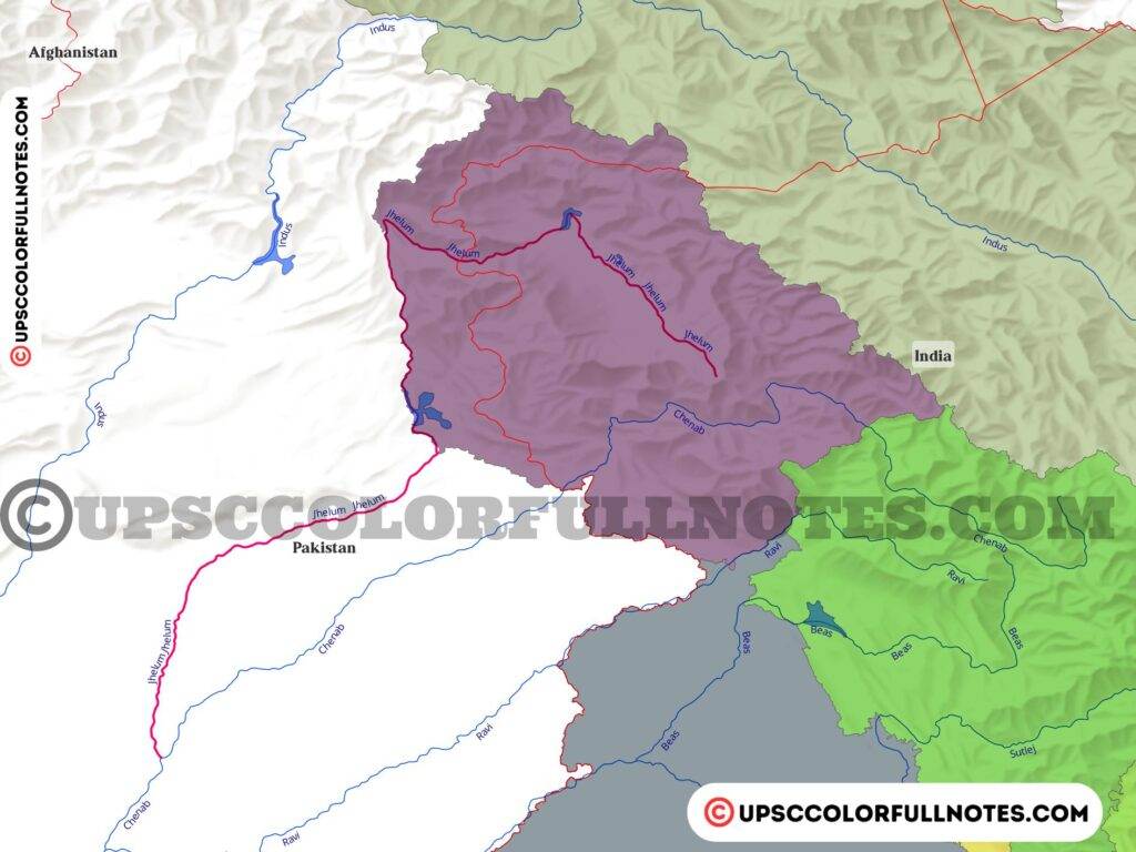
- Jhelum river originates from verinag, located in the pir-panjal range in Kashmir.
- Jhelum river is mentioned in Rigveda also as Vitasta.
- Jhelum is the lifeline of Kashmir valley peoples and also cause havoc at times due to flooding.
- Kishan Ganga river is a tributary of the Jhelum river. It was in the news recently due to Kishan Ganga hydroelectric project. Pakistan objected to the construction and went to the International Court of arbitration, but the court verdict came in favour of India.
- Jhelum river itself is a tributary of the Chenab river.
2. Chenab river
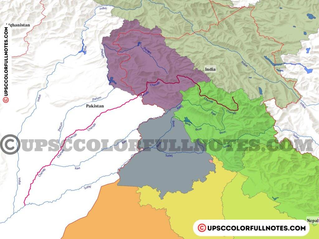
- Chenab river originates from the Zaskar range in lahul spiti, near the Bara lacha la pass in Himachal Pradesh.
- Two streams, Chandra and Bhaga, on opposite sides of bara lacha la pass, merge and form the river Chandra Bhaga also known as Chenab river.
- Originates in Zanskar range and flows parallel to pir panjal range through Pangi valley.
- Jhelum and Ravi merge with Chenab and ultimately into the Sutlej river.
- In 2021 Government of India approved the 850MW Rattle hydroelectric project on the Chenab river in the Kishtwar region of Jammu and Kashmir.
3. Ravi river
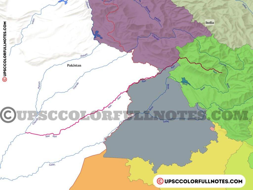
- Ravi river originates near Rohtang pass in Kullu hills, Himachal Pradesh.
- It flows in between the pir panjal range and the dhauladhar range.
- Ravi river forms the international border between India and Pakistan during its course.
- Ravi river merges with the Chenab river.
4. Beas river
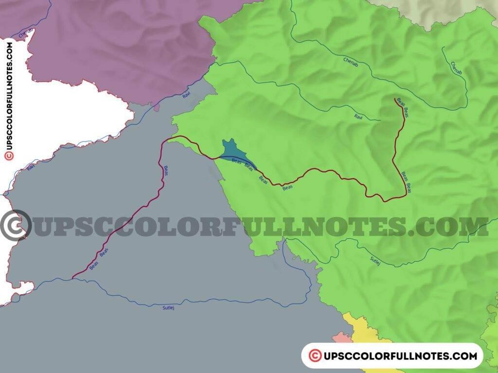
- Beas river originates from Himachal Pradesh near the Rohtang Pass at the southern end of the pir panjal range.
- It crosses the dhauladhar range and meets Sutlej at Harike in Punjab.
- It is a relatively small river and flows entirely inside Indian territory.
5. Sutlej River
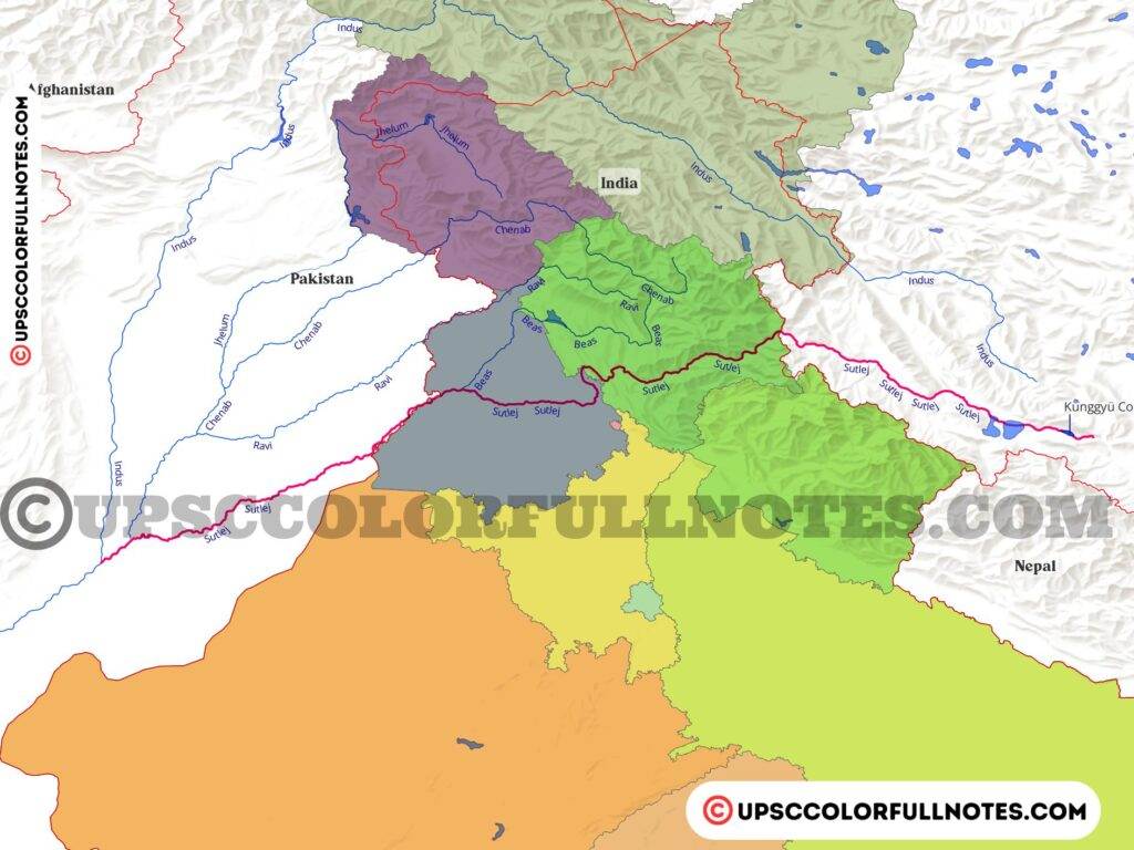
- The Sutlej river rises from Manasarovar rakas Lake in Tibet near the mighty Indus river source.
- It starts its journey northwest and enters India near the Shipki La pass on India and Tibet border.
- It passes through the great Himalayas, making deep gorges and enters the Punjab plains at Nanda Devi Dhar, where the famous Bhakra dam is constructed.
- Beas joins the Sutlej river at Harike in Punjab.
- Sutlej the river forms the international boundary between India and Pakistan during its flow in Punjab state.
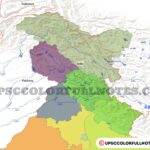
Indus river basin
- The Indus river basin extends over Tibet, India, Afghanistan and Pakistan, draining an area of 11,65,500 Sq.km. In India, the basin spreads over the states of Himachal Pradesh, Punjab, Rajasthan, Haryana and the Union Territory of Chandigarh, Jammu & Kashmir and Ladhak. The Indus River Basin covers 3,21,289 square kilometres, accounting for roughly 9.8 per cent of India’s total geographical area.
- The geographical span of the Indus river basin is between 72°28″ and 79°39′ east longitudes and 29°8″ to 36°59′ north latitudes, with a maximum length and width of 756 km and 560 km, respectively.
- The Indus river basin is surrounded on the east by the Himalayas, on the north by the Karakoram and Haramosh ranges, on the west by the Sulaiman and Kirthar ranges, and on the south by the Arabian Sea.
- The basin’s agricultural land covers 35.8 percent of its entire area, while water bodies cover 1.85 percent. The basin encompasses 32 parliamentary constituencies (2009), including 13 in Punjab, 7 in Jammu and Kashmir, 4 in Himachal Pradesh and Haryana, 3 in Rajasthan, and one in Chandigarh.
Indus Water Treaty

- Indus Water Treaty (IWT) is water distribution treaty between India and Pakistan signed on September 19, 1960
- Brokered by the World Bank (International Bank for Reconstruction and Development)
- Indus water treaty divides the Indus river system into two river systems
- Eastern Rivers- Ravi, Beas, Satluj
- Western Rivers- Indus, Jhelum, Chenab
- Treaty talks about unrestricted use of water, eastern river system has been allocated to India and western river system has been allocated to Pakistan.
- It don’t mean that India cant use western rivers water, treaty specifically mention “non-consumptive needs” which means India can use western rivers water for purposes such as electricity production, irrigation, and storage also.
- Permanent Indus Commission has been setup to manage the treaty.
- Share wise treaty allocates around 80% water of Indus river system to Pakistan
Permanent Indus Commission
- A bilateral commission of India and Pakistan officials, to manage and implement goals of the Indus Waters Treaty, 1960.
- The Commission as per treaty must meet regularly at least once a year, alternately in India and Pakistan.
Functions of the Commission
- to solve disputes arising over water sharing as per treaty.
- to observe and report to the two Governments of India and Pakistan on any problem relating to the development on the waters of the rivers.
- to host technical visits to projects’ sites and critical river head works.
- In every five years undertake a general tour of inspection of the Rivers for verifying the facts.
The Indus Water Treaty of 1960 governs the development of water resources in the Indus River system. The water of the Ravi, Beas, and Satluj rivers will be accessible for unlimited usage by India under this pact. India has also been granted permission to make non-consumptive use of runoff hydroelectric river plants and specific agricultural usage of the Indus, Jhelum, and Chenab rivers.
In conclusion, the Indus River system is an important part of the Indian subcontinent. It provides vital resources to the people and economy of the region, and it is also a source of natural beauty. The river system is home to a variety of plants and animals, and it supports a diverse array of ecosystems. It is important to protect this natural resource, and I encourage everyone to learn more about the Indus River system and its importance.


pl make a ganga,narmada,kaveri river system so that majority of the river system will cover from your notes
Every important river system will be covered ASAP. Please remain subscribed.
I have to say this ,this is one of the best sites I had ever seen. it was so difficult to learn maps through all boring maps nd seriously u made it so interesting that anyone can connect to it thankx a lot nd yeah keep doing 👍
Thanks a lot! Your words are encouraging.
Hats off to the remarkable work you have done.
Thanks a lot for the wonderfull comment!
Superb 👌
These are notes of a special quality ☑️❤️
Thanks a Lot!
Thank you for best colourfull notes ,please add ganga river system
Thanks Rajasekar! we will add Ganga river also.
Thank You, very much. This is an awesome compilation of Information. Appreciate your hard work.
Thanks a lot for these kind words! highly encouraging
You are the gem of this world. God bless you for making such wonderful notes
Thankyou for your kind words. They mean a lot to us.
SUCH A CLARIFIED INFORMATION I NEVER SEEN IN UPSC U MAKE IT JUST SIMPLE GOOD WORK
Hey Thanks for this beautiful comment- highly appreciated!
Multi purpose projects and hydroelectric projects maps and detail information please upload with colourful maps.
Its “Zanskar” not Zaskar .
Zanskar is a place name, whereas Zaskar is used for the Mountain Range!
I saw your map used in my class ppt and then I visited your website and I was really amazed that you have really done great job and it is very easier to understand.
Almost every topic is explained in very easy and creative manner which is easier for a reader to grasp.
really thanks a lot.
Thanks a lot! We are glad to be a useful resource in your journey.