Latest Topics in News


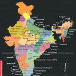
Narmada River System
The Narmada River is one of the longest rivers in India, running for over 1,312 kilometers. The river rises in the Amarkantak Plateau of the Maikala range and flows westward into the Gulf of Cambay. Along its course, the Narmada passes through the states of Gujarat, Madhya Pradesh, and Maharashtra. The river is an important source of water for irrigation and hydroelectric power generation.
Narmada river origin
The origin of Narmada is in the Amarkantak Plateau in the Maikala range, Anuppur District on Shahdol zone of eastern Madhya Pradesh at an height of 1057 meter above the mean sea level.
Narmada river
- The Narmada originates in the Amarkantak Plateau of the Maikala range in the Anuppur District on Shahdol zone of eastern Madhya Pradesh at 1057 meters above mean sea level.
- The river Narmada transverses a distance of 1,312 km before it merges into the Gulf of Cambay in the Arabian Sea near Bharuch in Gujarat.
- Detail of 1312 km. Of River Narmada
- The first 1,079 km of the Narmada run are in Madhya Pradesh.
- In the next 35 km, the Narmada forms the boundary between Madhya Pradesh and Maharashtra.
- Again, in the next length of 39 km, it forms the boundary between Maharashtra and Gujarat.
- The last length of 159 km of river Narmada lies in Gujarat.
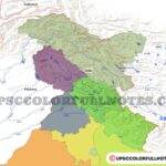
- The Narmada river basin encompasses an area of 98,796 sq. Km.
- The Narmada basin is bounded on all side by various hill ranges.
- the north by the Vindhyas,
- on the east by the Maikala range
- on the south by the Satpuras and
- On the west side of Narmada lies the Arabian Sea.
- Most of the Narmada River basin is less than 500 meters above mean sea level.
- Only a tiny area around Panchmarhi is at an elevation of more than 1,000 meters above mean sea level.
- Drainage area spread
- Madhya Pradesh 85,859 sq. Km.
- Maharashtra 1,538 sq. Km.
- Gujarat 11,399 sq. Km.
Climate
- The climate of the Narmada basin is tropical humid and varies from sub-humid in the east to semi-arid in the west, along with pockets of humid climates around higher hill reaches in the basin.
- The Tropic of Cancer crosses the Narmada basin in the upper plains area, and most of the basin lies below this line.
- The climate of the Narmada basin is tropical and humid, and
- Four distinct seasons occur in this basin, which are: (i) cold weather, (ii) hot weather, (iii) south-west monsoon and (iv) post-monsoon.
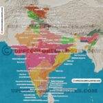
Tributaries of Narmada river

narmada river tributaries – left and right bank tributaries of narmada
- Narmada River has 41 tributaries. Of these, 22 are on the left bank and 19 on the right.
- The important tributaries/sub-basins of the Narmada are discussed one by one below.
Burhner river

- The Burhner river is the left bank tributary of the Narmada river with a catchment area of 4118 sq. km.
- The Burhner river originates in the Maikala range, south-east of the Gwara village in Mandla district of Madhya Pradesh at an elevation of 900 meters.
- Burhner flows for 177 km to join Narmada river at its 248 km run from source.
Chhota Tawa River

- The Chhota Tawa River is a left-bank tributary of the Narmada River.
- It originates in the Satpura range in the west Nimar District of M.P. near to the Kakora village.
- Chhota Tawa River flows for a length of 169 km in a northeastern direction to merge into the Narmada River at its 829 km run from source to the north of Purni village.
- The Chhota Tawa river is next in size to the Tawa river among the left bank tributaries of the Narmada river and drains a total area of 5,051 sq. km.
- The climate of the Chhota Tawa basin is humid and tropical.
- South-west monsoon from June to September accounts for 88% of the average annual rainfall for the Chhota Tawa sub-basin.
Dudhi River
- The Dudhi River is a left-bank tributary of the Narmada River.
- Dudhi River rises in the Mahadeo Hills of the Satpura range, west of the Chhindi village, Chhindwara district, M.P., at 900 m.
- Dudhi River flows for a total length of 129 km to merge into the Narmada River at the North-west of Nibhora at a distance of 575 km run from the source.
- It drains an area of 1,541 sq. km.
Ganjal river
- The river Ganjal origin is in the Satpura hill ranges of the district Betul of Madhya Pradesh, to the north of the Bhimpur village at the height of 800 m.
- The Ganjal River runs for a length of 89 km north-westerly to join the Narmada near the Chhipaner village.
- The Morand River is a tributary of the Ganjal River and merge into it just upstream of Chhidgaon and has a length of about 121 km.
Goi River
- The Goi River is a left-bank tributary of the Narmada River.
- Goi river rises in the Satpura hill ranges, near village Dhavdi, in west Nimar District of Madhya Pradesh, at 600 m.
- Goi river runs for a total length of 129 km to join the Narmada River west of Barwani village at a distance of 1,038 km from the source.
- Goi river drains a total area of 1,891 sq. km.
Hiran River

- Hiran River originates in the Bhanrer range in the Jabalpur district of Madhya Pradesh near the Kundam village at the height of 600 m.
- Hiran River flows in a generally south-westerly direction for a length of 188 km to merge into the Narmada river from the right near Sankal village.
- Hiran river has the distinction of being the biggest right bank tributary of the Narmada river, and it drains an area of 4,792 sq. km.
- The Hiran river sub-basin covers part of the areas of Jabalpur and Damoh Districts of M.P.
Karjan river

- The Karjan river is a left-bank tributary of the Narmada River.
- Karjan rises in the Satpura hill ranges in the Surat district to the south of Nana village at the height of 300m.
- Karjan river runs for 93 km to join the Narmada River in the east of the Sinor village at 1,199 km run from source.
- It drains an area of 1,489 sq. km.
Kolar River
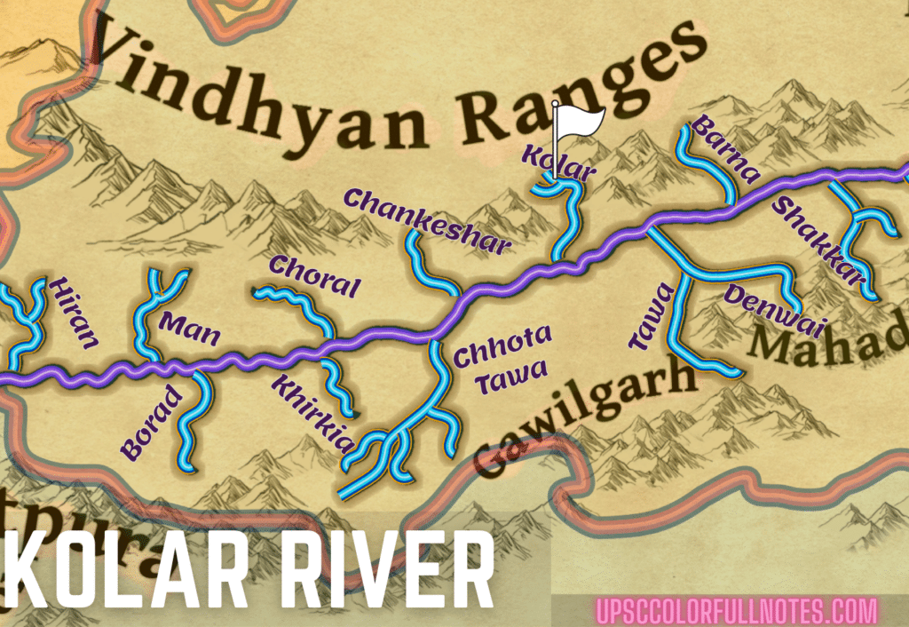
- The Kolar river originates in the Vindhyachal hill ranges in the Sehore district of Madhya Pradesh near the Bilqisganj village at the height of 550 m.
- Kolar runs for a total length of 101 km in a south-westerly direction to join the Narmada river from the right to the south of Nasrullahganj.
- Kolar river drains an area of approx. 1,347 sq. km. During its course.
- The Kolar river sub-basin is located in the two districts, Sehore and Raisen.
Kundi river
- The Kundi River is a left bank tributary of Narmada River, which originates in the Satpura hill ranges in the west Nimar District of Madhya Pradesh near the Tinshemali village height of 600m.
- It runs for a length of approx. 121 km and merge into the Narmada River near the Mandleshwar, a distance of 943 km run by river Narmada from its source.
- Kundi river drains an area of 3,820 sq. km.
Orsang River
- The Orsang river rises in the Vindhya hill ranges of the Jhabua district of Madhya Pradesh, near the Bhabra village, a height of 300 meters.
- Orsang river runs for about 101 km in a south-westerly direction to merge into the Narmada river from the right, near Chandod.
- Orsang drains a total area of 4,079 sq. Km. and is next in size to the Hiran river amongst the right bank tributaries.
Sher river
- The Sher river originates in the Satpura range near Patan in the Seoni district of Madhya Pradesh at the height of 600 meters.
- Sher river flows in a north-westerly direction for a length of 129 km. It meets the Narmada river from the left side near the Brahmand.
- The Sher river drains an area of approx. 2,901 sq. km.
- Sher river sub-basin lies in the Narsimhpur, Chindwara and Seoni districts in Madhya Pradesh. It consists of hilly terrain, which is heavily intersected by streams and rivers.
- The vegetation of the Sher basin is identified by the forest of medium density, scrubland, pockets of cultivation on undulating land and some denuded land.
Tawa river

- The Tawa river is the biggest left bank tributary of the Narmada river,
- Tawa river originates in the Mahadeo Hills of the Satpura ranges in the district Chhindwara of Madhya Pradesh near the Cherkathari village at the height of 900 m.
- Taw River runs in a generally north-westerly direction for 172 km to merge into the Narmada river from the left to the northeast of Hoshangabad.
- The Denwa river is its important tributary.
- The Tawa river drains an area of 6,333 sq. km.
- Tawa dam has been built over the river Tawa in its catchment.
Tendoni River
- The Tendoni River is the right bank tributary of river Narmada.
- It rises in the Vindhya hill ranges in the Raisen District of Madhya Pradesh near the Sodarpur village at the height of 600 m.
- Tendoni runs for a length of 118 km to merge into the river Narmada near Bhatgaon village, a distance of 602 km run from Narmada source of origin.
- Tendoni river drains a total area of 1,632 sq. km.
Uri River
- The Uri River is the right bank tributary of river Narmada.
- Uri river originates in the Vindhya hill ranges in the Jhabua district of Madhya Pradesh near the Kalmore village at the height of 450 m.
- Uri river runs for a length of approx. 74 km to merge into the Narmada River at a distance of 1,029 km run from river Narmada source.
Narmada river map
In conclusion, the Narmada River is an important part of India and its history. The river system provides water for drinking, irrigation, and transportation. It is also a source of hydroelectric power. The Narmada River is an important resource for the people of India.
FAQ
Narmada river flows through which states
Narmada river flows through three states Madhya Pradesh, Maharashtra and Gujrat. The Narmada River transverses a length of 1,312 km beginning from Amarkantak and consolidating To Gulf of Cambay.
Origin of river Narmada
Narmada river originates in the Amarkantak Plateau of Maikala range in the Anuppur District on Shahdol zone of eastern Madhya Pradesh at an height of 1057 meters above mean sea level.
Narmada river length
The
Narmada River transverses a distance of 1,312 km Before it merge into Gulf of Cambay in the Arabian Sea near Bharuch in state of Gujarat.
The river Narmada falls into the ?
The Narmada River transverses A length of 1,312 km before it merge into Gulf of Cambay in the Arabian Sea near Bharuch in state of Gujarat.
In conclusion,the Narmada River System is a key water source for the people of India. It is also a vital part of the country’s ecosystem. The river provides water for irrigation, drinking, and industry. It also supports a diversity of plant and animal life. The Narmada River System is an important part of India’s natural heritage and it is essential to protect it for future generations.
Sardar Sarovar Dam
- The Sardar Sarovar Dam is a concrete gravity dam erected on the Narmada River near the town of Kevadiya in Gujarat’s Narmada District.
- The dam was built to supply water and power to four Indian states: Gujarat, Madhya Pradesh, Maharashtra, and Rajasthan.
- The dam is located on the boundary between Gujarat and Maharashtra in Gujarat’s Narmada district.
- To the west of the dam lies the Malwa plateau of Madhya Pradesh, where the Narmada river cuts through the hill regions and culminates in the Mathwar hills.
- The dam irrigates drought-prone areas in Gujarat and dry portions in Rajasthan’s Barmer and Jalore districts.
- The dam also protects 210 villages and the city of Bharuch from flooding.
- Saurashtra Narmada Avtaran Irrigation is a significant scheme that will assist irrigate several areas with canal water.
More about Narmada basin here


Never seen such incredible aesthetic website. Bookmarked it. Will share with friends also. Keep it up.❤
Thanks a lot!
Really awesome brother, bhai ye add hata do, to ye website, world ka best website hoga, one of the most, beautiful, awesome, in the world, jovi bolo kam par jayega! Thank’s bro
Hey Mehebub, apka teh dil se shukriya itni jabardast tarif ke liye. Ads se thoda bohat paisa jo atta hai wo server costs mein laga diya jata hai. Jaise hi koi dusra monetisation source hoga ads hata diye jayenge. Ek bar fir se apka shukriya!
thanks bhai ….. adha kaam kam kar diya yaha se mera quick revision hogaya… best website came across…keeep going your work is helping alot of aspirants
Thank you so much, Nehal, for your sweet words! They motivate us and help us keep going.
Ma’am Naramada river originates from Amarkantak in Anuppur district not Shahdol please Edit ! Thankyou
Hey Mr. Singh! Actually its Anuppur District on Shahdol zone of eastern Madhya Pradesh. Thanks for pointing out! post is updated