Latest Topics in News


The Bab el-Mandeb Strait is a narrow yet strategically vital maritime chokepoint connecting the Red Sea and the Gulf of Aden. Located between Yemen and Djibouti/Eritrea, this critical channel controls access to the Suez Canal and the inland trade routes of the Red Sea region. This article comprehensively covers the geographical dimensions of the Bab el-Mandeb Strait before analyzing its strategic economic importance as both a global oil transit chokepoint and critical link in trade flows between Europe, Asia and Africa. The geopolitical dynamics around Bab el-Mandeb are also explored, including the impact of the Yemen conflict, roles of regional players and military presence of external powers.
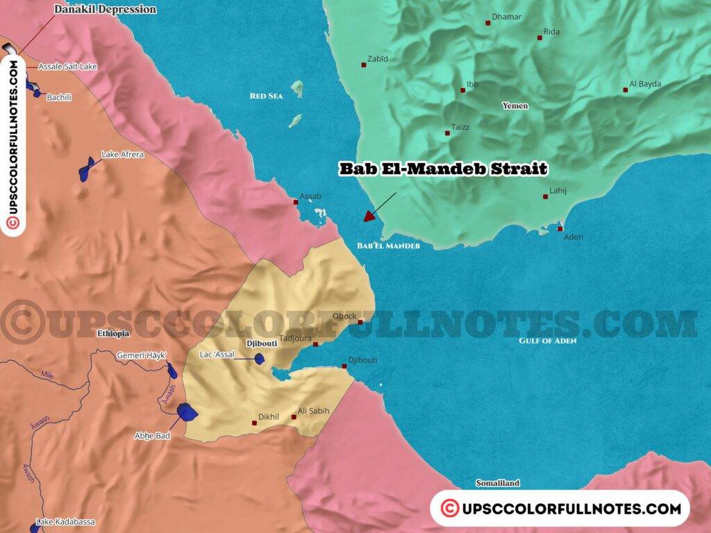
What is the Bab el-Mandeb strait?
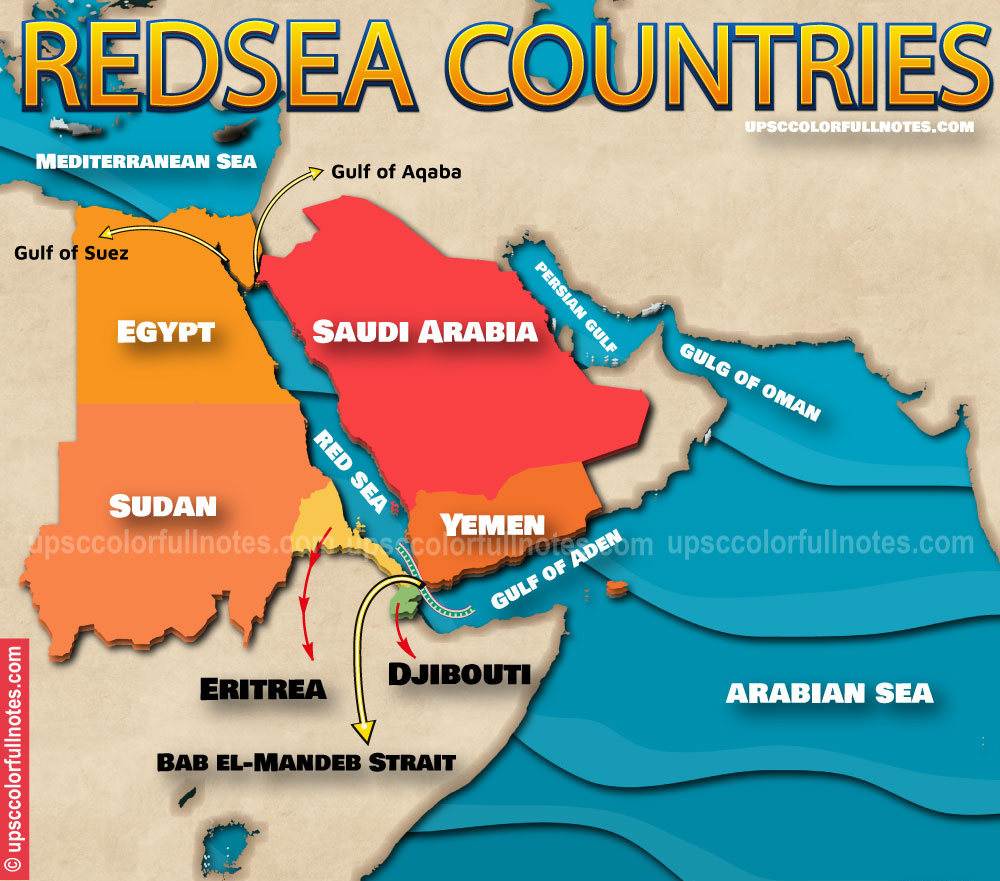
The Bab el-Mandeb is a strait connecting the Red Sea to the Gulf of Aden and the Indian Ocean, located between Yemen on the Arabian Peninsula and Djibouti and Eritrea on the African coast. It is called the “Gate of Tears” in Arabic language, referring to the dangers of navigating through this strait historically. The Bab el-Mandeb forms a vital strategic link in the maritime trade route between the Mediterranean Sea and Indian Ocean via the Red Sea and Suez Canal.
Where is the Bab el-Mandeb strait located?
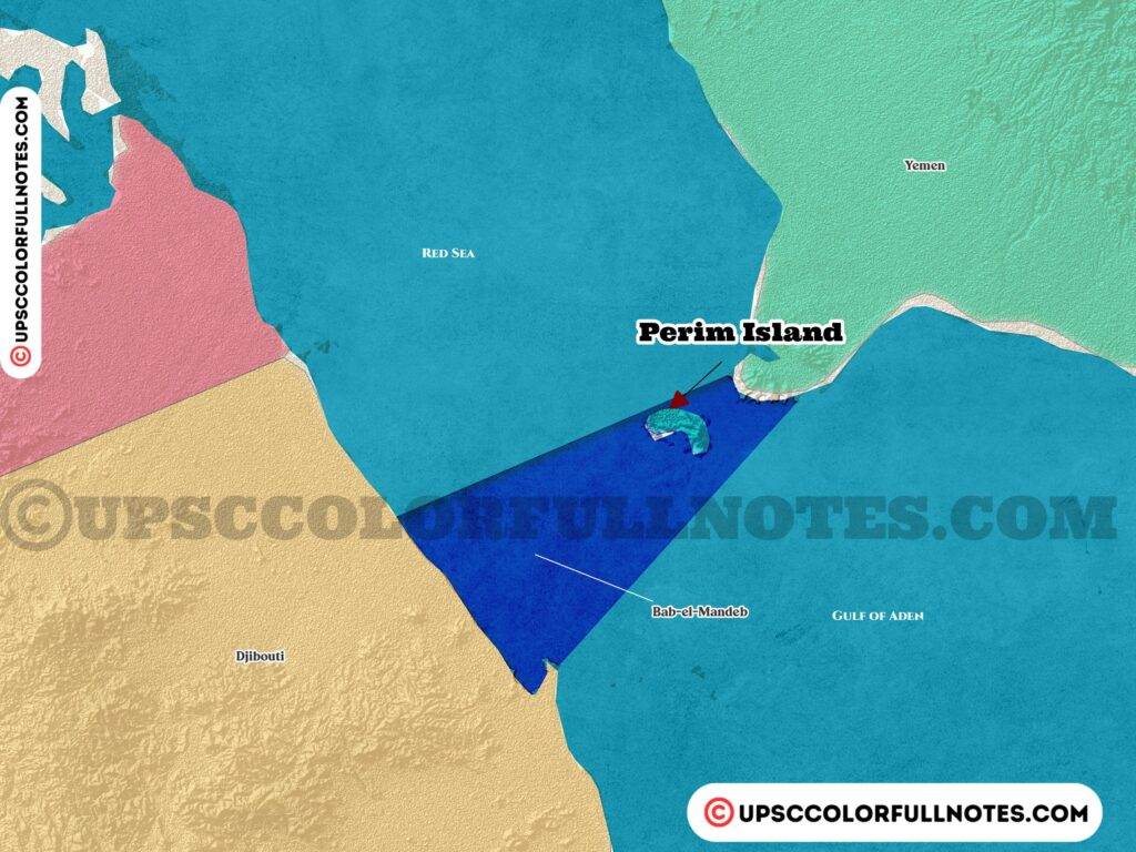
Geographically, the Bab el-Mandeb strait is situated between Northeast Africa and West Asia. Countrywise, it is bordered by Yemen on the Arabian Peninsula side and Djibouti and Eritrea on the Horn of Africa side. The strait is 50 km or 31 mi long at its widest point between Ras Menheli (Yemen) and Ras Siyan (Djibouti). It contains the Seven Brothers islands near the African coast. The geographical coordinates of the Bab el-Mandeb Strait are approximately 12.583°N latitude and 43.333°E longitude
Dimensions of Bab el mandab strait
The Bab el-Mandeb Strait, located between Yemen on the Arabian Peninsula and Djibouti and Eritrea in the Horn of Africa, has the following dimensions:
- Max. length: 31 miles (50 km)
- Min. width: 16 miles (26 km)
- Average depth: 609 feet (186 m)
The Bab el-Mandeb Strait is 20 miles (32 km) wide and is divided into two channels by the Perim Island also known as Mayyun Island which is a volcanic island located in the Strait, off the southwestern coast of Yemen; The divided western channel of Bab el-Mandeb Strait is 16 miles (26 km) wide, and the eastern channel is 2 miles (3 km) wide.
The Bab el-Mandeb strait is 18 miles wide at its one of the narrowest point between Yemen and Djibouti. This limited width constraints the passage of maritime traffic and essentially “chokes” the strait, limiting vessels and making navigation difficult.
What countries border the Bab el-Mandeb strait?
The countries directly bordering the Bab el-Mandeb strait are Yemen on the Arabian Peninsula side and Djibouti and Eritrea on the Horn of Africa side. In addition to these three countries, there are several small islands that dot the strait such as the Perim Island and Seven Brothers islands near the African coast.
Why is the Bab el-Mandeb called the “Gate of Tears”?
The Bab el-Mandeb strait’s name in Arabic translates to “Gate of Tears”. This name refers to the dangers involved historically in navigating through the narrow strait. There is also an Arabic legend that it got this mournful name after many people drowned when an earthquake separated the Arabian peninsula from Africa.
Climate of Bab el-Mandeb strait
The climate in the Bab el-Mandeb Strait region is hot and dry, with less than 100 mm of precipitation falling annually. The maximum temperatures can reach up to 33°C, although the mean temperature is around 27°C.
What is the water temperature in the Bab el-Mandeb Strait?
The water temperature in the Bab el-Mandeb Strait ranges between 25 and 31 °C (77 and 88 °F). The surface temperatures of the Gulf of Aden’s waters are generally within this range.
What is the salinity level of the water in the Bab el-Mandeb Strait?
The salinity level of the water in the Bab el-Mandeb Strait is approximately 39.7 practical salinity units (psu). During winter, the deep outflow entering the strait at Hanish has salinities of 40.5-40.65 psu, which is essentially undiluted Red Sea deep water. The Red Sea Water enters the Gulf of Aden through the Bab el-Mandeb Strait as a dense current and spreads into the Gulf.
Where is the Bab el-Mandeb Strait located geologically?
The Bab el-Mandeb Strait is located on the divergent boundary between the African Plate and the Arabian Plate. This boundary is also known as the Red Sea Rift, and it is a younger parallel of older mid-ocean ridges like the Atlantic and Pacific ridges.
How and when was the Bab el-Mandeb Strait formed?
The strait was formed due to paleo-environmental and tectonic events in the Miocene epoch around 23-5.3 million years ago. These events created the Danakil Isthmus, which was a land bridge between Yemen and Ethiopia.
How can the plate tectonics of the Bab el-Mandeb region be described?
The present-day plate kinematics of the Bab el-Mandeb region can be described accurately by a network of four plates (Arabia, Somalia, Sinai, and Danakil) and six triple junctions where three plates meet.
Why is the Bab el-Mandeb strait strategically important?
The strategic importance of the Bab el-Mandeb strait is due to it forming a vital link in the maritime trade route connecting the Mediterranean Sea and the Indian Ocean via the Red Sea and Suez Canal. About 9% of total seaborne-traded oil passed through the strait in 2017, highlighting its significance as an oil transit chokepoint. The Bab el-Mandeb is one of the world’s busiest shipping lanes enabling trade flows between Europe, Asia and Africa. Its location controls access to the Suez Canal and SUMED pipeline.
What major oil routes pass through the Bab el-Mandeb?
Most exports of oil and natural gas from the Persian Gulf that transit the Suez Canal or SUMED Pipeline pass through the Bab el-Mandeb strait. It is a critical chokepoint for energy shipments heading to Europe and North America. Specifically, around 6.2 million barrels per day (b/d) of oil flowed north through the strait towards Europe in 2018, up from 5.1 million b/d in 2014. Another 2.6 million b/d passes south through the strait to Asian markets.
How does the Yemen conflict impact the Bab el-Mandeb?
The ongoing civil war in Yemen involves Houthi rebels who have frequently targeted commercial and military vessels passing through the Bab el-Mandeb strait, as recently as late 2023. This threatens freedom of navigation through this chokepoint. Disrupting or blocking the strait impact oil shipments and global energy supplies.
What role do regional powers play in the Bab el-Mandeb?
Regional rivals Saudi Arabia and Iran are engaged in a power struggle that has extended to the countries around the Bab el-Mandeb strait. Other regional actors like the UAE, Egypt, Turkey and Gulf states have growing economic and military interests in ports and bases near the strait to project influence.
Do the US and China have military bases by the Bab el-Mandeb strait?
Yes, both the US and China have military bases located in Djibouti near the Bab el-Mandeb Strait.
The US military base in Djibouti is called Camp Lemonnier. It is located next to Djibouti–Ambouli International Airport in Djibouti City and is operated by the US Navy.
China opened its military base in Djibouti in May 2018 called the Chinese People’s Liberation Army Support Base. While the US has had a presence in Djibouti since 2002, China’s base there is relatively new.
Both countries have bases in Djibouti due to its strategic location close to the Bab el-Mandeb Strait, which serves as a vital link in global trade routes.
Final Thoughts
As highlighted in this in-depth analysis, control of narrow Bab el-Mandeb strait situated between the Arabian Peninsula and the Horn of Africa has long been deemed as highly strategic due its location along critical global trade routes. Situated between the Yemen on the Arabian Peninsula side and Djibouti and Eritrea on the Horn of Africa side this maritime chokepoint have a geat influence on energy security, regional relations and worldwide trade flows.