Latest Topics in News


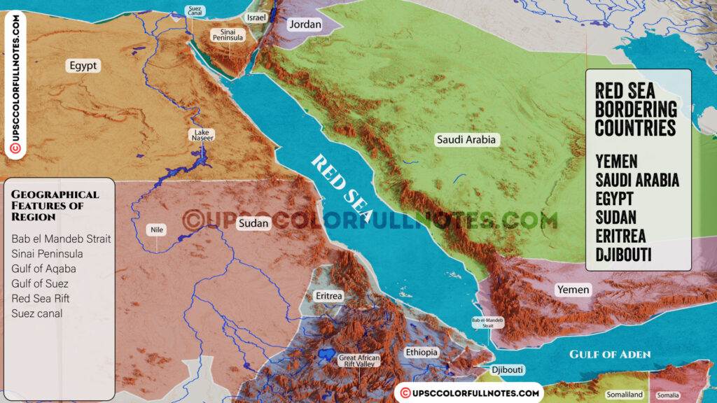
Red sea
Red sea and Red Sea Countries.
The Red Sea is a narrow strip of water that lies between the continents of Africa and Asia, connecting the Mediterranean Sea to the Indian Ocean. With its crystal-clear waters and vibrant marine life, the Red Sea is a popular destination for tourists and divers alike. But it’s not just a beautiful body of water – it’s also home to six countries that border its shores, each with its own unique culture, history, and traditions.
From the deserts of Saudi Arabia and Sudan to the ancient ruins of Egypt and the bustling ports of Djibouti and Eritrea, the Red Sea countries offer a diverse and fascinating array of sights and experiences. In this article, we’ll take a closer look at each of these six nations, their geographic location, and their relationship to the Red Sea.
- Red sea extends from Bab el-Mandeb Strait to Gulf of Suez,
- length 1930 km approx.
- Red sea is actually a part of the Great Rift Valley of Africa
- North of REDSEA- Gulf of Aqaba, Gulf of Suez (leading to the Suez Canal), Sinai Peninsula.
- South of REDSEA- Bab el Mandeb strait, Gulf of Aden.
- Red Sea is one of the most heavily travelled waterways on the globe, carrying maritime traffic between Europe and Asia.
Red Sea Map
Countries Bordering the Red Sea Proper
| Eastern Shore | Western Shore |
|---|---|
| Saudi Arabia | Egypt |
| Yemen | Sudan |
| Eritrea | |
| Djibouti |
Countries Bordering the Gulfs of Aqaba and Suez
| Gulf | Countries |
|---|---|
| Gulf of Aqaba | Egypt, Israel, Jordan, Saudi Arabia |
| Gulf of Suez | Egypt |
Red Sea – Basic Information
| Parameter | Description |
|---|---|
| Location | Between Africa and Asia |
| Connection to the ocean | Bab el Mandeb Strait and the Gulf of Aden |
| Northern boundary | Sinai Peninsula, Gulf of Aqaba, and Gulf of Suez |
| Surface area | 438,000 km2 (169,000 sq mi) |
| Length | 2,250 km (1,400 mi) |
| Width | 355 km (221 mi) |
| Average depth | 490 m (1,610 ft) |
| Maximum depth | 3,040 m (9,970 ft) |
| Shallow shelves | Extensive with abundant marine life and corals |
| Invertebrate species | Over 1,000 |
Red Sea – Extent
| Limits | Description |
|---|---|
| Northern limits | Southern limits of the Gulfs of Suez and Aqaba |
| Southern limits | A line joining Husn Murad and Ras Siyyan |
Physical Characteristics of the Red Sea
| Characteristic | Details |
|---|---|
| Location | Between arid land, desert, and semi-desert |
| Reef systems | Better developed due to greater depths and efficient water circulation pattern |
| Water mass-exchanges | Arabian Sea, Indian Ocean via Gulf of Aden |
| Salinity | Ranges from ~36 ‰ in the south to 41 ‰ in the north with an average of 40 ‰ |
| Geology | Formed by the Arabian peninsula being split from the Horn of Africa by movement of the Red Sea Rift |
Why Redsea is called Redsea?
- Normally, the Red Sea is an intense blue-green
- However, it is populated by extensive blooms of the algae Trichodesmium erythraeum occasionally, which, upon dying off, turn the sea a reddish brown colour, which gives it the name Redsea.
Red Sea – Names
| Name | Description |
|---|---|
| Erythra Thalassa | Greek name meaning Red Sea |
| Erythraean Sea | European name for the Red Sea |
| Mare Rubrum | Latin name meaning Red Sea |
| Sinus Arabicus | Latin name meaning Arabian Gulf |
| Pontus Herculis | Roman name meaning Sea of Hercules |
| Al-Baḥr Al-Aḥmar | Arabic name meaning the Red Sea |
| Baḥr Al-Qulzum | Arabic name meaning the Sea of Clysma |
| ⲫⲓⲟⲙ ̀ⲛϣⲁⲣⲓ | Coptic name meaning the Red Sea |
| ܝܡܐ ܣܘܡܩܐ | Syriac name meaning the Red Sea |
| Badda cas | Somali name for the Red Sea |
| Qeyyiḥ bāḥrī (ቀይሕ ባሕሪ) | Tigrinya name for the Red Sea |
Climatic Characteristics of the Red Sea
| Characteristic | Details |
|---|---|
| Monsoon seasons | Northeasterly and southwesterly monsoons |
| Temperature | Average surface water temperature during summer is about 26 °C (79 °F) in the north and 30 °C (86 °F) in the south |
| Rainfall | Extremely low, averaging 60 mm (2.36 in) per year |
| Salinity | High due to excess evaporation, as high as 2,050 mm (81 in) per year |
| Coral reefs | Healthy with much fish life and very little sign of coral bleaching, with only 9% infected by Thalassomonas loyana, the ‘white plague’ agent |
The six countries bordering the Red Sea are
- Yemen
- Saudi Arabia
- Egypt
- Sudan
- Eritrea
- Djibouti

The Red Sea – A Geostrategic and Resource-Rich Region Facing Security Threats
With its location connecting three continents, the Red Sea holds substantial geopolitical importance. It serves as a vital shipping passage between Europe and Asia. The surrounding nations like Egypt, Saudi Arabia, and Eritrea further add to its strategic value.
Beyond politics, the Red Sea region also brims with natural riches like oil, gas, coral reefs, and abundant marine life. These resources contribute to its economic potential.
However, serious security challenges plague the area. Piracy and terrorism emanating from the Horn of Africa remain persistent threats. Moreover, rising tensions between Iran and the US have led to a military buildup in the region’s waters.
So while the Red Sea region is strategically important and resource-rich, it continues to face security issues that must be addressed through cooperation. Its geopolitical significance, natural wealth, and volatile status make the Red Sea a crucial region to understand.
Download Red sea countries Map
In conclusion, the Red Sea countries are a fascinating and important region with a rich history and diverse culture. The countries that share its coastlines have played significant roles in global trade, politics, and international relations. From the ancient civilizations that flourished along its shores to the modern ports and economic hubs that have grown in recent years, the Red Sea countries continue to be a vital area for the world. Its strategic location, valuable resources, and unique ecology make it a key region for scientific research, environmental protection, and sustainable development.