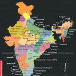
Latest Topics in News

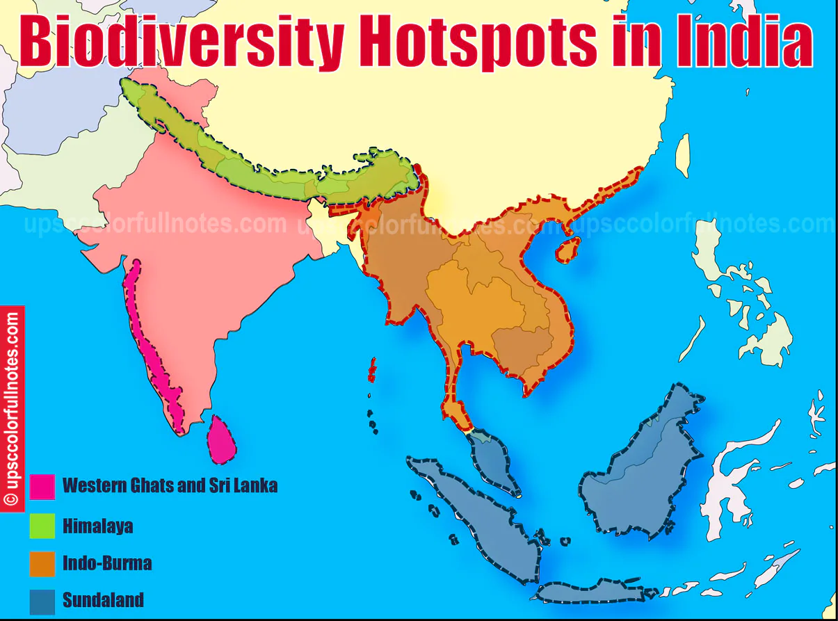


Biodiversity Hotspots in India are four in number. Across the world, 36 areas qualify as Biodiversity hotspots. They account for just 2.4% of Earth’s land surface, but they hold up more than half of the world’s plant species as endemics ( i.e., species found no place else) and nearly 43% of bird, mammal, reptile and amphibian species as endemics.
Few Facts
How many biodiversity hotspots in India?
There are four biodiversity hotspots in India:
Himalaya
Indo-Burma
Sundalands
Western Ghats and Sri Lanka
What are biodiversity hotspots?
To qualify as a Biodiversity Hotspot a region must meet these two strict criteria:
1. The place must have at least 1,500 vascular plants as endemic to it. Such a place must have a high percentage of plant life found nowhere else on the Earth. So a hotspot is an irreplaceable region.
2. It must have a surviving population of 30% or less of its original natural vegetation. Or we can say that it must be a threatened region.
Who declares Biodiversity hotspots?
Conservation International a pioneer in defining and promoting the concept of hotspots. Formed in 1989, just one year after scientist Norman Myers wrote the paper that introduced the hotspots concept, Conservation International adopted the idea of protecting these incredible locations.
Is Conservation International an NGO?
Conservation International is an American NGO headquartered in Virginia. Formed in 1987, it strives to protect our environment by acknowledging Biodiversity Hotspots around the world.
Table 1: History of Biodiversity Hotspots
| Year | Event |
|---|---|
| 1988 | British ecologist Norman Myers published a seminal paper identifying 10 tropical forest “hotspots” |
| 1989 | Conservation International adopts Myers’ hotspots as its institutional blueprint |
| 1996 | Conservation International undertakes a reassessment of the hotspots concept and designates 25 |
| 2005 | An additional analysis designates 34 hotspots based on the work of nearly 400 specialists |
| 2011 | Forests of East Australia is identified as the 35th hotspot |
| 2016 | North American Coastal Plain is recognized as the Earth’s 36th hotspot |
Table 2: Features for Biodiversity Hotspots
| Features | Explanation |
|---|---|
| 1,500 species of vascular plants | An area must have at least 1,500 species of vascular plants found nowhere else on Earth |
| Have lost at least 70% of its primary native vegetation | An area must have lost at least 70% of its primary native vegetation |
| 36 zones | Globally, 36 zones qualify under this definition |
| 60% of the world’s plant, bird, mammal, reptile, and amphibian species | These sites support nearly 60% of the world’s plant, bird, mammal, reptile, and amphibian species |
| Host their diverse ecosystems on just 2.4% of the planet’s surface | Biodiversity hotspots host their diverse ecosystems on just 2.4% of the planet’s surface |
Biodiversity Hotspots in India.
| Name of Hotspot | Hotspot Original Extent (km²) | Endemic Plant Species No. | Endemism (%) | |
|---|---|---|---|---|
| 1 | HIMALAYA Hotspot | 741,706 | 3,160 | 31.6 |
| 2 | INDO-BURMA Hotspot | 2,373,057 | 7,000 | 51.9 |
| 3 | SUNDALAND Hotspot | 1,501,063 | 15,000 | 60.0 |
| 4 | WESTERN GHATS AND SRI LANKA Hotspot | 189,611 | 3,049 | 51.5 |

Now let’s checkout the 4 Biodiversity Hotspots in India
Himalaya Hotspot
- Hotspot Original Extent- 741,706 km²
- Himalaya Hotspot consists entire Indian Himalayan region along that falling in Pakistan, Tibet, Nepal, Bhutan, China and Myanmar.
- Himalaya Hotspot stretches in an arc over 3,000 km.
- Himalaya Hotspot endowed with the world highest mountain includes all of the world mountain peaks that are higher than 8,000 meters counting Mt. Everest.
- The Himalayan Mountains ranges from less than 500 m to more than 8,000 meters which creates a diversity of ecosystems that are:
- It contains Alluvial grassland among the tallest in the world.
- Subtropical broadleaf forests along the foothills
- Temperate broadleaf forests in the mid-hills,
- It has Mixed conifer and conifer forests in the higher ranges.
- Himalayan Mountains ranges have Alpine meadows above the tree line.
- Biogeographically the Himalayan Mountain Range lies between the Palearctic and Indo-Malayan realms. Species from both these realms exist in this hotspot.
Flora
Plants that make this area a Biodiversity Hotspot are
- There are an estimated 10,000 species of plants in this hotspot with about 3,160 endemics.
- The large scale family of flowering plants in this hotspot is the Orchidaceae having 750 species.
- Five plant families that are endemic to Himalaya hotspot are
- Tetracentraceae
- Hamamelidaceae
- Circaesteraceae
- Butomaceae
- Stachyuraceae.
- The Himalaya Hotspot have a zone of permanent rock and ice that begins at about 5,500–6,000 meters. Despite these harsh climate, there is evidence of vascular plants occurring at some of the highest elevations on Earth.
Fauna
- The famous western Tragopan is found here, having plumage shades of blue, black, crimson and brown speckled with white. The male Tragopan shows off during courtship by erecting two blue horn-like feathers and inflating its purple throat.
- In the upper reaches of the Himalaya Hotspot roams the solitary snow leopard whose favourite prey is the Ibex and bharal.
INDO-BURMA Hotspot
Hotspot Original Extent 2,373,057 km²
Geographical Extent
- The Indo-Burma hotspot in tropical Asia positioned to the east of the Ganges Brahmaputra lowlands.
- The Indo Burma hotspot also contains the Lower Mekong river catchment area.
- It starts in eastern Bangladesh then extending across north-eastern India to the south of the Brahmaputra River.
- It encompasses nearly all of Myanmar, parts of south and west Yunnan Province in China, the whole of Lao People’s Democratic Republic, Cambodia and Vietnam, and a vast majority of Thailand and a small part in Peninsular Malaysia.
- The Indo Burma hotspot includes the coastal lowlands of southern China with several offshore islands such as Hainan Island in the South China Sea and Andaman Islands of India in the Andaman Sea.
Climate
- During Winters, dry and cool winds blow from the stable continental Asian high-pressure system that creates dry weather with clear skies across much of the south, centre, and west of the Indo Burma hotspot. It is known as the dry northeast monsoon.
- As this continental system weakens during spring, wind direction reverses. So the southwest monsoon picks up moisture from the southwest seas and brings heavy rains.
Ecosystem Found Here
- A wide diversity of ecosystems found in this hotspot includes
- mixed wet evergreen
- dry evergreen
- Deciduous
- montane forests
- localized vegetation found in Indo-Burma hotspot includes
- lowland floodplain swamps,
- lowland wet evergreen forest
- mangroves
- seasonally inundated grasslands.
- The biological diversity in the Indo-Burma hotspot is a result of the interaction of topography, past climate changes, characteristics of soil, and the patterns of seasonal rainfall.
- The hotspot contains many localized centres of endemism, in particular the montane isolates.
Flora
- An estimate of total plant diversity in the Indo-Burma hotspot reveals about 13,500 species of vascular plants from which 7,000 (52%) are endemic.
- Among other flora of the Indo-Burma Hotspot are wide varieties of orchid and ginger species. More than 1,000 orchid species found in Thailand alone and many other tropical hardwood trees, including commercially valuable dipterocarp species and teak (Tectona grandis).
Fauna
- Many of the species found here, but few have been rarely seen by human eyes like
- Annamite muntjac
- Grey-crowned crocias
SUNDALAND Hotspot
- Hotspot Original Extent 1,501,063 km²
- The Sundaland hotspot encompasses the western half of the Indo-Malayan archipelago, is an arc of about 17,000 equatorial islands, dominated by two of the largest islands in the world: Borneo
- 725,000 km² and Sumatra 427,300 km².
- More than a million years ago, the Sundaland islands, was connected to mainland Asia. As sea levels changed in the Pleistocene period, this connection disappeared slowly, eventually leading to the current isolation of these islands.
- The topography of the Sundaland hotspot ranges from the mountainous terrain of Sumatra and Borneo, having Mt. Kinabalu with a height of 4,101 m, to the fertile volcanic soils of Java and Bali.
- Granite and limestone mountains form the backbone of the Malay Peninsula.
- Sundaland covers a small portion of southern Thailand; nearly all of Malaysia; Singapore at the tip of the Malay Peninsula; all of Brunei Darussalam; and all of the western half of Indonesia, including Kalimantan (the Indonesian portion of Borneo, Sumatra, Java, and Bali). The Nicobar Islands of India; are also included in the Sundaland Hotspot.
The Sundaland Hotspot is bordering three other hotspots.
- The Indo-Burma Hotspot to its northwest marked by Kangar-Pattani Line that crosses the Thailand-Malaysia border.
- Wallacea hotspot lies immediately to the east of the Sundaland Hotspot, separated by the famous Wallace Line,
- The 7,100 islands of the Philippines Hotspot lie immediately to the northeast of Sundaland Hotspot.
Ecosystem
- Lowland rainforests are full of towering trees of the family Dipterocarpaceae.
- Sandy and rocky coastlines harbour strands of beach forests, while muddy shores lined with mangrove forests, and the inland areas consist of peat swamp forests.
- Higher elevated areas consist of forests thick with moss, lichens, and orchids, while further up on mountains, subalpine forests are dominated by rhododendrons.
- At the tops of the highest mountain peaks, the land is rocky and without much vegetation.
Flora
- Sundaland hotspot is one of the biologically rich hotspots on Earth, with about 25,000 species of vascular plants, among which 15,000 (60%) found nowhere else.
- There are at least 117 endemic plant genera in this hotspot, 59 of these endemic genera found in Borneo that hosts a spectacular diversity of trees and 17 genera in Sumatra, 41 genera on the Malay Peninsula.
- Notably, plants in the Sundaland hotspot is of the genus Rafflesia. One of these Rafflesia arnoldii flowers is the biggest on Earth that measures up to one meter in diameter.
Fauna
- The hotspot is home to iconic species found only in Borneo like
- Orangutans,
- Pig-tailed langurs,
- Javan and Sumatran rhinos
- Proboscis monkeys
WESTERN GHATS AND SRI LANKA Hotspot
- Hotspot Original Extent 189,611 km²
- The Western Ghats of southwestern India and the highlands of southwest Sri Lanka which are 400 kilometres apart are strikingly identical in their geology, climate and evolutionary history.
- The Western Ghats / Sahyadri Hills formed by the Malabar Plains and the chain of mountains (30 to 50 kilometres inland) running parallel to India western coast.
- The Western Ghats covers 160,000 km² area and stretch for 1,600 km from the southern tip of India to Gujarat in the north, interrupted only by the 30 km Palakkad Gap.
- The Western Ghats impacts the rainfall pattern of peninsular India by intercepting the southwestern monsoon winds. The western slopes of these mountains experience heavy annual rainfall, 80% of which falls during the southwest monsoon period from June to September.
- The eastern slopes of Western Ghats are drier, and the rainfall intensity decreases from south to north in the Western Ghats.
The wide variation in rainfall patterns of the Western Ghats coupled with the region complex geography generates a great variety of vegetation types. These include
- Scrub forests in low lying rain shadow areas and plains
- Deciduous and tropical rainforests up to about 1,500 m
- unique Montane forests and rolling grasslands above 1,500 m.
- Sri Lanka is a continental island separated from south India by 20 meters deep Palk Strait.
- Rainfall across Sri Lanka depends on monsoonal winds. Most of the island experiences relatively low rainfall that is less than 2,000 millimetres per year except for the southwestern wet zone, where rainfall ranges to 5,000 millimetres per year.
- Dry evergreen forests occupy almost all of the dry zone area.
- Rainforests dominate the lowlands of the wet zone.
- 220 km² of tropical montane cloud forests exist in the central hills, which rises to a maximum altitude of 2,524 m.
Flora
- A minimum of 6,000 vascular plant species occurs in the Western Ghats and Sri Lanka hotspot of which more than 3,000 are endemic (52%).
- The Western Ghats harbours approx. 5,000 species of vascular plants belonging to nearly 2,200 genera among which 1,700 species (34%) are endemic.
- The Agasthyamalai Hills In the Western Ghats at the extreme south harbours the highest levels of plant endemism and diversity at the species level.
- Nearly 87% of the Western Ghat’s flowering plants are to the south of the Palakkad Gap (37% is exclusive to this sub-region); these figures decrease to about 60% and 5%, respectively, in the Nilgiri Hills.
- Some of the main plant species of Western Ghats include
- Dipterocarpus
- Calamus
- The only gymnosperm tree Podocarpus (Nageia) wallichianus, is also endemic
- Of the 267 species of orchids found here, 130 are endemic.
- Plant diversity and endemism in Sri Lanka are also very high.
- About 3,210 flowering plant species are found in Sri Lanka, in which 916 species are endemic.
- Diversity, richness, and endemism are much higher in the wet zone than in the dry areas of Sri Lanka. Indeed the wet zone that accounts for only a quarter of Sri Lanka territory contains 88% of the flowering plants occurring on the island and 95% of its angiosperm endemics.
Fauna
- The montane tropical rain forests here have a variety of animals like:
- Black panthers,
- Tigers
- Leopards.
- lion-tailed macaques -who are in grave danger of going extinct,
- Pig-nosed purple frog
Download Biodiversity Hotspots in India Image
This was a brief about Biodiversity Hotspots in India. Want to Learn more about Biodiversity Hotspots in India refer to this latest The HINDU article here on Biodiversity Hotspots in India.
Checkout the Latest 40 UNESCO World Heritage Sites in India.