Latest Topics in News


The Purvanchal Hills are a range of hills in northeastern India, located in the states of Assam, Arunachal Pradesh, and Nagaland. The name “Purvanchal” means “eastern mountains” in Hindi and refers to the region’s location to the east of the Ganges River. The hills are known for their scenic beauty, rich biodiversity, and tribal communities. The Dafla Hills, Patkai Hills, and Mishmi Hills are some of the major ranges within the Purvanchal Hills.
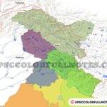
This article will take you through the important mountain ranges of Purvanchal Hills along with a beautiful purvanchal hills map. The map shows the location of important purvanchal hills which are Garo Khasi Jaintia, Dafla, Abor, Mishmi, Patkai bum, Mikir hills, Barail hill, Naga hills, Lushai hills, Mizo hills or Lushai hills. We will see these Purvanchal Hills state wise manner. You can also download the Purvanchal Hills Map in HD format from our Telegram Channel.
Major ranges within the Purvanchal Hills
Here is a list of some of the major ranges within the Purvanchal Hills:
- Dafla Hills
- Patkai Hills
- Mishmi Hills
- Abor Hills
- Naga Hills
- Lushai Hills
- Barail Range
- Garo Hills
- Khasi Hills
- Jaintia Hills
Hydro Power Potential of North-East India
The northeastern region of India is known to have a vast potential for untapped hydropower. The region is blessed with several major rivers such as the Brahmaputra, the Barak, the Dibang, the Lohit, and the Subansiri, which have the potential to generate a significant amount of electricity.
According to estimates, the region has a potential hydropower generation capacity of around 60,000 MW, out of which only a small portion has been harnessed so far. The untapped potential is mainly due to the lack of infrastructure, funding, and technical know-how to develop these projects.
The government of India has been working on several hydropower projects in the region, such as the 2080 MW Dibang Multipurpose Project, the 2000 MW Lower Subansiri Hydroelectric Project and the 2000 MW Kameng Hydroelectric Project.
The development of hydropower projects in the region could bring significant economic benefits, including job creation, increased income for local communities, and improved access to electricity. It could also help to reduce the country’s dependence on fossil fuels, and promote sustainable development.
Purvanchal Hills
Garo Khasi Jaintia
Lets see about Garo Khasi Jaintia Hills of Meghalaya
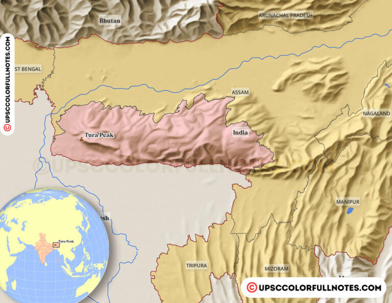
- Meghalaya, a small hilly state in North East India, came into existence as an autonomous state within the state of Assam on 2 April 1970 comprising the United Khasi and Jaintia Hills and the Garo Hills districts.
- But this experiment of creating an autonomous state within the mother state did not work for long due to the lack of cooperation between the two Governments.
- Consequently, the Government of India accorded full-fledged statehood to Meghalaya on 21 January 1972 to satisfy the persistent demand of the people.
- The boundaries of the state are demarcated by the Goalpara and Kamrup districts of Assam in the north, the south-western part of the district of Goalpara and a part of Rangpur district of Bangladesh in the west, the Mymensingh and Sylhet districts of Bangladesh in the south and the north Cachar and Karbi Anglong districts of Assam in the east.
- The total geographical area of the State is approximately 22,429 sq. km and consists of primarily steep hills and deep gorges with very limited areas covering valleys and plains land.
Broadly, the state is divided into three regions in terms of its physical features:
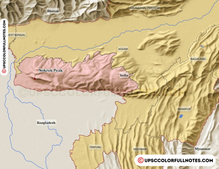
- The Central Plateau includes the Khasi – Jaintia Hills, which is an imposing, plateau with rolling grasslands, hills and river valleys. The Garo Hills forms the western part of the plateau. Its elevation varies between 150 M to 1961 M above the mean sea level. The highest point of the plateau and that of the entire state is the Shillong Peak whose elevation is about 196I M. It serves as a catchment area for rivers and streams traversing the state. Comparatively, it has the largest area of grassland, which can be profitably utilised for animal husbandry, dairying and horticulture. It is the main centre of potato cultivation and vegetables for supply outside the state.
- The border area begins where the southern face of the Central Plateau ends. Deep gorges and slopes at the foot of which a narrow strip of plain land runs along the international border with Bangladesh form the southern region of the state. It is a region with the heaviest rainfall. The world-renowned Cherrapunji and Mawsynram, the wettest places in the world are located in this area. The areca nut plantations and subtropical and tropical fruits like mandarin, lemon, guava, pineapple and banana are grown in plenty in this region.
- Like the border area, the submontane region also forms a continuation of the Central Plateau till it merges with the plains of Assam. But unlike the border area, which is generally steep and abrupt in certain places, it slopes gently down until it merges with the plains of Assam in the north. It is a region of comparatively lower rainfall but has favourable scope both for agriculture and horticulture.
- To summarise:
- Garo Hills: Nokrek Peak is the highest peak here.
- Khasi Hills: got its name Khasi tribes, Shillong is the highest peak.
- Jaintia Hills: located to the east of the Khasi Hills.

Dafla, Abor, Mishmi, Patkai bum
Lets see about Dafla, Abor, Mishmi, Patkai bum hill ranges of Arunachal Pradesh
The Dafla, Abor, Mishmi, and Patkai Bum hill ranges are located in the northeastern state of Arunachal Pradesh, India. These ranges are known for their rugged terrain and beautiful landscapes. The Dafla Hills are located in the western part of the state and are home to the Dafla tribe. The Abor Hills are located in the southern part of the state and are home to the Abor tribe. The Mishmi Hills are located in the eastern part of the state and are home to the Mishmi tribe.
The Patkai Bum hill ranges are located in the northern part of the state and are home to the Chakma and other ethnic groups. These ranges are also known for their rich biodiversity, with a wide variety of flora and fauna, including several endangered species. The ranges are also home to several historical and religious sites, including temples and monasteries that hold significant cultural and religious importance to the local tribes.
- Arunachal Pradesh is the most eastern state of India.
- Formerly the North-East Frontier Agency special territory, AP became a UT in 1972 and a state in 1987.
- It lies between 91° 32′ E to 97° 26′ E longitude and 26° 37′ to 29° 28′ N latitude.
- Total geographical area is 81,424 sq km.
- Arunachal Pradesh borders Assam to the south and Nagaland in the southeast. Burma/Myanmar lies towards the east, Bhutan towards the west, and the state is bordered on the north by the Tibet region of China.
- Itanagar is the capital of the state.
- A remote region, it includes part of the Eastern Himalayas and extends through mountainous highlands to the plains of Assam.
- Arunachal Pradesh is inhabited by people of Mongolic tribes, most of whom practice animism.
- In Sanskrit Arunachal Pradesh means “land of the dawn-lit mountains”
- It is also known as the “land of the rising sun” because of its position as the easternmost state of India.
- Arunachal Pradesh is entirely on the Eurasian tectonic Plate and much of Arunachal Pradesh is covered by the Himalayas.
- However, the parts of Lohit, Changlang and Tirap are covered by the ranges of Patkai hills.
- Kangto, Nyegi Kangsang, Main Gorichen peak, Eastern Gorichen peak are among the highest peaks in this area of the Himalayas.
- The Himalayan ranges of Arunachal Pradesh separate it from China.
- These ranges extend toward Nagaland, and then forms a boundary between India and Burma in Changlang and Tirap district, acting as a natural barrier called Patkai Bum Hills. These are low mountains when compared to the Greater Himalayas.
- To summarise:
- Daffla Hills: situated north of the Tezpur and is bounded on the east by the Abor Range.
- Abor Hills: In the far northeast of India, near the border with China. It is Drained by the Dibang River, a tributary of the Brahmaputra.
- Mishmi Hills: southward extension of the Great Himalayas and it touches China.
- Patkai Bum Hills: On the border with Burma. The word “Patkai” means “to cut chicken” in the Tai-Ahom language. conical peaks, steep slopes and deep valleys.

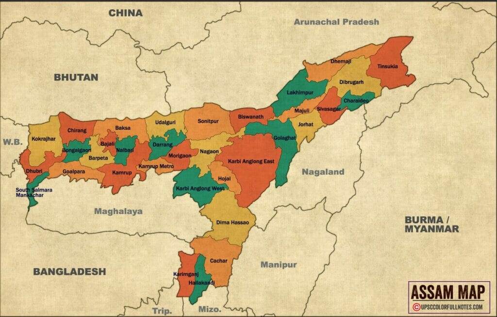
Now Lets see about Mikir hills and Barail hill ranges of Assam
Mikir hills
The Mikir Hills are a range of hills located in the northeastern Indian state of Assam, and also a small part of Nagaland state. The hills are known for their rugged terrain and beautiful landscapes, as well as the rich biodiversity of the region. The Mikir Hills are home to several ethnic groups, including the Mikir, Karbi, and Bodo tribes. These tribes have a rich cultural heritage and traditional practices that are closely tied to the natural environment of the hills.
The Mikir Hills are also known for their rich natural resources, including timber and minerals. The hills are also home to several wildlife sanctuaries and national parks, such as the Laokhowa Wildlife Sanctuary, which are important for conservation of the biodiversity of the region.
- Mikir hills of Assam are an extension of Shillong Plateau, covered by tropical rain forest which makes it highly inaccessible.
- Mikir Hills are located to the south of the Kaziranga National Park, Assam.
- Mikir Hills is the oldest landform in Assam.
- This landform is pear-shaped and encompasses an area of 7000 sq. km. Approx.
- It is part of the Karbi-Plateau.
- Highest peak – Dambuchko.
Barail Hill Range
The Barail Hill Range is a range of hills located in the northeastern Indian state of Assam. The Barail Hill Range is situated on the border of Assam and Nagaland. The range is known for its rugged terrain, beautiful landscapes, and rich biodiversity. The Barail Hill Range is home to several ethnic groups, including the Kachari, Dimasa, and Karbi tribes, who have a rich cultural heritage and traditional practices that are closely tied to the natural environment of the hills.
The range is also known for its rich natural resources, including timber and minerals. The Barail Hill Range is also home to several wildlife sanctuaries and national parks, such as the Dihing-Patkai Wildlife Sanctuary and the Dibru-Saikhowa National Park, which are important for the conservation of the biodiversity of the region. The Barail Hill Range is also a popular destination for trekking and adventure sports.
- Barail Hill Range lies in North Cachar Hill District, and is the south-western extension of the Patkai Range.
- It runs in a south-westerly direction from southern Nagaland and parts of northern Manipur, up to the Jaintia Hill of Meghalaya.
- The higher elevation (1,500-2,500 m) areas of the Range is located in southern Nagaland state, while low to mid-elevation areas are in the North Cachar and Cachar Districts, continuing up to the Jaintia Hills of Meghalaya.
- Barail Wildlife Sanctuary is situated here and spreads over an area of 326 sq km.
- This sanctuary mainly covers the low to mid-elevation hills (< 30-1,100 m) of Cachar District of southern Assam. These low hill ranges are continuous with the more lofty mountainous parts of North Cachar Reserve Forest and continuous with Barail Hill Ranges in the North Cachar Hills District.
- The sanctuary area is drained by a network of small perennial or seasonal streams that flow through small ravines and valleys, and join Jatinga River at the western boundary of the Sanctuary.
- The River Dolu runs through the eastern boundary of the Sanctuary.
- The Silchar-Half-long railway track and the Silchar-Halflong road pass along the western boundary of BWS.
- The primary vegetation is tropical semi-evergreen to moist evergreen forest.


Now lets see the remaining important purvanchal hills with map
NAGA Hills
- Nāga Hills, part of the complex mountain barrier on the border of India and Myanmar (Burma).
- A northern extension of the Arakan Yoma system, the Nāga Hills reach a height of 12,552 feet (3,826 m) in Mount Saramati on the India-Myanmar frontier.
- The part of the range within India constituted the Nāga Hills district of Assam until 1961 and since 1963 has been part of Nāgāland.
- The hills receive a heavy monsoon rainfall and are naturally clothed with dense forest.
- Placed throughout the hills are villages of the Nāga tribes.
- In their natural state, these hills are covered with dense, evergreen forest.
- Most of the easier slopes up to a height of about 5,000 feet have at one time or another been cleared for cultivation. Where this has been done, they are covered for the most part by scrub bamboo and grass and the larger forest trees have disappeared.
- The Angamis tribe inhabited this place, and the hillsides have been cut by them into terraced rice fields and there is comparatively little jungle to be seen.
- Nowhere, is there large timber remaining except on the bottom of the river valleys and the summits of the hills.
- In the neighbourhood of Kohima, the valleys are broad, the slopes of the hills are fairly easy and have, to a great extent, been brought under cultivation and the scenery is, for a hill district, unusually tame.
- The lower hills are not so healthy and are in consequence but sparsely peopled.
Mizo Hills
The Mizo Hills, also known as the Lushai Hills, are a range of hills located in the northeastern Indian state of Mizoram and also share some parts with Assam and Tripura. The range is known for its rugged terrain, beautiful landscapes, and rich biodiversity. The Mizo Hills are home to the Mizo people, also known as Lushai people, who have a rich cultural heritage and traditional practices that are closely tied to the natural environment of the hills.
The range is also known for its rich natural resources, including timber and minerals. The Mizo Hills are also home to several wildlife sanctuaries and national parks, such as the Phawngpui Blue Mountain National Park, which are important for conservation of the biodiversity of the region. The Mizo Hills are also popular for trekking and adventure sports. The name Mizo Hills was adopted in the late 1950’s, as the Mizo National Front (MNF) started a movement for an independent Mizo state which was later merged to form the state of Mizoram in 1986.
- Mizo Hills, formerly Lushai Hills, is a mountain range in southeastern Mizoram state.
- These ranges are part of the North Arakan Yoma system.
- The Mizo Hills rise to about up to 2,125 metres, and their slopes are covered with thick evergreen forest
- Bamboo is a dominant species here.
- In the intermontane valleys, shifting (slash-and-burn) agriculture and some terrace cultivation are practised.

Other North East Hills
Some lesser Known ranges in North-East are as Follow
- Kachin Hills
- Lohit Range
- Namdapha Hills
- Tawang Hills
- Tirap Hills
- Subansiri Hills
- Dibang Hills
- Kamlang Hills
- Siang Hills
- Subansiri Hills
- Dibang Hills
- Kamlang Hills
- Siang Hills
Kachin Hills
The Kachin Hills are a range of hills located in the northeastern part of India and also extending to the neighbouring country Myanmar. The hills are situated in the state of Arunachal Pradesh and Nagaland in India, and Kachin state in Myanmar. The range is known for its rugged terrain, beautiful landscapes, and rich biodiversity. The Kachin Hills are home to the Kachin people, who have a rich cultural heritage and traditional practices that are closely tied to the natural environment of the hills.

The range is also known for its rich natural resources, including timber, minerals and hydropower. The Kachin Hills are also home to several wildlife sanctuaries and national parks, such as the Dibang Wildlife Sanctuary and the Kamlang Wildlife Sanctuary, which are important for conservation of the biodiversity of the region. The Kachin Hills are also popular for trekking and adventure sports, and also known for the traditional practices of the Kachin people, such as jhum cultivation and hunting.
Lohit Range
The Lohit Range is a mountain range located in the northeastern Indian state of Arunachal Pradesh. It is part of the Eastern Himalayans and is situated in the easternmost part of the state, bordering with China and Myanmar. The range is known for its rugged terrain, beautiful landscapes, and rich biodiversity. The Lohit Range is home to several ethnic groups, including the Mishmi, Adi, and Digaru-Mishmi tribes, who have a rich cultural heritage and traditional practices that are closely tied to the natural environment of the hills.

The range is also known for its rich natural resources, including timber and minerals. The Lohit Range is also home to several wildlife sanctuaries and national parks, such as the Namdapha National Park and the Kamlang Wildlife Sanctuary, which are important for conservation of the biodiversity of the region. The Lohit Range is also a popular destination for trekking and adventure sports, as well as a source of major rivers like Lohit, Dibang and Brahmaputra.
Namdapha Hills
The Namdapha Hills are a range of hills located in the northeastern Indian state of Arunachal Pradesh. The range is situated in the easternmost part of the state and is known for its rugged terrain, beautiful landscapes, and rich biodiversity. The Namdapha Hills are home to several ethnic groups, including the Mishmi, Adi, and Digaru-Mishmi tribes, who have a rich cultural heritage and traditional practices that are closely tied to the natural environment of the hills. The range is also known for its rich natural resources, including timber and minerals.
The Namdapha Hills are also home to the Namdapha National Park, which is one of the largest protected areas in the Eastern Himalayas, and it is known for its unique and diverse flora and fauna, including several endangered species. The park is also home to four major big cat species: Bengal tiger, clouded leopard, snow leopard, and the marbled cat. The Namdapha Hills are also popular destination for trekking and adventure sports, as well as for nature enthusiasts and researchers.
Tawang Hills
The Tawang Hills are a range of hills located in the northeastern Indian state of Arunachal Pradesh. The range is situated in the westernmost part of the state, and is known for its rugged terrain, beautiful landscapes, and rich biodiversity. The Tawang Hills are home to the Tawang Monpa people, who have a rich cultural heritage and traditional practices that are closely tied to the natural environment of the hills.
The range is also known for its rich natural resources, including timber and minerals. The Tawang Hills are also home to the Tawang Monastery, which is the largest Buddhist monastery in India and second largest in the world after the Potala Palace in Lhasa, Tibet. The Monastery is a sacred site for Tibetan Buddhism and is visited by many tourists and religious pilgrims.
Tirap Hills
The Tirap Hills are a range of hills located in the northeastern Indian state of Arunachal Pradesh. The range is situated in the southern part of the state and is known for its rugged terrain, beautiful landscapes, and rich biodiversity. The Tirap Hills are home to several ethnic groups, including the Nocte, Wancho, and Tangsa tribes, who have a rich cultural heritage and traditional practices that are closely tied to the natural environment of the hills.
The range is also known for its rich natural resources, including timber and minerals. The Tirap Hills are also home to several wildlife sanctuaries and national parks, such as the Pakke Tiger Reserve and the Sessa Orchid Sanctuary, which are important for conservation of the biodiversity of the region.
Subansiri Hills
The Subansiri Hills are a range of hills located in the northeastern Indian state of Arunachal Pradesh. The range is situated in the western part of the state and is known for its rugged terrain, beautiful landscapes, and rich biodiversity. The Subansiri Hills are home to several ethnic groups, including the Apatani, Nyishi, and Tagin tribes, who have a rich cultural heritage and traditional practices that are closely tied to the natural environment of the hills.
The range is also known for its rich natural resources, including timber and minerals. The Subansiri Hills are also home to several wildlife sanctuaries and national parks, such as the Kamlang Wildlife Sanctuary and the Mehao Wildlife Sanctuary, which are important for conservation of the biodiversity of the region.
Dibang Hills
The Dibang Hills are a range of hills located in the northeastern Indian state of Arunachal Pradesh. The range is situated in the eastern part of the state and is known for its rugged terrain, beautiful landscapes, and rich biodiversity. The Dibang Hills are home to several ethnic groups, including the Idu, Digaru-Mishmi, and Miji tribes, who have a rich cultural heritage and traditional practices that are closely tied to the natural environment of the hills.
The Dibang Hills are also home to several wildlife sanctuaries and national parks, such as the Dibang Wildlife Sanctuary and the Mehao Wildlife Sanctuary, which are important for conservation of the biodiversity of the region.
Kamlang Hills
The Kamlang Hills are a range of hills located in the northeastern Indian state of Arunachal Pradesh. The range is situated in the eastern part of the state and is known for its rugged terrain, beautiful landscapes, and rich biodiversity. The Kamlang Hills are home to several ethnic groups, including the Adi, Idu, and Digaru-Mishmi tribes, who have a rich cultural heritage and traditional practices that are closely tied to the natural environment of the hills.
The Kamlang Hills are also home to the Kamlang Wildlife Sanctuary, which is a protected area that is known for its diverse flora and fauna, including several endangered species. The Sanctuary is also home to the Hoolock Gibbon, which is the only ape found in India.
Siang Hills
The Siang Hills are a range of hills located in the northeastern Indian state of Arunachal Pradesh. The Siang Hills are home to several ethnic groups, including the Adi, Galo, and Apatani tribes, who have a rich cultural heritage and traditional practices that are closely tied to the natural environment of the hills. The Siang Hills are also the source of the Siang River, which later joins with the Lohit and Dibang rivers to form the Brahmaputra River.
Subansiri Hills
The Subansiri Hills are a range of hills located in the northeastern Indian state of Arunachal Pradesh. The Subansiri Hills are home to several ethnic groups, including the Apatani, Nyishi, and Tagin tribes, who have a rich cultural heritage and traditional practices that are closely tied to the natural environment of the hills. The range is also known for its rich natural resources, including timber, minerals and hydropower. The Subansiri Hills are also home to several wildlife sanctuaries and national parks, such as Rupa-Kangto Wildlife Sanctuary which are important for conservation of the biodiversity of the region. The Subansiri River, which is a major tributary of the Brahmaputra, originates from the glacier of the Subansiri Hills.
Kamlang Hills
The Kamlang Hills are a range of hills located in the northeastern Indian state of Arunachal Pradesh. The Kamlang Hills are home to several ethnic groups, including the Adi, Idu, and Digaru-Mishmi tribes. The Sanctuary is also home to the Hoolock Gibbon, which is the only ape found in India. The Kamlang Hills is also known for the traditional practices of the Adi people, such as the Solung festival, which is celebrated in September every year.
Siang Hills
The Siang Hills are a range of hills located in the northeastern Indian state of Arunachal Pradesh. The Siang Hills are also the source of the Siang River, which later joins with the Lohit and Dibang rivers to form the Brahmaputra River, which is one of the major rivers in the region.
This was all about the important purvanchal hills which are Garo Khasi Jaintia, Dafla, Abor, Mishmi, Patkai bum, Mikir hills, Barail hill, Naga hills, Lushai hills, Mizo hills or Lushai hills.
If you want to learn more about Purvanchal hills refer to the Britannica


overwhelmeddd……. Ma’m/Sir
Humble and Greatful….
Hey Thanks a Lot for such Nice words.