Latest Topics in News


Ken River
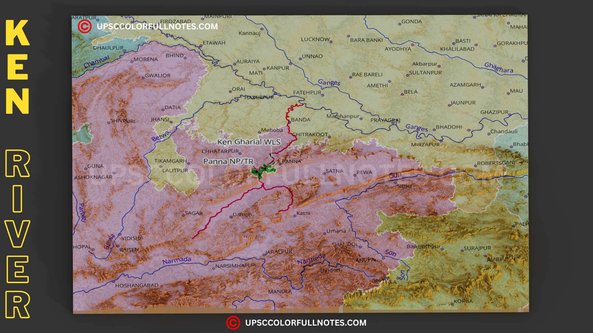
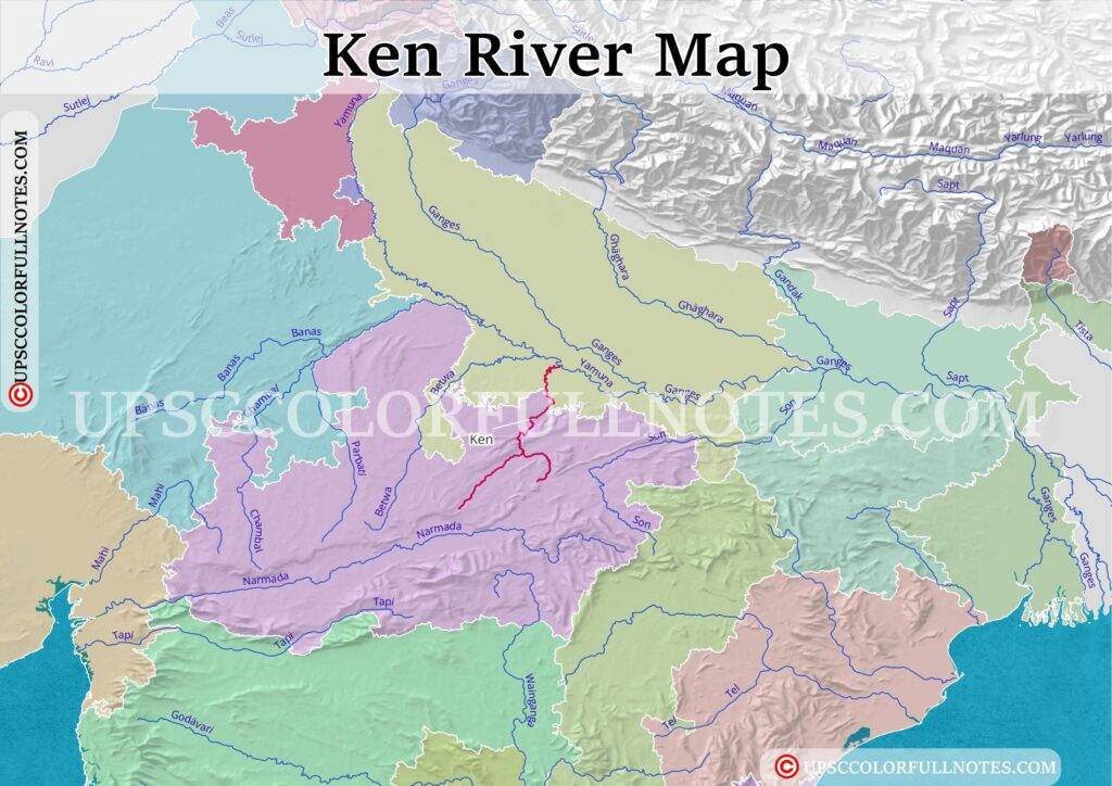
The Ken River is one of the major rivers of the Bundelkhand region of central India. It originates near the village of Ahirgawan on the north-west slopes of the Kaimur Range in the Katni district of Madhya Pradesh, at an elevation of about 550 meters (1,804 feet) above mean sea level.
The Ken River flows through the states of Madhya Pradesh and Uttar Pradesh, traversing a total distance of 427 km (265 mi). Out of its total length, 292 km (181 mi) lies in Madhya Pradesh, 84 km (52 mi) in Uttar Pradesh, and 51 km (32 mi) forms the boundary between the two states. It finally merges with the Yamuna River near Chilla village in the Banda district of Uttar Pradesh at the coordinates 25°46′N 80°31′E. The river is a significant water source for the drought-prone Bundelkhand region and serves as a lifeline for the people living in the area.
What is the geography of the Ken River?
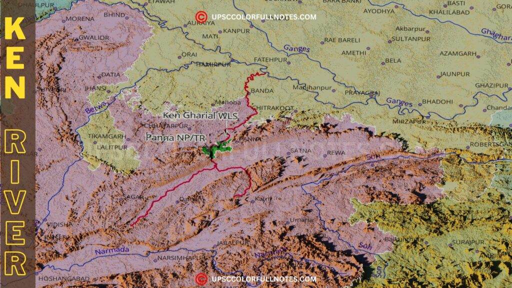
The Ken River basin is characterized by unique topographical features and climatic conditions. The basin lies between the latitudes of 23°12′ N and 25°54′ N and the longitudes of 78°30′ E and 80°36′ E. The river flows through the Bijawar-Panna hills, cutting a deep gorge that is 60 km (37 mi) long and 150-180 m (492-590 ft) deep. The Raneh Falls, located on the Ken River, is a popular tourist attraction known for its stunning geological formations made of granite, dolomite, and quartz rocks.
What are the major tributaries of the Ken River?
The Ken River has several important tributaries that contribute to its flow. The Sonar River, with a drainage area of 12,620 km2 (4,873 sq mi), is the largest tributary of the Ken and lies entirely within Madhya Pradesh. Other significant tributaries include the Bawas, Dewar, Kaith, and Baink on the left bank, and the Kopra and Bearma on the right bank.
Major tributaries of the Ken River, categorized by left bank and right bank:
| Left Bank Tributaries | Right Bank Tributaries |
|---|---|
| Bawas River | Sonar River (largest tributary, entirely within Madhya Pradesh) |
| Dewar River | Kopra River |
| Kaith River | Bearma River |
| Baink River | Urmil River |
| Shyamari River | Mirhasan River |
| Kutni River | |
| Banne River | |
| Patne River |
What protected areas are near the Ken River?
The Ken River flows through the Panna National Park, which is known for its rich biodiversity and is home to the famous Panna Tiger Reserve. The Ken Gharial Sanctuary, located along the river, was established in 1981 to protect the critically endangered gharial population. The Panna Biosphere Reserve, designated by UNESCO, plays a crucial role in conserving the unique ecosystem of the region.
Protected Areas Near the Ken River:
| Protected Area | Description |
|---|---|
| Panna National Park | Known for its rich biodiversity and is home to the Panna Tiger Reserve. The Ken River flows through the park. |
| Ken Gharial Sanctuary | Established in 1981 along the Ken River to protect the critically endangered gharial population and other aquatic species like the mugger crocodile and freshwater turtles. |
| Panna Biosphere Reserve | Designated by UNESCO, plays a crucial role in conserving the unique ecosystem of the region around the Ken River. |
| Raneh Falls | Popular tourist attraction on the Ken River known for its stunning geological formations made of granite, dolomite, and quartz rocks. |
How is the Ken River linked to the Yamuna and Ganga river systems?
The Ken River is a tributary of the Yamuna River, which it joins near the village of Chilla in the Banda district of Uttar Pradesh. The Yamuna, in turn, is a major tributary of the Ganga River, and the confluence of the two rivers Triveni Sangam, is considered a sacred site in Hinduism.
Why is the Ken River ecologically important?
The Ken River basin as you can see in our detailed maps supports a rich and diverse array of flora and fauna in Bundelkhand region of central India. The establishment of the Ken Gharial Sanctuary has been instrumental in protecting the critically endangered gharial population, as well as other aquatic species such as the mugger crocodile and various freshwater turtles. The Panna NP/TR is also supported by Ken river, as it directly crosses it as can be seen in above maps.
How does the Ken River impact agriculture and human settlements?
The Ken River plays a vital role in supporting agriculture in the region, providing water for irrigation and sustaining the livelihoods of local communities in to the water-deficit Bundelkhand region of central India. Several cities and historical sites, such as Banda and the ancient castles of the Rajputs, are located along the banks of the Ken River.
What is the Ken-Betwa River Link Project and its objectives?
The Ken-Betwa River Link Project is an ambitious interlinking project that aims to transfer surplus water from the Ken River to the water-stressed Betwa River basin. The project’s main objectives are to provide irrigation facilities to the drought-prone Bundelkhand region, generate hydropower, and supply drinking water to the local population. The project is expected to provide annual irrigation of 10.62 lakh hectares, according to the Jal Shakti Ministry.
But, the project has faced several challenges and environmental concerns, such as the submergence of a significant portion of the Panna Tiger Reserve and the potential impact on the rich ecosystem of central India.
How do human activities impact the Ken River?
The Ken River faces various challenges due to human activities such as agriculture, urbanization, and industrialization. The increasing demand for water in this heavily populated central indian landscape, coupled with the discharge of untreated waste and effluents from human population living here, has also led to the deterioration of the river’s water quality. Balancing economic development with the conservation of the river’s ecosystem is a critical issue that needs to be addressed.
What are the conservation efforts for the Ken River and its wildlife?
Several initiatives have been undertaken to protect the Ken River’s ecosystem and its associated wildlife. The establishment of protected areas such as the Panna National Park and the Ken Gharial Sanctuary has been crucial in conserving the biodiversity of the region.
Some recent important GOI intiatives for Ken river are:
- Comprehensive Landscape Management Plan: Prepared by the Wildlife Institute of India, this plan is designed to manage and safeguard the environment, including the wildlife around the Panna Tiger Reserve and the surrounding areas affected by the Ken-Betwa Link Project (KBLP).
- Greater Panna Landscape Council (GPLC): The process of constituting the GPLC is underway to implement the landscape management plan for the conservation of the region’s wildlife.
- Project Management Consultant (PMC): A PMC is proposed to be hired to assist the Ken Betwa Link Project Authority in the implementation of the project, which includes environmental and wildlife conservation measures.
Final Thoughts
In conclusion, the Ken River is a vital water source for the Bundelkhand region of central India, flowing through the states of Madhya Pradesh and Uttar Pradesh.
The river’s unique geography, characterized by deep gorges and stunning geological formations, significantly supports a rich biodiversity, and several protected areas, such as the Panna National Park and the Ken Gharial Sanctuary.
The river also plays a crucial role in sustaining agriculture and human settlements in the region. However, the Ken River faces various challenges due to human activities, including pollution and the increasing demand for water and the proposed Ken-Betwa River Link Project.