Latest Topics in News


The Umngot River of Meghalaya
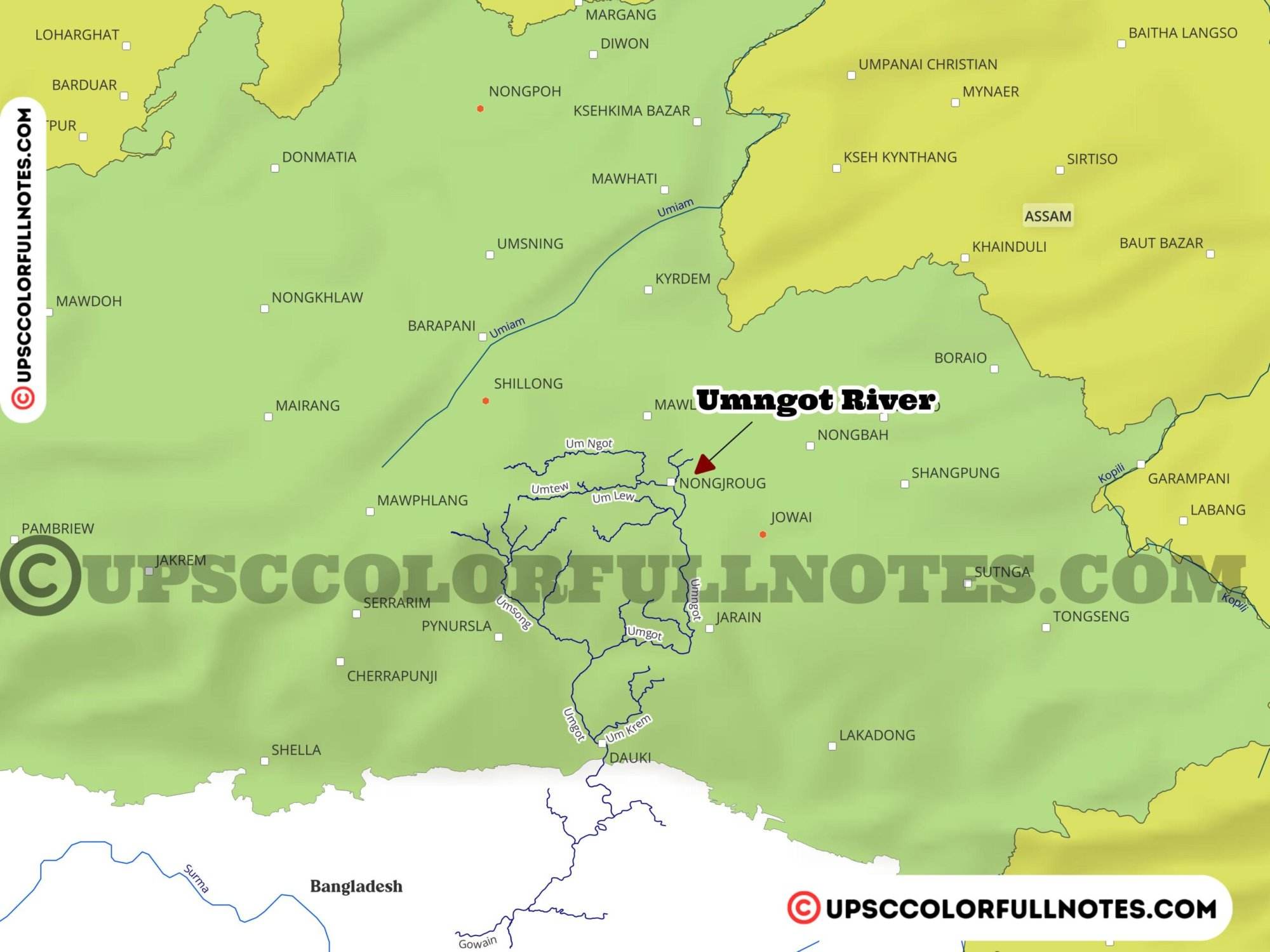
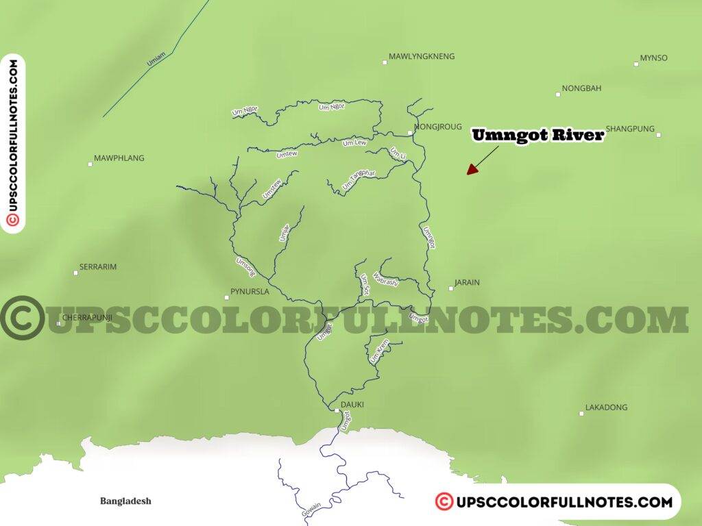
The Umngot River, also known as the Dawki River, is located in the state of Meghalaya in northeast India. It originates from the eastern part of the Shillong Peak near Smit village in East Khasi Hills district at an altitude of about 1800 meters above sea level. The 82 km long Umngot River then goes on to form the boundary between the East Khasi Hills and Jaintia Hills districts before entering the plains of Bangladesh.
In this article, the UCN Team provides a detailed analysis, presenting key concepts and insights on the Umngot river alongwith Umngot River Maps.
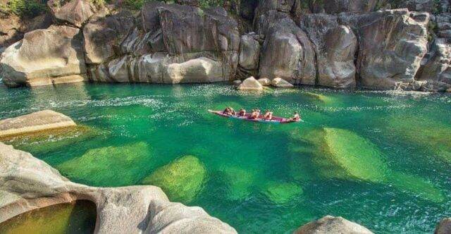
The Umngot River is described as the “lifeline” for the people living along its banks. It is a major fishing spot that supports the “livelihood and nutritional security” for local communities through its “richest riverine fisheries“. Its waters are crystal clear allowing visibility of the river bed even from a distance. The river is surrounded by verdant hills and dense forests that form a “rich natural habitat.
In short, the Umngot River is a significant waterway in Meghalaya that acts as an important resource for fishing, irrigation, livelihoods and transportation for districts like East Khasi Hills and Jaintia Hills. It also represents an invaluable natural ecosystem for the state.
Geographical Details
Origin and Endpoint
The Umngot River starts its journey from the eastern part of the Shillong Peak near Smit village located in the East Khasi Hills district of Meghalaya. The river then flows for a distance of 82 kilometers before entering the plains of Bangladesh.
Boundary Between Districts
The Umngot River forms the natural boundary between two districts in Meghalaya. It separates the East Khasi Hills district from the Jaintia Hills district as it flows from its origin near Shillong towards Bangladesh.
States and Districts
The Umngot River passes only through one state – the state of Meghalaya in northeast India. Within Meghalaya, it flows through two districts – East Khasi Hills where it originates and Jaintia Hills which it separates from the former.
Key Details and Features
Depth/Width Details
The width of the Umngot River varies greatly across its span. The average width is around 75 meters but it ranges from as narrow as 85 meters to as wide as over 285 meters. However, the river is marked by very shallow depth in parts. As per govt. surveys, the depth is “insufficient for navigation” in stretches of the Umngot with some segments only 0.5 meters deep.
Bridges and Crossings
There are two prominent bridges across the river. One is the Dawki suspension bridge located near Dawki village. The other one is “steel bridge” near the Shnongpdeng.
Environment
The Umngot River passes through a rich natural environment. Its waters are crystal clear and “blue-green” in appearance allowing visibility of the river bed from a great distance. This supports a thriving “riverine fishery” which is one of the “richest in India”. The hills and dense forests surrounding the river also provide a “rich natural habitat”.
So key details of the Umngot River include great variation in width between 85-285 meters, shallow depth and two bridges across – the steel bridge and Dawki suspension bridge. The river itself has lush green surroundings and pristine clear waters.
Usage and Activity
Fishing and Angling
Fishing is a major activity taking place along the Umngot River. The Umngot is described as supporting “richest riverine fisheries in India” and a “prime fishing spot” for fishermen from nearby villages. Apart from local consumption, fishing provides livelihood opportunities for communities living along the banks of this river.
Sand and Gravel Mining
There are indications of gravel mining observed along the Umngot River as per govt. surveys, and it categorizes much of this mining by locals as “illegal”.
Ferry Crossing and Transport to Bangladesh
A prominent usage is the Dawki ferry crossing and associated Dawki ferry ghat. This allows river trade and transport of cargo between India and Bangladesh via the Umngot River. Commodities transported include coal, vegetables, fish etc.
Development and Issues
Encroachment on Banks
Government Surveys of the Umngot River indicate encroachment issues along its banks. Human habitation and agricultural lands are right up to the river banks at certain locations making them prone to threats of erosion.
Flood Threats
The major threat is that of seasonal floods. Heavy rainfall and loose rocky river banks lead to floods that damage standing crops and require costly repairs of infrastructure.
Need for Bank Protection
Due to flood threats, the river bank reinforcement and protection works like Stone pitching, embankments and boulder pitching have been undertaken along the river at some areas.
Final Thoughts
In the UCN team’s thoughtful analysis the Umngot River can be described as the “lifeline” for local communities in Meghalaya, underscored by its sustained usage for fishing, transport, irrigation etc. However, rising activity and development pressures are beginning to threaten it – whether from encroachment issues or seasonal floods. On the other hand, Umngot flows amidst a “rich natural habitat” framed by verdant forests and crystal blue waters. But mining and erosion eat into this fragile ecosystem.
Going forward, a balanced strategy is the need of the hour – one that allows measured development of the Umngot River for locals who depend on it but combines this with conservation to preserve its critical natural ecosystems. Specific measures could encompass crackdowns on illegal sand mining, fortified embankments, restricted construction encroaching on the river and sustained reforestation initiatives along its banks. The geographical location also means potential for trade with Bangladesh can be tapped via transport routes on the Umngot River.