Latest Topics in News

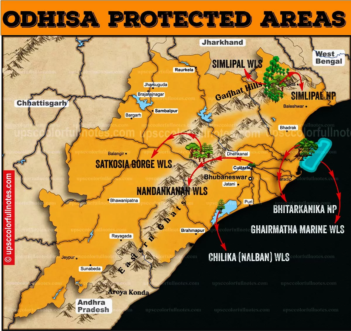


Odhisa is endowed with Chilika Lake, Bhitarkanika National Park, Satkosia Tiger Reserve, Simipal Biosphere Reserve, Gahirmatha Marine Sanctuary, Irrawaddy Dolphins, and many other protected areas. This article will dive into the above mentioned protected areas of Odisha.
Chilika Lake
- The Chilika Lake was part of the Bay of Bengal during the latter stages of the Pleistocene period, as the geological evidence available indicates.
- The reasons attributed to the growth of the spit and changes in the morphology of the coast along the north of the lake are:
- strong winds, shifting sand to the shore,
- Longshore drift (littoral drift)
- The presence or absence of strong river and tidal currents in different areas.
- Rajhansa, the 60-km (37 miles)-long barrier beach formed by northerly currents in the Bay of Bengal, resulted in the formation of this shallow Chilika lake and formed its eastern side.
- Chilika Lake is a shallow brackish-water inshore lake linked with the Bay of Bengal through a narrow mouth.
- Chilika Lake is sandwiched between the Bay of Bengal and the mountains.
- The creation of a barrier spit near Palur due to littoral drift and the creation of a sand bar along the eastern shore of the lake has transformed Chilika Lake gradually into a shallow lagoon.
- The Bay of Bengal is connected with the Chilika lake near Satapada through a number of shoals, sand bars, sand spits, openings of shallow depth, and a narrow channel. The presence of these features has considerably reduced the tidal flow in and out of the lake.
- In the past, the discharge of sediment by the tributaries of the Mahanadi River made the lake shallower, and subsequently, the lake was separated from the sea after the formation of the spit.
- The Chilika lake is gradually becoming shallow; various new land features such as sandbanks and a number of islands are now visible in the lake because of the discharge of silt and sediment by the rivers Daya, Bhargavi, Makra, and Nuna.
- About 1.6 million metric tons per year of sediment is deposited in Chilika Lake by rivers and several streams. Some of the rivers are tributaries of the Mahanadi River, and others are streams joining the lake.
- The water level in Chilika lake shows seasonal fluctuations and also during high and low tides. Similarly, A large area of Chilika Lake experiences submergence and emergence every year.
Geography and topography of Chilika Lake
- Chilika, the largest subelliptical brackish-water lagoon in Asia and one of the largest tropical lagoons in the world, has been marked as Category I of the marine protected areas and designated as a Ramsar site by the Ramsar Convention of Wetlands in 1981.
- The western and southern margins of the lake are fringed by the Eastern Ghats hill range.
- The north shore of the Chilika lake is part of the Khordha district, and the western shore is part of the Ganjam district of Odhisa.
- The Chilika lake is a shallow water body with an average depth of 2 m and is about 65 km in length; It spreads from northeast to southwest parallel to the coastline with a variable breadth reaching up to 20.1 km.
- The lagoon spreads over an area of 950 sq. km during summer, which swells up to 1,165 Sq.km during monsoon. The lagoon is connected with the Bay of Bengal near Satapada by means of an artificial opening made in September 2000, before which a 24-km-long narrow and curved channel running parallel to the coast was joined with the Bay of Bengal near Arakhakuda.
- During winter, a large portion of this lagoon remains submerged and acts as a wetland, which also serves as breeding and nesting grounds for millions of migratory bird species.
- High evaporation during summer and a large inflow of fresh water during the monsoon and post-monsoon seasons significantly influence the water spread area of the lagoon.
- The catchment area of the Chilika lagoon is 4,406 Sq. Km, in which 68% is constituted by western catchment and 32% by the Mahanadi delta. The total inflow of freshwater has been estimated at 14,331 million cubic kilometres per year.
- The three distributaries of the Mahanadi River, namely Daya, Bhargavi, and Nuna, account for 55% of the total inflow, whereas the streams/rivulets from the western catchment contribute the rest 45%.
- Over the years, the lake environment has been under severe stress due to siltation, changes in salinity, weed infestation, aquaculture activities, the decline in fish yield, loss of biodiversity, etc.
- A severe cyclonic storm in 1999 caused a dramatic change in the biotic communities in the lake.
Irrawaddy dolphin in Chilika Lake
- Irrawaddy dolphins fall under
- Schedule I of the Indian Wildlife (Protection) Act, 1972
- IUCN Red List of Endangered Species.
- Irrawaddy dolphins are found in coastal areas in South and Southeast Asia and in three rivers: Irrawaddy (Myanmar),
- Mahakam (Indonesian Borneo)
- Mekong (China).
- Irrawaddy Dolphin distribution in lake Chilika is considered to be the highest single lagoon population.

Gahirmatha Marine Sanctuary
- The Indian coastline extends over 7,500 km and harbours a variety of specialised marine ecosystems like coral reefs, seagrass, mangroves, nesting and feeding grounds, and lagoons, supporting various resources.
- Bhitarkanika is one such unique ecosystem (mangroves, nesting and breeding grounds for turtles) situated on the east coast of India in the state of Orissa.
- The coastline of this region is sandy and free of rocks and stones. The area includes the internationally reputed Bhitarkanika Wildlife Sanctuary and Gahirmatha Marine Sanctuary.
- The Gahirmatha Marine Sanctuary, located in the Bhirtarkanika Wildlife Sanctuary, hosts the world’s most significant known nesting ground for olive ridley turtles. However, in the last 20 years, large scale mortality and shifting of nesting have been observed.
- The uniqueness of this area’s topography lies in how it is crisscrossed by a network of rivers and flanked by the sea on one side.
- The region is home to many spectacular plant and animal species. The vegetation consists of deltaic mangrove forests and deciduous and semi-deciduous forests.
Gahirmatha Marine Sanctuary
- The coast of Gahirmatha is a low-lying sandy area with commonly occurring tidal creeks and mudflats. Several sandy islands are found along this coast, and the presence of a barrier ridge (barrier island) is an important feature that protects the sandy island from erosion.
- The coast is a low lying area drained by the rivers Baitarani, Brahmani, Dhamra, Maipura, Bansgarh, and Ranhahansua.
- The massive arribada nesting sites of the olive ridley sea turtles along the Gahirmatha coast in Odhisa are unique and exciting features in the biological realm.
- To protect the olive ridley turtle’s breeding and nesting grounds in Gahirmatha, the government of Odhisa declared it a Marine Sanctuary.
- The notification for declaring the Marine Sanctuary was published in October 1997.
- Fishing on the Gahirmatha coast was restricted in 1993, and a complete fishing ban was imposed in this area in 1997 when Gahirmatha was given the status of a Marine Sanctuary.
- The core area of the Gahirmatha Marine Sanctuary is 725 sq. km, and fishing here is prohibited throughout the year.
- The Gahirmatha Marine Sanctuary has an average width of 11 km offshore of Ekakulanasi in the North-East and 10 km from Barunei Muhana to Mahanadi Muhana.
- The buffer zone of the Gahirmatha Marine Sanctuary stretches over an average width of 10 km, where fishing is restricted during the nesting season from December to April.
Marine turtles
- Marine turtles are found in tropical and temperate seas throughout the world.
- Adults of the species are found in shallow coastal waters, bays, lagoons, and estuaries. Some also venture into the open sea.
- There are eight species of sea turtles in the world. They are
- Chelonia mydas (green turtle);
- Chelonia agassizii (black turtle);
- Caretta caretta (loggerhead);
- Lepidochelys kempii (Kemp’s ridley);
- Lepidochelys olivacea (olive ridley);
- Eretmochelys imbricata (hawksbill);
- Natator depressus (flatback turtle);
- Dermochelys coriacea (leatherback).
Marine Turtle in India
- In Indian coastal waters, five species of sea turtle are known to occur, of which four species occur in the coastal waters of the Orissa and Gahirmatha coasts. The five species of Indian turtles are
- Olive ridley turtle – Lepidochelys olivacea,
- Hawksbill turtle – Eretmochelys imbricata,
- Leatherback turtle – Dermochelys coriacea,
- Black turtle – Chelonia mydas,
- Loggerhead Turtle – Caretta caretta.
- In order of abundance, they are Olive ridley turtle, Hawksbill turtle, Leatherback turtle, and Black turtle.
Operation Olivia to the rescue of Olive Ridleys
Every year, from November to December, the Indian Coast Guard’s “Operation Olivia” assists in protecting Olive Ridley turtles when they assemble along the Odisha coast for breeding and nesting. (Began in the early 1980s)
- • It is an annual initiative aimed at protecting Olive Ridley Sea turtles throughout their nesting seasons and conserving their natural breeding grounds.
- • The Mission was initiated this year, 2021, collaborating with the Odisha State Forest Department. This unique nature protection initiative has involved two specialised coast guard ships and several small planes.
- • The two ships will guarantee that fishing vessels do not reach important turtle breeding areas such as the Gahirmatha marine sanctuary, the Dhamara River, and Rushikulya beach.
- • As part of the objective, the Coast Guard maintains a close eye on illegal fishing and turtle catching in this area. They also connect with local fishermen and residents to increase awareness about the need to preserve Olive Ridleys.
Olive Ridley Turtles
- Olive Ridley turtles are a marine turtle species that have been designated as vulnerable by the International Union for Conservation of Nature (IUCN).
- It is listed on Schedule I of the Indian Wildlife Protection Act of 1972, as well as Appendix I of the Convention on International Trade in Endangered Species of Wild Fauna and Flora (CITES).
- The species is one of the most common sea turtles in the world.
- It is found predominantly in tropical and warm seas, primarily in the Pacific and Indian Oceans, but sometimes in the warm waters of the Atlantic Ocean.
- They are well-known for their distinctive mass nesting behaviour known as arribadas, in which females lay eggs in the moonlight.
Bhitarkanika National Park

- Bhitarkanika a spectacular National Park of India is endowed with the largest biodiversity of mangrove species.
- There are about 71 species of mangrove found in Bhitarkanika National Park.
- The Bhitarkanika National Park mangrove forest is the second largest mangrove in India.
- Mangroves of Brahmani and Baitarani delta of Kendrapara district have been declared as Bhitarakanika Wildlife sanctuary in April 1975 covering an area of 145 sq. km.
- Located on the seaside of the Bhitarakanika sanctuary /National park, an area of 1435 sq. km. has been declared as Gahirmatha Marine Wildlife Sanctuary in 1997.
- Bhitarakanika is endowed with a very complex sub ecosystem of freshwater, marine and terrestrial, which intricately mixed with each other.
- The local communities inhabiting these mangrove forests fulfil their day to day requirements such as food, fodder, timber, fuel, medicine etc by utilising these mangrove forests.
- Mangroves are the tidal forests of coastal wetland, existing in the intertidal zones of sheltered shores, estuaries, tidal creeks, backwaters, lagoons, marshes and mudflats of the tropical and sub-tropical regions of the world.
- Bhitarkanika National Park is located in the estuary of Brahmani, Baitarani, Dhamra & Mahanadi river systems.
- Bhitarkanika National Park is the habitat of Bhitarkanika National Park is home to the largest population of the endangered Saltwater crocodiles in India.
- leopard cat, fishing cat, jungle cat, hyena, wild boar, spotted deer,
- porcupine, dolphin, saltwater crocodile including partially white crocodile,
- python, king cobra, water monitor lizards, terrapin, marine turtle, kingfisher, woodpecker, hornbill,
- bar-headed geese, brahminy duck, pintail, white-bellied sea eagle, tern,
- seagulls, waders and a large variety of resident and migratory birds.
Similipal Biosphere Reserve

Similipal holds various designations:
- Similipal Biosphere Reserve
- Similpal National Park
- Similipal Tiger reserve
- The Similipal biosphere encompasses 4,374 sq. km. Area.
- 845 sq. km. of core forest
- 2,129 sq. km of the buffer area.
- 1,400 sq. km of transition space.
- Volcanic sedimentary rocks form the area of this reserve.
- The highest peak in the Similipal Biosphere reserve is Khairiburu-1,168 metres.
- Similipal Tiger Reserve is in the Mayurbhanj District, in the northern-most part of Odisha. The topography is undulating and hilly, interspersed with open grasslands and wooded areas.
- The inclined plateau has risen abruptly from the low coastal plains of the district.
- The steep side faces the Bay of Bengal and runs northwards to finally merge with Chhota Nagpur.
- The water level is high, and the area consists of perennial water sources that converge into rivers like Budhabalanga, Salandi, and many tributaries of the Baitarani river.
- Most of the Similipal biosphere reserve’s inhabitants are Aboriginals. Two major tribes, the ErengaKharias and Mankirdias, inhabit the reserve’s forests. The other dominant tribes are the Ho, Gonda, and Munda.
Flora of Similipal Biosphere reserve
- The Similipal biosphere reserve has the largest zone of sal in India.
- Similipal biosphere reserve comes under the Deccan Peninsular Bio-geographic Zone, Chhotanagpur Province and Mahanadian Region.
- The forest of Similipal is a mostly moist mixed deciduous forest with the presence of tropical semievergreen forest in locations with suitable microclimatic conditions and sporadic patches of dry deciduous forest and grasslands.
- Some patches of old plantations of tropical pines and eucalyptus are also present.
- Similipal harbours a unique mix of Western Ghats, Eastern Ghats and Sub-Himalayan plants.
- The floristic composition indicates a connecting link between South Indian and North Eastern Sub-Himalayan species.
- The landscape supports 1076 plant species, including 94 species of orchids, of which three species are endemic.
- Northern Tropical Moist Deciduous Forest: It is found all over except in the moist valleys and on the southern and eastern aspects of the hills
- Dry Deciduous Hill Forests: Found mostly in eastern and southern Similipal with steep and exposed slopes.
- High-Level Sal Forest: Occurs on plateaus above an elevation of 850 m.
- Grassland and Savanna: small patches found on hilltops over 900 m high.
Fauna of Similipal Biosphere reserve
- Herbivores: Similipal harbours the largest population of elephants (Elephas maximus) in Odisha.
- Indian bison (Bos gaurus) is found in a few localised pockets in herds.
- The major deer species found in Similipal are Sambar (Cervus unicolour), Chital (Axis axis), Barking deer (Muntiacus muntjac) and Mouse deer (Moschiola meminna).
- Carnivores: The major carnivores include tigers and leopards. Others are the Leopard cat, Fishing cat, Jungle Cat, Wolf, Jackal, and Hyaena.
- Other mammalian species of the Similipal biosphere reserve include Ratel, Civet, Giant Squirrel, Flying Squirrel, Mongoose, Pangolin, Hare, Langur, and Rhesus Macaques.
Satkosia Tiger Reserve

This area holds two designations.
- Satkosia Tiger Reserve
- Satkosia Wildlife Sanctuary
- Satkosia Tiger Reserve is located in the heartland of Odisha and spread over four districts, viz. Angul, Cuttack, Boudh, and Nayagarh.
- The terrain is hilly, with moderate-to-steep slopes and narrow valleys. The general elevation varies from 37 metres to 932 metres.
- The lowest point is 37 m. on the view bed at Katrang, and the highest peak is Sunakhania at 932 m.
- The river Mahanadi flows through the valleys in the middle of the reserve.
Satkosia Tiger Reserve comprises two adjacent sanctuaries in Odisha named:
- Satkosia Gorge Sanctuary and Baisipalli Sanctuary.
- Together, these two sanctuaries covered an area of 963.87 sq. km and were notified as Tiger Reserves in 2007.
Satkosia Gorge Sanctuary
- Satkosia Gorge Sanctuary owes its name to the narrow stretch of Mahanadi, i.e. “Sat-Kosh” or seven miles long, near Tikarpada, south of Angul.
- The area is spread out across four districts of Odisha: Angul, Budh, Cuttack, and Nayagarh.
- The Satkosia Gorge is a unique location because here, the Mahanadi cuts right across the Eastern Ghats, forming a magnificent gorge.
- Fauna: Gharials, Mugger crocodiles, and rare freshwater turtles like Chitra indica and the Indian softshell turtle.
- Flora: The area supports moist deciduous forest, dry deciduous forest, and moist peninsular Sal forest.
This is all about protected areas in Odhisa and the major protected areas of Odisha, which are Chilika Lake, Bhitarkanika National Park, Satkosia Tiger Reserve, Simipal Biosphere Reserve, and Gahirmatha Marine Sanctuary.
For more reading, refer to UNESCO.