Latest Topics in News


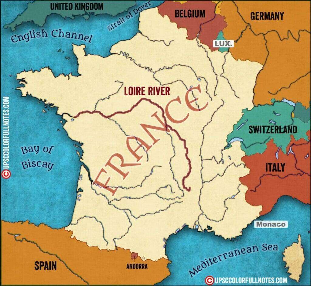
Loire river on Map
Loire River on Map: The Loire River, located in central France, is the longest river in the country. The river is known for its picturesque scenery and is a popular tourist destination. The Loire Valley, which the river runs through, is home to many historical castles and is a UNESCO World Heritage Site. The Loire River has been an important trade route since ancient times and is still an important part of French culture today. The Loire Valley is a UNESCO World Heritage site
The Loire River is about 1,006 kilometres long and is the longest river in France. It rises from the Massif Central foothills in the Cévennes mountain range, which is situated in the French département of Ardéche. The river then traverses the northern and western regions of France before emptying into the Bay of Biscay. Erdre, Nièvre, Maine, Cher, Vienne, Sèvre Nantaise, Allier, and Indre are some of the main tributaries of the Loire river. The Forest of Orléans is the biggest forest in France and is situated in the centre portion of the Loire river basin. It comprises an area of around 94,480 acres.
Loire River Basin
The Loire River is the longest river in France and one of the country’s most important waterways. The river basin covers more than a third of the country and is home to some of France’s most famous wine regions, as well as numerous historic towns and villages. The Loire Valley is a popular tourist destination for its stunning scenery, world-renowned wines, and cultural heritage.
The Loire River is the largest French basin with a total surface area of 117,800 km2 and 1013 km long from the spring to the estuary. In its upstream part, the basin is composed of the
- Upper Loire (480 km long, 17,570 km2 of surface area)
- Allier sub-basins (421 km. 14,310 km2).
The downstream part of the Loire basin drains three main tributaries on the left bank
- Cher (368 km, 13,920 km2),
- Vienne (372 km, 21,161 km2),
- Indre sub-basins (279 km, 3428 km2)
And Maine (23,314 km2) sub-basin on the right bank.
Loire River Basin- Wines
The Loire River Basin is home to some of the finest wines in the world. The climate and soil in this region are ideal for growing grapes, and the wine producers in this area have perfected the art of winemaking. The result is a wide variety of delicious wines that are perfect for any occasion.
There are many different types of Loire Basin wines, but some of the most popular include Chenin Blanc, Sauvignon Blanc, and Cabernet Franc. These three grape varieties produce white wines that are dry and refreshing, red wines that are full-bodied and complex, and pink wines that are light and fruity.
Loire River Path
The river begins at the foot of the Gerbier de Jonc in the Cévennes, near the Mediterranean coast, at approximately 1,370 metres above sea level. It runs through a series of downfaulted, flat-floored basins in the Massif Central highlands throughout its upper course. Its valley narrows to gorges as it crosses them. The substantially larger stream rushes over the limestone plateau of Berry after being joined by the Allier, and its valley becomes simply a narrow groove.

Loire Basin cultural heritage sites
The Loire Basin in France is home to numerous cultural heritage sites that are worth visiting. The region is known for its castles, which are some of the most well-preserved in all of Europe. In addition to the castles, there are also many cathedrals and other religious sites that date back centuries.
If you’re interested in French history, then a visit to the Loire Basin is a must. There are few other places in the world where you can see such a concentration of well-preserved historical sites. Whether you’re interested in architecture, art, or simply learning more about the country’s rich history, the Loire Basin has something for everyone.
Climate
The Loire Basin has a moderate Mediterranean climate with no persistent dry season and considerable precipitation, including winter snowfall, in its upper basin’s highlands. The region around its headwaters is also susceptible to powerful Mediterranean autumn storms. The river is often at its maximum level in late winter, but there is no hard-and-fast rule; floods may occur at any time of year, albeit not typically in July and August.
The Loire Basin is located in the central part of France and extends from the Massif Central to the Atlantic Ocean. The climate in this region is influenced by both maritime and continental air masses. The result is a climate that is mild with moderate rainfall.
The average temperature in the Loire Basin is 10 degrees Celsius. The warmest months are July and August, when temperatures can reach up to 25 degrees Celsius. The coldest months are January and February, when temperatures can drop to -5 degrees Celsius. (Loire river on Map)
Agriculture
The Loire River Basin has a long history of agriculture. Significant agricultural reclamation started in the 14th century and was aided by the involvement of the French court in the 15th and 16th centuries when the middle Loire valley supported a strip of land extensively farmed for cash crops. Its economy peaked in the 18th century, prior to the French Revolution.
The Loire River Basin is one of the most important agricultural regions in France. The basin covers an area of over 27,000 square kilometers and includes the departments of Loir-et-Cher, Indre, Maine-et-Loire, Sarthe, Mayenne, and Anjou. The region is known for its high quality wines and produce, as well as its dairy products. (Loire river on Map)
The Loire River Basin is home to a number of large farms and agro-industries. The region produces a significant amount of wheat, barley, oats, and rye. In addition to grains, the basin also grows a variety of fruits and vegetables. The Loire River Basin is one of the largest producers of wine in France. The region is also known for its cider production.
Waterways
The river served as a major corridor for commodities transit, and the communities along its banks served as important ports. During the 17th and 18th centuries, canal linkages were created, linking the Loire navigation with the Seine system of navigable rivers, allowing items to be transported to Paris. These linking waterways are too small for modern boats, limiting their utility. The Loire countryside has been left behind by new advances, remaining largely rural and unaffected by modern industries.
The Loire River Basin is located in central France and is home to a number of important waterways. The basin covers an area of over 117,800 km2 and 1013 km long from the spring to the estuary, and is home to a variety of different ecosystems. The Loire River itself is over 1,006 kilometers long and is the longest river in France. The basin is also home to a number of smaller rivers and streams, as well as a number of lakes and reservoirs. (Loire river on Map)
The Loire River Basin is an important area for both tourism and industry. The region is home to a number of different tourist attractions, including the city of Tours, the châteaux of the Loire Valley, and the vineyards of the Anjou region. The basin also contains a number of important industrial centers, including the city of Nantes.
In conclusion, the Loire River is an important part of France. It is a beautiful river that has many different features. It is a popular destination for tourists, and it is also a great place to live. The river has a long history and it is one of the most famous rivers in the world.
Download Loire river on Map HD
You can download the Loire river on Map HD from our telegram Channel : click the button to join