Latest Topics in News


Where is Tungabhadra river
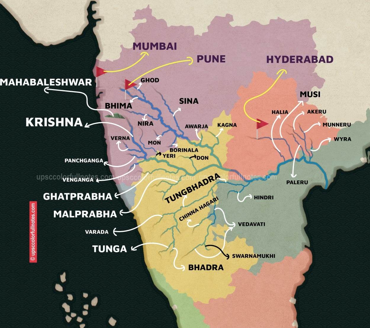
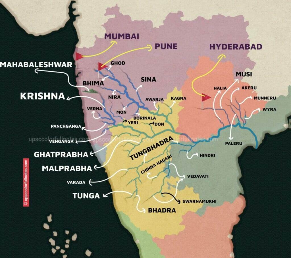
The Tungabhadra River originates from the confluence of two tributaries – the Tunga and Bhadra rivers – which arise in the Western Ghats mountain range. The Tunga begins in the Gangrikal hill ranges north of Kudremukh, the Bhadra emerges from the Aroli Hills. Both flow eastward separately before uniting at Kudli village in Shimoga district, Karnataka.
What is the Size of Tungabhadra river Basin
Spanning nearly 300 kilometers across Karnataka and Andhra Pradesh, the Tungabhadra being an important river in India is also a major tributary of the mighty Krishna River. Its expansive basin and irrigation command area covers 27 taluks over nearly 50,000 square kilometers across seven districts in the region.
How did the Tungabhadra River get its name?
The Tungabhadra River is named after the confluence point of two tributaries – the Tunga and Bhadra rivers – near Koodli village in Shimoga, Karnataka. The fusion of these two rivers forms the mighty Tungabhadra.
What is the Significance of Tungabhadra river
The Tungabhadra River holds mythological significance, arising from the holy confluence of the Tunga and Bhadra rivers associated with Lord Vishnu’s Varaha incarnation. As it flows through Hampi’s ancient granite boulders, the Tungabhadra turns strikingly picturesque. Its mineral-rich waters, originating from the Sahyadris, make it sweet and pure.
However, the Tungabhadra grapples with considerable pollution from agricultural and industrial activities, impacting local livelihoods. Another rising concern is the river’s crocodile population jeopardizing safety along its banks. Despite these challenges, the Tungabhadra maintains deep cultural and historical significance as both ancient myths and modern communities converge along its waters.
What are the Key Features of Tungabhadra river
The 5 Key Features of Tungabhadra river are:
- Tungabhadra is the largest tributary of the river Krishna.
- It is formed by the confluence of river Tunga and river Bhadra.
- The river Tunga and Bhadra originate at Gangamula in Chikmagalur district in Karnataka, near the origin of the Nethravati river, which flows into the Arabian sea.
- The famous Hampi site (UNESCO World Heritage site) lies on the river Tungabhadra.
- The famous Virupaksha temple also is on the banks of river Tungabhadra.
What are the tributaries of the river Tungabhadra
The Tungabhadra River has 6 tributaries. The six main tributaries of Tungabhadra River are the Tunga, Bhadra, Varada, Hagari, Haridra, and Kumudavathi Rivers. Tungabhadra merges into river Krishna in Andhra Pradesh.

What is the Tungabhadra Dam?
The Tungabhadra Dam, also known as Pampa Sagar, is a multifunctional dam on river Tungabhadra, located near Hosapete in Ballari district, Karnataka. It was constructed by Dr. Thirumalai Iyengar in 1953.
Where is Tungabhadra dam
Tungabhadra dam regulating the river Tungabhadra stands tall near Hospet, Karnataka, underscoring the river’s importance for the water-scarce state. Over 60% of drought-prone Karnataka state relies on rivers like the Tungabhadra to quench the thirst of people, farms and industries while tackling recurrent water stress.
What are the key features of the Tungabhadra Dam?
The Tungabhadra Dam stands 49.39 meters tall and has a length of 2,441 meters. It was built using cement and granite with two barrages, one earthen and one stone-surfaced, on its left side. The dam creates a 378 square kilometer reservoir with a substantial storage capacity of 4 lakh hectares.
What is the importance of the Tungabhadra Dam?
The Tungabhadra Dam serves as a vital lifeline for six drought-prone districts across Karnataka and Andhra Pradesh states. In addition to irrigating extensive agricultural areas, it also generates hydroelectricity and helps control flooding in the Krishna River basin. The dam sustains the farming region across Bellary, Koppal, and Raichur districts in Karnataka that is a major rice producer for the state.
What are the power houses associated with the Tungabhadra Dam?
The Tungabhadra Dam project has resulted in the construction of three power plants:
- The first power plant is located to the left in Munirabad, Karnataka with a capacity of 27 MW.
- The second power plant at Hospet has eight 9 MW generators adding up to a total capacity of 72 MW.
- Near Hampi, a third 27 MW capacity power plant has been built along the canal.
The total power generation from these three plants is 126 MW, which is utilized for irrigation and promoting small-scale industries in the region.
What are the key canal systems originating from the Tungabhadra Dam?
The Tungabhadra Dam is primarily an irrigation project supporting expanded agriculture in the region. The dam has given rise to three major canal systems:
- Tungabhadra Left Bank Canal (Tungabhadra Canal): 340 km long; Irrigates 3.32 lakh hectares across Raichur and Mahbubnagar districts
- Tungabhadra Low-Level Canal: 347 km long; Irrigates 60,000 hectares in Bellary and Kurnool districts
- Tungabhadra High-Level Canal: 196 km long; Irrigates 1.82 lakh hectares in Bellary and Anantapur districts
These extensive canal systems sustain the cultivation of cotton, rice, sugarcane and other crops in the region.
What is the catchment area of the Tungabhadra River basin?
The total catchment area of the Tungabhadra River basin, spanning its origin to its convergence with the Krishna River in Telangana, is 71,417 square kilometers. This accounts for 27.6% of the larger Krishna River basin area covering 259,077 sq km.
What is the catchment area of the Tungabhadra within Karnataka state?
The catchment area of the Tungabhadra River within Karnataka state, before it crosses into Telangana, spans 57,548 square kilometers. This excludes the portion of the Vedavati River flowing through Andhra Pradesh state, measuring 7,148 sq km.
So in short, the Tungabhadra basin includes the convergence of Tunga and Bhadra rivers in Karnataka, with a catchment of 57,548 sq km in the state, ultimately flowing into the Krishna River basin spanning over 250,000 sq km.
How is the Tungabhadra River basin divided into agro-climatic zones?
The Tungabhadra River sub-basin is categorized into three primary agro-climatic zones:
- Dry Zone: Covers 66% of land area
- Transition Zone: Accounts for 18% of area
- Hilly Zone: Comprises 14% area, dominated by the Western Ghats
What is the climate and topography of the Tungabhadra basin?
With an average elevation of 1,200 meters, the Western Ghats region of the Tungabhadra basin basin experiences:
- Average annual rainfall: 2,300 mm
- Average temperature: 24°C
The middle region of the basin between the Tunga-Bhadra confluence and Tungabhadra dam is hilly with:
- Average rainfall: 800 mm
- Average temperature: 26°C
The lower Tungabhadra basin below the dam has black cotton soil lands that are irrigated, with:
- Average rainfall: 600 mm
- Average temperature: 27°C
What administrative divisions fall under the Tungabhadra River basin?
The Tungabhadra sub-basin encompasses:
- 13 districts
- About 68 taluks
- 1,697 villages
- 2 municipal corporations
- 14 municipalities/councils
- 5 district headquarters
It includes Bellary, Chitradurga, and Davangere districts entirely, while Haveri, Davangere Koppal, Shivamogga, and Chikmaglur districts substantially fall under the basin.
What is the Biodiversity in the Tungabhadra River?
Some popular fish species inhabiting the Tungabhadra River include:
- Tilapia Galileae – Commonly caught for food by locals
- Catla Catla – Another staple food fish for regional communities
- Channa Striata – Known as striped catfish, popular among anglers
In addition to fish, the Tungabhadra river supports:
- Macroinvertebrates like insects, mollusks and crustaceans that are ecologically vital
- Riparian vegetation along the banks, harboring rich biodiversity
In 2015, a 34 km stretch of the river was designated the “Tungabhadra Otter Conservation Reserve” specifically to protect the endangered otter population.
There are 5 wildlife sanctuaries and a national park situated within the greater Tungabhadra basin that harbor valuable floral and faunal biodiversity.
What is the cultural significance of Tungabhadra River?
The Tungabhadra holds deep cultural significance, with various temples and pilgrimage sites situated along its banks that attract thousands of devotees.
One exceptionally notable site is the UNESCO World Heritage site of Hampi – an ancient village populated with historic ruins and monuments from the prosperous Vijayanagara Empire. The Vijayanagara canal network flowing through Hampi is considered an integral part of the recognized cultural landscape and is managed by the Hampi World Heritage Area Management Authority.
What are the major causes of pollution in the Tungabhadra River?
The four major causes of pollution in the Tungabhadra River are:
- Industrial Effluents: Industries and mines in the catchment area, especially in Shimoga, Bhadravati, Hospet (Karnataka) and Andhra Pradesh border towns, release untreated effluents into the river.
- Inadequate Sewage Treatment: Discharge of raw sewage into the river from towns like Harihar, Davangere City Corporation, Sringeri etc. due to lack of treatment plants.
- Agricultural Activities: Chemical fertilizers and pesticides from farmlands get washed into tributaries, accumulating toxins and salts in the river.
- Urbanization: Growing water demand from expanding cities and towns has compounded pollution levels.
How does the pollution impact Tungabhadra?
The contamination has severely degraded the quality of the Tungabhadra river, turning the downstream water dark brown with a foul odor. This pollution has directly affected over 1 million people in the sub-basin who traditionally relied on the Tungabhadra’s clean waters for drinking, irrigation, fishing, livestock rearing and more. Additionally, the toxins have caused recurring fish kills, devastating the river’s fisheries and fisherfolk’s livelihoods.
Effluents from factories and mines have made the Tungabhadra one of India’s most polluted rivers, severely impacting human populations and ecosystems across the sub-basin.