Latest Topics in News


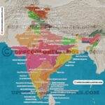
Neighbouring Countries Of India On Map
As we look at the map of India, it becomes clear that this vast nation is surrounded by a number of neighbouring countries. These neighbours are diverse in their geography, culture, Climate, Planting zones and languages, and have played an important role in shaping India’s history and identity.
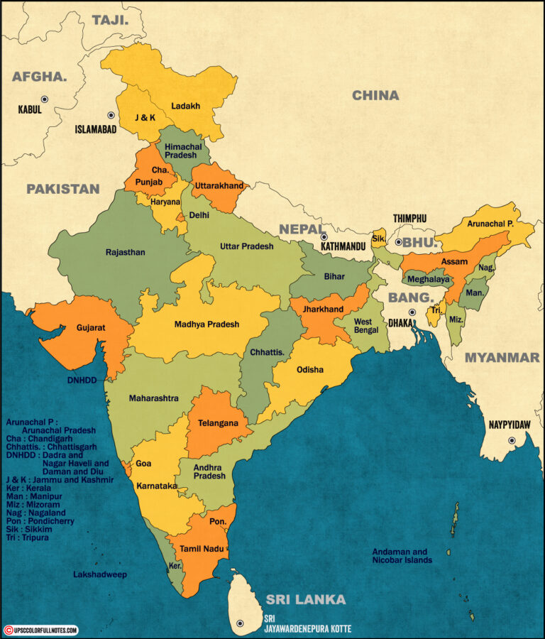
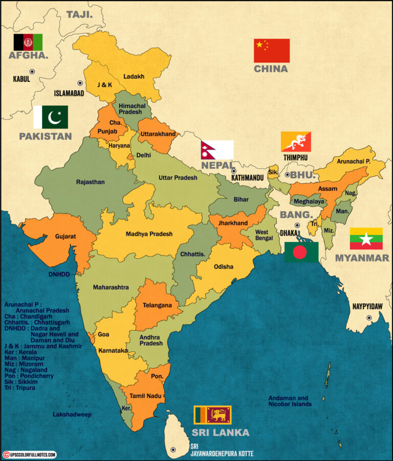
In this article, we will explore the neighbouring countries of India on map and learn about their unique characteristics. To begin with, let us take a glance at the seven countries that share borders with India: Afghanistan to the northwest; Pakistan to the west; China, Nepal and Bhutan to the north; Bangladesh to the east; and Myanmar to the east-southeast.
| Total Neighbouring Countries of India | 9 |
|---|---|
| Name of Neighbouring Countries Of India On Map | The countries are Afghanistan, Bhutan, Bangladesh, Nepal, Sri Lanka, the Maldives, Myanmar, Pakistan, China. |
| Total Land Border of India | 15,106.7 k.m. |
| Toatal Length of India’s Coastline | 7516.6 k.m. |


| Neighbouring Countries Of India On Map | Bordering States |
| Afghanistan | Ladakh |
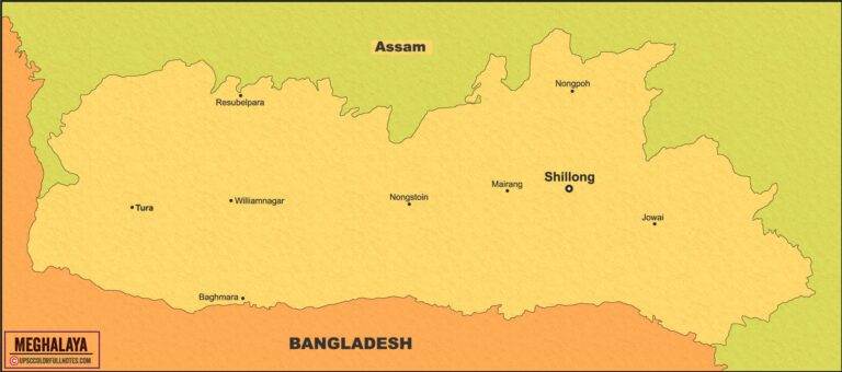
| Bangladesh | West Bengal, Meghalaya, Mizoram, Tripura and Assam |
| Bhutan | West Bengal, Sikkim, Arunachal Pradesh & Assam |
| China | Ladakh, Himachal Pradesh, Uttarakhand, Sikkim and Arunachal Pradesh |
| Myanmar | Arunachal Pradesh, Nagaland, Mizoram and Manipur |
| Maldives | south-west of India below the Lakshadweep Island |
| Nepal | Bihar, Uttarakhand, UP, Sikkim and West Bengal |
| Pakistan | J&K, Ladakh, Punjab, Rajasthan and Gujarat |
| Sri Lanka | Gulf of Mannar seprates India from Sri Lanka |
Afghanistan
Afghanistan’s unique culture and history make it an intriguing neighbor of India among the neighbouring countries on the map. Situated to the northwest of India, Afghanistan shares a border with India.
The two countries have shared trade, cultural, and historical ties for centuries. India has provided significant developmental aid to Afghanistan, including building infrastructure and supporting education initiatives. Both countries share a common interest in regional stability and economic growth.
Despite political turmoil in the region, India and Afghanistan have enjoyed close diplomatic relations for many years. Furthermore, Afghanistan is home to several ethnic groups with different languages, religions, and cultures. Such diversity adds richness to this nation’s history, making it an essential neighbour among the neighbouring countries of India on the map.
Pashtuns are one of the largest ethnic groups in Afghanistan who speak Pashto as their native language while Tajiks are another prominent group who speak Dari.
Moving on from Afghanistan as a fascinating country neighboring India on its western side lies Bangladesh- another vital neighbor that shares close cultural bonds with our country, refer Neighbouring Countries Of India On Map
Bangladesh
You’re probably familiar with Bangladesh, the country that borders India to the east. When looking at a map of neighbouring countries of India, it’s easy to spot Bangladesh as one of its closest neighbours. The Indian map with neighbouring country labels also clearly shows Bangladesh as bordering India on three sides – east, north-east and west.
The relationship between India and Bangladesh is complex and multifaceted. Both countries share a history, culture, and language, which has led to close ties between them. However, there have been conflicts over land disputes and illegal migration in recent years.
Despite these issues, the two nations continue to maintain friendly relations and work collaboratively on various economic and political fronts.
When we look at the map neighbouring countries of India, we can see how closely interlinked these nations are with each other. With Bangladesh being one of its immediate neighbours who share both a land boundary as well as cultural links with India.
As we move forward onto discussing Bhutan next, let’s take note that this kingdom is another one of India’s neighbours that shares a unique bond with it in many ways!
Bhutan
If you’re interested in exploring the quaint and charming kingdom of Bhutan, then be prepared to bask in its beauty and blissful atmosphere. Located on the eastern edge of the Himalayas, this small country is nestled between India and China.
In fact, Bhutan is one of the neighbouring countries of India on map, making it an ideal destination for those who want to experience a unique blend of culture and nature. When you look at an India map with border countries or an India political map with neighbouring countries, you’ll notice that Bhutan shares its northern border with Tibet (which is now part of China). This proximity has not only influenced Bhutanese culture but also their foreign policy.
Despite being a small country with limited resources, Bhutan has maintained a strong sense of independence by balancing their relationships with both India and China. Bhutan’s strategic location makes it more than just a tourist destination. As one of the border countries of India map, it serves as a buffer zone between two major powers in Asia.
While India remains one of Bhutan’s closest allies and trading partners, China has been making inroads into the region through infrastructure projects such as highways and railways. Understanding Bhutan’s complex relationship with its neighbours is crucial for anyone looking to explore this fascinating country further.
As we move on to the next subtopic about China, it’s important to recognize how neighbouring countries like Bhutan play a significant role in shaping regional dynamics. While our focus may shift towards larger powers like China or even Pakistan, we shouldn’t overlook smaller nations like Bhutan that have their own unique stories to tell within the greater narrative of South Asia. (refer Neighbouring Countries Of India On Map)
China
As one of India’s neighboring countries on the map, China shares a long border with India. The two countries have had a complex relationship over the years, ranging from diplomatic disputes to economic cooperation.
India map and neighboring countries are closely connected through trade and cultural exchange. As the world’s 2nd most populous country, China has much to offer in terms of its diverse landscapes, ancient landmarks, and modern cities. From the Great Wall to the Terracotta Army, there is no shortage of fascinating destinations.
When looking at India neighboring countries political map or India map with neighboring countries, it is clear that China plays an important role in shaping regional politics and economics. Despite occasional tensions between India and China over issues such as territorial disputes or strategic alliances with other nations, both sides have acknowledged the importance of maintaining stable relations for mutual benefit.
As we move on to our next subtopic about Myanmar, it’s worth considering how China’s influence extends beyond its immediate neighbors on the map. With its growing economy and geopolitical clout, China continues to be a major player in shaping global affairs today.
Myanmar
Myanmar, known for its breathtaking landscapes and rich cultural heritage. As one of India’s neighboring countries on the map, Myanmar shares a border with four Indian states: Mizoram, Manipur, Nagaland, and Arunachal Pradesh.
This long-standing relationship between the two countries has been strengthened further by recent efforts to enhance connectivity and trade between India’s North-Eastern region and Myanmar. India can be found on a world map with nearby countries such as Nepal, Bhutan, Bangladesh, Pakistan, China, and Sri Lanka. However, when examining an India map with surrounding countries marked out or neighboring countries of India on political maps, it is clear that Myanmar also forms an important part of India’s regional landscape.
The two nations have worked towards promoting cross-border trade in agricultural products like pulses and beans in recent years as well. The diverse topography of Myanmar ranges from snow-capped mountains to pristine beaches. The country is home to over 130 ethnic groups, each with their own unique customs and traditions which have contributed to its vibrant culture.
Nepal
Nepal’s majestic Himalayan peaks tower over its vibrant cities and diverse landscapes, making it a destination that offers both adventure and cultural experiences. As one of the neighbouring countries of India on the map, Nepal shares an open border with India and is easily accessible by land.
Its capital city, Kathmandu, is a popular destination for trekkers and tourists alike who are drawn to its ancient temples and palaces. India map with states and neighbouring countries reveals that Nepal is situated in the northern part of India. It shares borders with five Indian states: Uttarakhand, Uttar Pradesh, Bihar, West Bengal, and Sikkim.
The political map of India with neighbouring countries shows that Nepal has strong historical ties with India dating back to ancient times when they shared cultural practices. The geographical proximity between these two neighbours is reflected in their close economic ties as well.
Trade between India and Nepal is largely informal but significant in volume. Both nations have recently taken steps to improve connectivity by opening new air routes and building infrastructure such as roads and bridges. These initiatives aim to promote people-to-people contact as well as boost trade relations between the neighbouring countries of India on the world map.
As we move towards discussing Pakistan next, it’s noteworthy how both Pakistan and Nepal share important links with India despite having different geopolitical situations.
Pakistan
You can’t imagine the sheer size and diversity of Pakistan. It’s home to some of the world’s highest mountain ranges, bustling cities, and vast deserts. Pakistan shares a border with India that spans over 3323 kilometres. It’s located in South Asia and is neighboured by Afghanistan to the northwest, Iran to the southwest, China to the northeast, and India to the east.
Pakistan has a rich cultural heritage and history that dates back thousands of years. The country was formed in 1947 when it gained independence from British rule as part of a partition with India. Despite facing numerous political challenges and conflicts with its neighbours, Pakistan remains an important player in regional politics due to its strategic location between South Asia and Central Asia.
There’s an abundance of connections between these nations, ranging from the ancient trade routes that connected South Asia with Central Asia via what’s now Pakistan, to shared linguistic roots across many languages that are spoken in this region today, including Hindi-Urdu, which is spoken in both India and Pakistan.
Moving on from discussing Pakistan as one of our neighbouring countries on the map of India, political borders come into play once again when we consider Sri Lanka, which lies off the southern coast of Tamil Nadu. ( see the Neighbouring Countries Of India On Map to locate the nation)
Sri Lanka
If you’re interested in learning about a fascinating island nation, Sri Lanka is definitely worth considering. Situated off the southern coast of India, this small country occupies a strategic location in the Indian Ocean and shares maritime borders with India and the Maldives. To its east lies the Bay of Bengal, while to its west is the Arabian Sea. Sri Lanka’s geographic position has played a significant role in shaping its history, culture, and economy.
On an outline map of India with neighboring countries, Sri Lanka stands out as a distinct pear-shaped island that measures approximately 65,610 square kilometers. Despite being one of the smaller nations in South Asia, it boasts diverse landscapes ranging from pristine beaches to lush rainforests and misty mountains. The country’s rich biodiversity includes endemic species such as leopards, elephants, and monkeys that roam free in several national parks.
India and its neighbors’ map shows how close Sri Lanka is to India’s southern tip; only about 30 kilometers separate them at their closest point. Historically, these two countries have maintained close ties owing to trade relations and shared cultural influences such as Buddhism. Today, they collaborate on various fronts, including security cooperation and tourism promotion.
As we move on to discuss Maldives – another island nation located southwest of India – we will see how Sri Lanka fits into this larger regional context.
As we look towards our next topic on Maldives – another beautiful island nation located southwest of India – it’s interesting to note that both Sri Lanka and Maldives share similar characteristics when it comes to geography and culture. However, each country also has unique features that make it special in its way. Let’s delve deeper into what makes Maldives stand out among neighboring countries of India on the map!
Maldives
Moving on to our next topic, let’s explore the unique characteristics of the beautiful island nation of Maldives.
Located in the Indian Ocean, southwest of India and Sri Lanka, Maldives is made up of 26 atolls consisting of around 1,200 islands. The country covers an area of just over 300 square kilometers and has a population of approximately 530,000 people.
Maldives is known for its stunning natural beauty with crystal clear waters and white sandy beaches that attract millions of tourists every year. The country also has a rich culture and history with influences from India, Sri Lanka, and Arabia. Islam is the official religion and plays an important role in the daily lives of Maldivians.
Despite being one of the smallest countries in Asia, Maldives has a strong economy based on tourism and fishing industries. It has become a popular destination for honeymooners as well as those seeking adventure activities such as snorkeling, scuba diving, and surfing.
With its unique location among neighboring countries like India and Sri Lanka on the map, Maldives offers visitors a glimpse into a different world filled with natural wonders and cultural richness.
In conclusion, studying the neighbouring countries of India on map is essential for understanding India’s geopolitical position and its relationships with its neighbouring nations. It helps in understanding the cultural, economic, political, and historical ties that India has with its neighbouring countries. Furthermore, it is crucial to know the location of neighbouring countries for trade and commerce, national security, and international relations. India’s foreign policy is heavily influenced by its relationship with its neighbouring countries. Therefore, it is essential to study the neighbouring countries of India on map to gain a better understanding of India’s position in the world.


Thankyou So much