Latest Topics in News

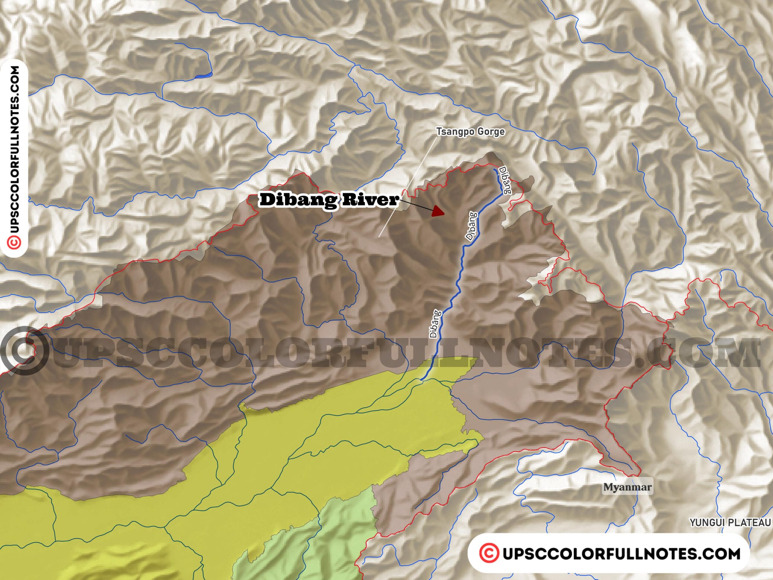


Dibang River
The Dibang River is one of the main rivers in the state of Arunachal Pradesh in northeast India. This river starts its journey near Keya Pass close to the border between India and China in the Upper Dibang Valley district. It flows down from the misty mountains of the Mishmi Hills range.
The Dibang River then passes through thick forests in the Lower Dibang Valley and Dibang Valley districts of Arunachal Pradesh. After traveling through very tough hilly terrain, the waters of the Dibang meet the Lohit River. Below where these two rivers join together, the combined river becomes known as the mighty Brahmaputra River.
By adding its glacier-fed waters to the Lohit, the Dibang River helps support the lives of millions of people living along the Brahmaputra River plains downstream in Assam and Bangladesh. The Dibang is truly a lifeline nurturing this remote corner of northeast India.
In this article, the UCN Team conducts a thorough analysis, providing key insights on the Dibang River alongwith Dibang river maps.
Geography and Hydrology
The Dibang River is fed by many tributaries including the Emra, Dri, Ithun, Mathun, Tangon, Aahar and Mipi rivers. The total length of the Dibang River is about 195 kilometers or 121 miles.
One notable feature of this river is its very steep gradient and braided shape, with multiple interlinking channels. Between the towns of Bomjir and Sadiya, the width of the river varies from around 4 kilometers (2 miles) to 9 kilometers (6 miles).
The Dibang River is the lifeline for the local communities living in its basin area. It provides water for irrigation, domestic use, navigation, hydropower generation etc. The river and its tributaries are home to many rare and endemic fish species. The basin area also has rich biodiversity of flora and fauna.
Origin and Course
The Dibang River originates near the Keya Pass on the Indo-Chinese border in the Mishmi Hills of Arunachal Pradesh’s Upper Dibang Valley district. It flows southwest through the rugged mountains and lush forests of the Dibang Valley district before entering the Assam plains near Sadiya.
The river flows in a southwest direction through lush green forests and rugged mountainous terrain. Major tributaries that join the Dibang River along its course include the Emra, Aahar, Mipi, Dri and Tangon rivers.
The Dibang River is fed by several key tributaries including the Mathun, Tangon, Dri, Ithun and Emra. Additionally, many smaller streams join the Dibang along its course. These include the Airi Pani, Ilu Pani, Imu Pani, Ahi, Ashupani, Epipani and Deopani rivers. Together, these tributaries originating from the snow-clad Eastern Himalayas contribute their glacier meltwater to swell the Dibang as it flows toward the Brahmaputra.

After flowing for nearly 195 km through the Lower Dibang Valley and Dibang Valley districts, the Dibang River is joined by the Lohit River near Kobo village. Below the confluence point, the combined river is called the Brahmaputra River.
The Dibang River traverses remote hilly areas with challenging terrain before merging into one of the largest rivers of Asia, the Brahmaputra. It is a major lifeline sustaining local communities along its banks.

Discharge and Flooding
The Dibang is a highly braided river with multiple interlaced channels and sandy islands. It carries massive amounts of sediment load from the Eastern Himalayas, leading to a wide unstable river bed.
During the monsoon months, the Dibang River swells up greatly in size and is prone to severe flooding. Sudden water level rise causes enormous damage through river bank erosion, changes in river course and destruction of infrastructure in its path.
The wiping out of Anpum and Loklung villages in 2015 is considered the worst disaster in the last 50 kilometers of the Dibang River’s course since 1950.
Over the past millions of years, the Dibang has formed a complex interlinked system with the local ecology, hydrology and geology. Its frequent change of course is influenced by various natural factors.
However, recent human activities have exacerbated the river’s erosive power. Logging in the Dibang Valley region and above-normal rainfall during monsoons in recent decades have made the Dibang more prone to sudden flooding and altering its channels. This led to the disastrous loss of Anpum and Loklung settlements.
Agricultural lands, villages, bridges and roads along the river banks suffer immense losses due to the raging flood waters. The Dibang has caused catastrophic floods in the Lower Dibang Valley district in recent years.
Dibang River Bridge
The Dibang River Bridge is an engineering marvel located in the Lower Dibang Valley district of Arunachal Pradesh. This 6.2 km long beam bridge spans across the mighty Dibang River, connecting Bomjir and Malek villages. It provides all-weather road connectivity on the NH13 highway between Dambuk and Roing towns in the eastern part of the state.
With its impressive length, the Dibang River Bridge is the second longest bridge over water in India. It was built as part of the ambitious Trans-Arunachal Highway project and opened for traffic in 2018 after successful completion. The bridge construction faced initial resistance from local communities but was eventually finished and tested successfully.
The Dibang River Bridge stands tall as the longest bridge in Arunachal Pradesh, overcoming geographical barriers and bringing progress to remote border areas. It has reduced travel time between key towns significantly, boosting socio-economic growth in the region. The bridge is an engineering achievement that has improved connectivity in eastern Arunachal Pradesh.
Biodiversity and Ecology
The Dibang River basin is home to a rich variety of endemic and endangered animal and plant species. The river habitats support many rare fish like the golden mahseer, additionally, the Dibang River is part of the Dihang-Dibang Biosphere Reserve, which is rich in wildlife, including rare mammals and birds
Dense tropical forests in the region harbor populations of hoolock gibbon, clouded leopard, tiger and hundreds of bird species. The biodiversity of the Dibang valley is under grave threat from upcoming hydropower projects and related construction activities.
Deforestation driven by logging and land use changes, as well as the effects of climate change on Himalayan glaciers are also impacting the sensitive ecology of the region. Proper environmental impact assessment and mitigation measures are crucial before planning large projects in the region.

Human Use and Threats
The Dibang River is the lifeline sustaining local communities, including the Idu Mishmi community, living along its banks and tributaries. It provides water for drinking, irrigation, fishing, transportation and other daily needs.
However, the rich hydropower potential of the river basin has attracted proposals for many massive dam and hydroelectric projects. While this development could bring economic benefits, it also poses grave risks of ecological damage and loss of biodiversity in the region.
Activities like deforestation, mining, road construction etc. associated with these projects can lead to irreversible impacts on the fragile Himalayan ecosystem. There is an urgent need for sustainable development of the river basin with minimal ecological impact.
Final Thoughts
As far as the UCN team can tell, the Dibang River basin represents an ecologically vital but fragile Himalayan river system. The development goals for the region must strive to achieve a careful balance between economic growth, and environmental sustainability and conservation.
For judicious management of water, energy and ecological resources, a multi-stakeholder basin-level planning process is essential. This should involve local communities, subject experts, governments and other stakeholders. Sustainable development of the Dibang River basin is crucial for the future of the region.