Latest Topics in News

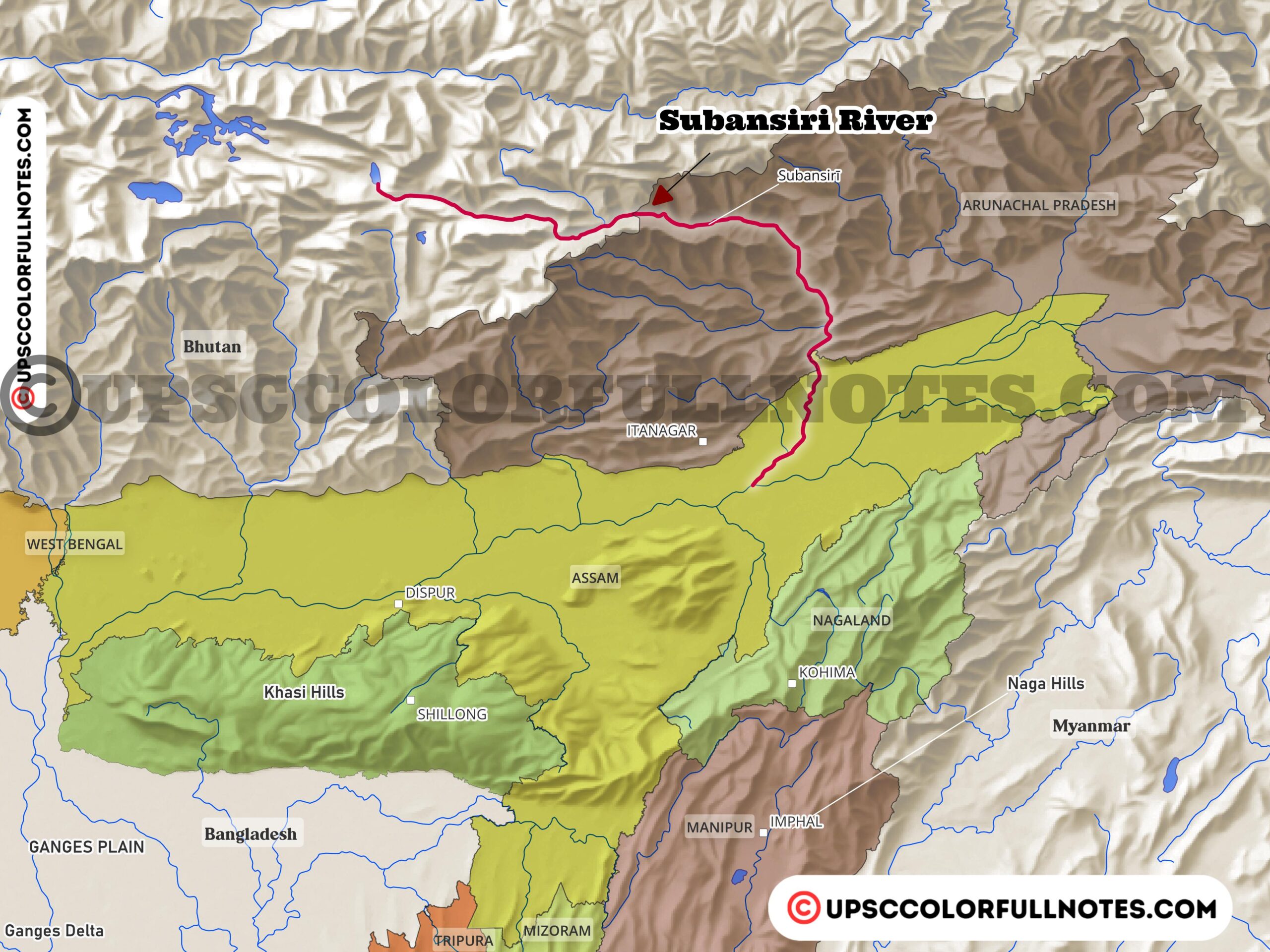


Subansiri River
The Subansiri River is one of the largest tributaries of the mighty Brahmaputra River in northeast India. With a length of 442 km, the Subansiri River originates from the Himalayas and then flows through the states of Arunachal Pradesh and Assam before joining the Brahmaputra River.
In this article, the UCN Team provides a detailed analysis, presenting key insights on the Subansiri River and its major tributaries alongwith Subansiri River Map.
The Subansiri is an important lifeline and provides water resources for the people living in the districts of Lakhimpur and Dhemaji in the state of Assam. It is described as the “Gold River” and the lifeline of the people of these two districts.
The river contributes significantly to the flow of the Brahmaputra – around 7.92%. This makes it one of the most important tributaries of the Brahmaputra.
The Subansiri flows through some scenic gorges and difficult hilly terrain as it exits the Himalayas before entering the Assam plains.
| Subansiri River | Details |
|---|---|
| Subansiri River | – Largest tributary of the Brahmaputra River |
| – Flows through Arunachal Pradesh and Assam | |
| – Ecological, economic, and hydropower importance | |
| Geography and Hydrology | – Origin in Tibet, merges with Brahmaputra in Assam |
| – 442 km length, 32,640 sq km drainage basin | |
| – Major tributaries – Kamla and Kurung Rivers | |
| Ecology and Economy | – Diverse aquatic habitats support fish species |
| – Provides livelihoods through fishing | |
| – Potential for inland water transport | |
| Hydropower Potential | – Site of Lower Subansiri Hydroelectric Project (2000 MW) |
| – One of the biggest hydro projects under construction in India |
Geography and Hydrology
The Subansiri River originates high up in the Himalayan mountains near the Tibetan plateau. Its headwaters lie beyond the high peaks of the Central Himalayan range, at an average elevation of around 17,000 feet (5,182 meters).
In the upper reaches, the Subansiri flows generally west to east, fed by numerous small snow-fed tributaries draining the Himalayan slopes. Here it is known by the Tibetan name Tsari Chu.
Further downstream, the Subansiri cuts through rugged terrain, traversing a series of high Himalayan ridges reaching up to 18,000 feet (5,486 meters). It follows a winding southeastern course through the Lesser Himalayan zone with an average height of 10,000 feet.
After passing through the outermost Himalayan foothills called the Siwalik Range, the Subansiri River finally emerges from the mountains near Dulungmukh into the Assam plains. It carves a steep and scenic gorge through the Siwalik hills before entering the plains.
The total drainage area of the Subansiri in the Himalayas spans around 30,000 sq km from elevations of 18,000 feet down to 500 feet near Dulungmukh. The overall length of the river through the mountains is approximately 208 km. There is a steep drop in elevation from 13,800 feet in the high Himalayas down to just 500 feet at the outer foothills.
On its long journey from the Tibetan plateau to the Assam plains, the Subansiri gathers water from numerous tributaries, especially in the Siwalik foothills zone.
The Subansiri has two major sub-basins – the Ranganadi and Dikrong Rivers – which also originate in the Himalayas. These tributaries drain separate watersheds, flow through the mountains and hills, cross the Assam plains, and finally join the main Subansiri River before it meets the mighty Brahmaputra.

Subansiri River Tributaries
The Subansiri River basin includes countless smaller streams flowing down from the Arunachal Himalayas which join the main valley.
After emerging from the mountains near Dulangmukh, the Subansiri flows about 72 km southwards through the plains before changing course southwest to meet the Brahmaputra.
Ranganadi
The Ranganadi River is a major tributary of the Subansiri River in northeastern India. It originates high up in the Dafla hills of Arunachal Pradesh at an altitude of 3,400 meters.
Flowing down from these Himalayan hills, the Ranganadi traverses through the Lesser Himalaya mountain range, then the Outer Himalaya foothills, before emerging out into the Brahmaputra River valley plains.
The Ranganadi’s water flow varies between 130 to 900 cubic meters per second, with high discharge during the monsoon season. Along its course, it is fed by meandering tributaries like the Singra, Pabha, Boka and Gerala Rivers.
Entering the state of Assam near the town of Johing, the Ranganadi River winds its way for around 60 km through the plains before meeting the Subansiri River at Pokoniaghat in Lakhimpur district.
Dikrong River
The Dikrong River starts in the Himalayan mountains of Arunachal Pradesh in northeast India. It flows for 145 km before joining the mighty Brahmaputra River.
For most of its course, the Dikrong winds through hilly terrain in Arunachal Pradesh. Then it enters the Assam plains for the last 32 km.
Many small streams and tributaries join the Dikrong along its path. Some main tributaries are the Keyate, Pang Nala, Shu Pabung, Peti Nala, Ranchi Pabung, Pachin Nadi, and Beguli Nadi.
Originally, the Dikrong met the Brahmaputra through its Kharkatiasuti channel. But this channel was blocked. Now the Dikrong joins a spill channel of the Subansiri River first. The Subansiri then meets the Brahmaputra.
During big floods, some water from the Dikrong still reaches the Brahmaputra directly.
Kamla River
The Kamla River’s upper catchment area is covered with snow clad mountains, glaciers, barren and rocky wasteland, while most of the catchment is covered with semi-dense mixed subtropical and semi evergreen forests. It meets the Subansiri near Rachrath village.
Kurung River
Similar to the Kamla, the upper catchment of the Kurung River is also covered in snow clad mountains, glaciers and barren rocky wasteland. However, most of its catchment area is covered in semi-dense mixed subtropical and semi evergreen forests. The Kurung meets the Subansiri near Rai and Bao villages.
The approximate lengths of these major tributaries across the plains are: Subansiri 173 km, Ranga 80 km and Dikrong 48 km. They have typically meandering courses across the flat alluvial plains.
Morphology and Geology
The Subansiri River flows through gravel, silt and sand riverbed in the Assam Valley. It is prone to heavy erosion and channel shifting as it exits the Himalayas, resulting in an unstable river course near the Assam plains.
The river flows through scenic yet difficult gorges along this transitional stretch. Significantly, the Subansiri channel has shifted westward over 6 km near Chouldhowaghat since 1950 due to the erosion, indicating the river’s high instability near the plains. In short, the dynamic Subansiri River transitions from a stable channel in the mountains to an unstable, braided channel as it enters the Assam floodplains.

Climate
The Subansiri valley has a cool, humid climate with heavy monsoon rains from June to September which bring about 80% of the annual precipitation. Winter months are drier and cooler, with average minimum temperatures around 10°C in January.
Occasional localized hailstorms occur during monsoons, sometimes damaging crops and tea gardens. However, there is little rainfall in the winter dry months of November and December. Overall, the Subansiri River valley climate is characterized by wet summers with heavy monsoon rains and cooler, drier winters.
Biodiversity and Resources
The Subansiri River basin provides diverse aquatic habitats like streams, wetlands and riparian zones. It is an important source for fishing activities for local communities. The vegetation includes pine, oak and rhododendron forests in the Himalayan reaches, and tropical wet evergreen forests and grasslands in the Assam plains.
The Subansiri supports rich biodiversity of fish, reptiles, birds and mammals, including endangered species like river dolphins, pygmy hogs and white-winged wood ducks. The wetlands along the river are important habitats and food sources for birds, as well as for local people.
Issues and Projects
Navigation and inland water transport projects are being undertaken along the Subansiri River. Flood control and bank protection efforts are also underway to manage the devastating floods the Subansiri is prone to.
The development of hydropower plants on the Subansiri is being explored given its large hydroelectric potential. The Lower Subansiri Hydro Electric Project is one such project under development.
Some other key issues and projects on the Subansiri River include:
- Efforts to monitor and manage erosion and channel shifting of the river.
- Maintenance and dredging to improve navigability along the river .
- Conservation of aquatic biodiversity and management of riparian habitats.
- Studies to better understand hydrological flows and sediment loads.
Final Thoughts
According to the UCN team’s analysis, the Subansiri River is a vital river for the northeastern state of Assam.
It provides important water resources for the people of Assam while also being rich in aquatic life. However, the Subansiri is prone to frequent and devastating floods, as mentioned across the documents reviewed.
Efforts are underway to manage and control the floods, as well as utilize the Subansiri River for inland navigation and transport.
Other key efforts include bank protection works, monitoring of erosion, conservation of biodiversity, tourism promotion, and hydropower development on the Subansiri River.
In summary, the mighty Subansiri is a significant river system in Assam, requiring balanced management for flood control and utilization of its resources for development. Ongoing projects aim to achieve this through sound engineering and scientific management of the river basin.